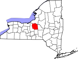
Onondaga County
 Onondaga County Courthouse |
|
| administration | |
|---|---|
| US state : | new York |
| Administrative headquarters : | Syracuse |
| Foundation : | 1792 |
| Made up from: | Herkimer County |
| Area code : | 001 315 |
| Demographics | |
| Residents : | 467,026 (2010) |
| Population density : | 231.1 inhabitants / km 2 |
| geography | |
| Total area : | 2087 km² |
| Water surface : | 66 km² |
| map | |
| Website : www.ongov.net | |
The Onondaga County is a county in the state of New York of the United States . At the 2010 census , the county had 467,026 people and a population density of 231 people per square kilometer. The county seat is Syracuse .
history
The county was formed in 1792 and named after the Onondaga Indians .

One place has the status of a National Historic Landmark , the New York State Barge Canal . A total of 145 buildings and sites in the county are registered on the National Register of Historic Places (as of February 19, 2018).
geography
The county has an area of 2087 square kilometers, of which 66 square kilometers are water. It borders on Oneida Lake and shares part of Skaneateles Lake . Onondaga Lake and Otisco Lake are completely in Onondaga County .
Cities and towns
Web links
Individual evidence
- ↑ GNIS-ID: 974132. Retrieved on February 22, 2011 (English).
- ↑ Listing of National Historic Landmarks by State: New York . National Park Service , accessed February 19, 2018.
- ↑ Search mask database in the National Register Information System. National Park Service , accessed February 19, 2018.
Coordinates: 43 ° 1 ′ N , 76 ° 12 ′ W

