Pangboche: Difference between revisions
No edit summary |
No edit summary |
||
| (17 intermediate revisions by 15 users not shown) | |||
| Line 3: | Line 3: | ||
<!--See the table at Infobox settlement for all fields and descriptions of usage--> |
<!--See the table at Infobox settlement for all fields and descriptions of usage--> |
||
<!-- Basic info --> |
<!-- Basic info --> |
||
|name = Pangboche |
| name = Pangboche |
||
|other_name = |
| other_name = |
||
|native_name |
| native_name = पाङ्बोचे |
||
|nickname = |
| nickname = |
||
|settlement_type = Village |
| settlement_type = Village |
||
|motto = |
| motto = |
||
<!-- images and maps --> |
|<!-- images and maps --> |
||
|image_skyline =Pangboche.JPG |
| image_skyline = Pangboche.JPG |
||
|image_caption = Pangboche with [[Ama Dablam]] behind |
| image_caption = Pangboche with [[Ama Dablam|Ama Dablam mountain]] behind |
||
|image_flag = |
| image_flag = |
||
|image_seal = |
| image_seal = |
||
|image_map = |
| image_map = |
||
|mapsize = |
| mapsize = |
||
|map_caption = |
| map_caption = |
||
|pushpin_map = Nepal |
| pushpin_map = Nepal |
||
|pushpin_label_position = bottom |
| pushpin_label_position = bottom |
||
|pushpin_mapsize = 300 |
| pushpin_mapsize = 300 |
||
|pushpin_map_caption = Location in Nepal |
| pushpin_map_caption = Location in [[Nepal]] |
||
| ⚫ | |||
<!-- Location --> |
|||
| subdivision_name = {{flag|Nepal}} |
|||
| ⚫ | |||
| |
| subdivision_type1 = [[Provinces of Nepal|Province]] |
||
| |
| subdivision_name1 = [[Province No. 1]] |
||
| |
| subdivision_type2 = [[Zones of Nepal|Zone]] |
||
| |
| subdivision_name2 = [[Sagarmatha Zone]] |
||
| |
| subdivision_type3 = [[Districts of Nepal|District]] |
||
| ⚫ | |||
|subdivision_type3 = VDC |
|||
| subdivision_type4 = [[Local government area|Area]] |
|||
| ⚫ | |||
| subdivision_name4 = [[Khumjung]] |
|||
|<!-- Politics --> |
|<!-- Politics --> |
||
|government_footnotes = |
| government_footnotes = |
||
|government_type = |
| government_type = |
||
|leader_title = |
| leader_title = |
||
|leader_name = |
| leader_name = |
||
|leader_title1 = <!-- for places with, say, both a mayor and a city manager --> |
| leader_title1 = <!-- for places with, say, both a mayor and a city manager --> |
||
|leader_name1 = |
| leader_name1 = |
||
|established_title = <!-- Settled --> |
| established_title = <!-- Settled --> |
||
|established_date = |
| established_date = <!-- Area --> |
||
| unit_pref = <!--Enter: Imperial, if Imperial (metric) is desired--> |
|||
<!-- Area --> |
|||
| |
| area_footnotes = |
||
| ⚫ | |||
|area_footnotes = |
|||
| ⚫ | |||
<!-- Population --> |
<!-- Population --> |
||
|population_as_of = 1991 |
| population_as_of = 1991 |
||
|population_footnotes = |
| population_footnotes = |
||
|population_note = |
| population_note = |
||
|population_total = |
| population_total = |
||
|population_density_km2 = auto |
| population_density_km2 = auto |
||
|population_blank1_title = Ethnicities |
| population_blank1_title = Ethnicities |
||
<!-- General information --> |
<!-- General information --> |
||
|timezone = [[Nepal Time]] |
| timezone = [[Nepal Standard Time|NST]] |
||
|utc_offset = +5:45 |
| utc_offset = +5:45 |
||
|timezone_DST = |
| timezone_DST = |
||
|utc_offset_DST = |
| utc_offset_DST = |
||
| coordinates = {{coord|27|51|N|86|48|E|type:adm2nd_region:NP_source:unmaps-enwiki|display=inline,title}} |
|||
|latd=27|latm=51|lats=|latNS=N |
|||
| ⚫ | |||
|longd=86 |longm=48|longs=|longEW=E |
|||
| ⚫ | |||
|coordinates_display = title |
|||
|coordinates_type = type:adm2nd_region:NP_source:unmaps-enwiki |
|||
| ⚫ | |||
| ⚫ | |||
<!-- Area/postal codes & others --> |
<!-- Area/postal codes & others --> |
||
|postal_code_type |
| postal_code_type = <!-- enter ZIP code, Postcode, Post code, Postal code... --> |
||
|postal_code = |
| postal_code = |
||
|area_code = |
| area_code = |
||
|blank_name = |
| blank_name = |
||
|blank_info = |
| blank_info = |
||
|website = |
| website = |
||
|footnotes = |
| footnotes = |
||
}} |
}} |
||
'''Pangboche''' or '''Panboche''' is a village in [[Khumjung]] |
'''Pangboche''' or '''Panboche''' is a village in [[Khumjung]] [[Village development committee (Nepal)|Village Development Committee]] of [[Solukhumbu District]] in [[Province No. 1]] of [[Nepal]] at an altitude of {{convert|13074|ft}}.<ref name="Deutschle2012">{{cite book|last=Deutschle|first=Phil|title=The Two-Year Mountain: A Nepal Journey|url=https://books.google.com/books?id=a80oM5xNIaAC&pg=PA107|accessdate=13 May 2012|date=1 May 2012|publisher=Bradt Travel Guides|isbn=978-1-84162-385-6|page=107}}</ref> It is located high in the [[Himalaya|Himalayas]] in the Imja Khole valley, about 3 kilometres northeast of [[Tengboche]] and is a base camp for climbing the nearby [[Ama Dablam]] and trekking. It contains a monastery, famed for its purported [[yeti]] scalp and [[Pangboche Hand|hand]], the latter of which was stolen.<ref name="Paris match">{{cite book|title=Paris match|url=https://books.google.com/books?id=2p1NAQAAIAAJ|accessdate=13 May 2012|date=April 1973}}</ref> The village is inhabited mainly by [[Sherpa people|Sherpa]]s, and [[Sungdare Sherpa]], a native of the village, held the record for summiting Everest five times in the Sherpa climbing history and in the world history of mountaineering in 1989.<ref name="Kunwar1989">{{cite book|last=Kunwar|first=Ramesh Raj|title=Fire of Himal: an anthropological study of the Sherpas of Nepal Himalayan region|url=https://books.google.com/books?id=HWduAAAAMAAJ|accessdate=13 May 2012|year=1989|publisher=Nirala Publications|page=100}}</ref> The Pangboche school was built by Sir [[Edmund Hillary]]'s [[Himalayan Trust]] in 1963. North of the village is the [[Dughla]] lake and pass. |
||
==See also== |
==See also== |
||
*[[Solukhumbu District]] |
|||
*[[Province No. 1]] |
|||
*[[Nepal]] |
|||
*[[Khumjung]] |
|||
*[[Pangboche Hand]] |
*[[Pangboche Hand]] |
||
| Line 81: | Line 81: | ||
==External links== |
==External links== |
||
*[http://www.summitpost.org/panboche-and-the-famous-monastery/342708 Photograph] |
*[http://www.summitpost.org/panboche-and-the-famous-monastery/342708 Photograph] |
||
{{Solukhumbu District}} |
|||
[[Category:Populated places in Solukhumbu District]] |
[[Category:Populated places in Solukhumbu District]] |
||
[[Category:Khumbu Pasanglhamu]] |
|||
{{Sagarmatha-geo-stub}} |
|||
{{Solukhumbu |
{{Solukhumbu-geo-stub}} |
||
Latest revision as of 10:58, 28 January 2024
Pangboche
पाङ्बोचे | |
|---|---|
Village | |
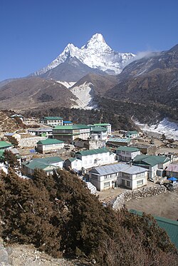
 Pangboche with Ama Dablam mountain behind | |
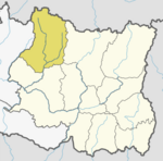
Location in Nepal | |
| Coordinates: 27°51′N 86°48′E / 27.850°N 86.800°E | |
| Country | |
| Province | Province No. 1 |
| Zone | Sagarmatha Zone |
| District | Solukhumbu District |
| Area | Khumjung |
| Elevation | 3,985 m (13,074 ft) |
| Time zone | UTC+5:45 (NST) |
Pangboche or Panboche is a village in Khumjung Village Development Committee of Solukhumbu District in Province No. 1 of Nepal at an altitude of 13,074 feet (3,985 m).[1] It is located high in the Himalayas in the Imja Khole valley, about 3 kilometres northeast of Tengboche and is a base camp for climbing the nearby Ama Dablam and trekking. It contains a monastery, famed for its purported yeti scalp and hand, the latter of which was stolen.[2] The village is inhabited mainly by Sherpas, and Sungdare Sherpa, a native of the village, held the record for summiting Everest five times in the Sherpa climbing history and in the world history of mountaineering in 1989.[3] The Pangboche school was built by Sir Edmund Hillary's Himalayan Trust in 1963. North of the village is the Dughla lake and pass.
See also[edit]
References[edit]
- ^ Deutschle, Phil (1 May 2012). The Two-Year Mountain: A Nepal Journey. Bradt Travel Guides. p. 107. ISBN 978-1-84162-385-6. Retrieved 13 May 2012.
- ^ Paris match. April 1973. Retrieved 13 May 2012.
- ^ Kunwar, Ramesh Raj (1989). Fire of Himal: an anthropological study of the Sherpas of Nepal Himalayan region. Nirala Publications. p. 100. Retrieved 13 May 2012.
External links[edit]


