
Tīnui: Difference between revisions
m Adding to Masterton District category |
Added External links section, incl commons category template and one external link |
||
| (14 intermediate revisions by 8 users not shown) | |||
| Line 1: | Line 1: | ||
{{Use dmy dates|date=July 2021}} |
|||
| ⚫ | |||
{{Use New Zealand English|date=July 2021}} |
|||
{{Infobox settlement |
|||
==School== |
|||
| name = Tīnui |
|||
Tinui Primary School is a small country school serving the Mangapakeha, Tinui, Annedale, Tinui Valley, Whakataki, Castlepoint and Mataikona areas. It is a decile 6 state school and has approximately 55 pupils.<ref>[http://www.tki.org.nz/Schools?school_name=Tinui&location=Masterton+District&schoolSearch=true&Search.x=0&Search.y=0 Te Kete Ipurangi] school profile.</ref> |
|||
| settlement_type = Locality |
|||
| ⚫ | |||
| image_caption = Tīnui Museum |
|||
| image_map = {{infobox mapframe|coord={{coord|40|52|40|S|176|04|20|E}}|zoom=9}} |
|||
| ⚫ | |||
| subdivision_type = [[List of sovereign states|Country]] |
|||
| subdivision_name = New Zealand |
|||
| subdivision_type1 = [[Regions of New Zealand|Region]] |
|||
| subdivision_name1 = [[Wellington Region]] |
|||
| subdivision_type2 = [[Territorial authorities of New Zealand|Territorial authority]] |
|||
| subdivision_name2 = [[Masterton District]] |
|||
| area_total_km2 = |
|||
| area_footnotes = |
|||
| population_total = |
|||
| population_footnotes = |
|||
| population_as_of = |
|||
| population_density_km2 = auto |
|||
}} |
|||
[[Image:CordylineAustralis.jpg|thumb|right|The Cabbage Tree, Tinui School's logo]] |
|||
| ⚫ | '''Tīnui''', also spelled '''Tinui''' and formerly spelled '''Tenui''', is a small village approximately 40 kilometres from [[Masterton]], in the [[Wairarapa]], New Zealand. The name comes from the [[Māori language|Māori]] words {{lang|mi|tī}}, [[Cabbage tree (New Zealand)|cabbage tree]], and {{lang|mi|nui}}, many.<ref>{{ReedPlacenames2002}}</ref> |
||
==History== |
==History== |
||
| ⚫ | |||
| ⚫ | Tīnui was the first place in New Zealand to have an [[ANZAC Day]] cross: On 25 April 1916, the local vicar led an expedition to place a large metal cross to commemorate the dead on Tīnui Taipo, a 360 m (1200 ft) high promontory behind the village, and a service was held.<ref>[http://www.nzhistory.net.nz/media/photo/tinui-war-memorial Tinui war memorial], New Zealand History online - Nga korero aipurangi o Aotearoa, History Group, Ministry for Culture and Heritage, Wellington, New Zealand. Updated 20 April 2007. Accessed 19 April 2009.</ref> In 2006, the 90th anniversary was commemorated with a 21-gun salute fired by soldiers from [[Waiouru Army Camp]]. In 2009, the [[Royal New Zealand Air Force|Air Force]] began promoting Tīnui as an alternative to travelling to [[Gallipoli]]. Veterans' Affairs Minister [[Judith Collins]] said of the promotion: "I would be delighted to see Tīnui become a place where people come to pay their respects and remember those who have fallen."<ref name="Stuff.co.nz_2343111">{{cite news |url=http://www.stuff.co.nz/national/2343111/Tiny-Tinui-proposed-as-our-new-Gallipoli |title=Tiny Tinui proposed as our 'new Gallipoli' |author=Katterns, Tanya |date=18 April 2009 |work=[[The Dominion Post (Wellington)|The Dominion Post]] |accessdate=23 November 2011}}</ref> |
||
| ⚫ | |||
| ⚫ | Tīnui has been flooded often, as it is situated on the river flats next to the confluence of the [[Whareama River]] and the [[Tīnui River]]. The first recorded flood was in 1858, when water covered the river flats. In 1936, floods caused thousands of sheep to drown and floodwaters reached a depth of 450 mm inside the Tīnui Hotel. The 1991 floods devastated the village when 200 mm of rain fell over a 24-hour period, and the river flooded again in July 1992.<ref>Casey, C. (1996) ''After the rains came : The Tinui Flood of April 1991''. Masterton District Library. {{ISBN|0-473-03793-9}}</ref> |
||
<gallery> |
<gallery> |
||
Tinui Taipo (22602504893).jpg| |
Tinui Taipo (22602504893).jpg|Tīnui Taipo |
||
Church of the Good Shepherd, Tinui (1902) August 2008 (2782726105).jpg|Church of the Good Shepherd |
Church of the Good Shepherd, Tinui (1902) August 2008 (2782726105).jpg|Church of the Good Shepherd |
||
The Cross, Tinui, Wairarapa (23203463736).jpg|The cross on the hill |
The Cross, Tinui, Wairarapa (23203463736).jpg|The cross on the hill |
||
Tinui, Wairarapa (22933825500).jpg|ANZAC walkway |
Tinui, Wairarapa (22933825500).jpg|ANZAC walkway |
||
| ⚫ | |||
Sheep puppies plus sheep mummy (3861278376).jpg |
|||
| ⚫ | |||
| ⚫ | |||
</gallery> |
</gallery> |
||
==Demographics== |
|||
Tīnui is part of the [[Whareama#Demographics|Whareama]] statistical area.<ref>{{NZ census place summary 2018|whareama|Whareama}}</ref> |
|||
==Education== |
|||
Tīnui School is a co-educational state primary school for Year 1 to 8 students from the Mangapakeha, Tīnui, Annedale, Tīnui Valley, Whakataki, [[Castlepoint]], and Mataikona areas.<ref name="moe3041">{{cite web |title=Ministry of Education School Profile |url=https://www.educationcounts.govt.nz/find-school/school/profile?school=3041 |website=educationcounts.govt.nz |publisher=[[Ministry of Education (New Zealand)|Ministry of Education]]}}</ref> It has a roll of {{NZ school roll data|3041|y}} as of {{NZ school roll data|||y|}}.<ref name="ero3041">{{cite web |title=Education Review Office Report |url=http://www.ero.govt.nz/report-view?id=3041 |website=ero.govt.nz |publisher=[[Education Review Office]]}}</ref> |
|||
== References == |
== References == |
||
{{ |
{{Reflist}} |
||
==External links== |
|||
{{commons category}} |
|||
* [https://www.mstn.govt.nz/community/the-masterton-district/townships/tinui Tīnui] at [[Masterton District Council]] |
|||
{{Masterton District, New Zealand}} |
|||
| ⚫ | |||
{{Authority control}} |
|||
[[Category:Populated places in the Wellington Region]] |
[[Category:Populated places in the Wellington Region]] |
||
Latest revision as of 23:44, 3 May 2024
Tīnui | |
|---|---|
Locality | |
.jpg) Tīnui Museum | |
 | |
| Coordinates: 40°52′40″S 176°04′20″E / 40.87778°S 176.07222°E | |
| Country | New Zealand |
| Region | Wellington Region |
| Territorial authority | Masterton District |

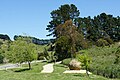
Tīnui, also spelled Tinui and formerly spelled Tenui, is a small village approximately 40 kilometres from Masterton, in the Wairarapa, New Zealand. The name comes from the Māori words tī, cabbage tree, and nui, many.[1]
History[edit]
Tīnui was the first place in New Zealand to have an ANZAC Day cross: On 25 April 1916, the local vicar led an expedition to place a large metal cross to commemorate the dead on Tīnui Taipo, a 360 m (1200 ft) high promontory behind the village, and a service was held.[2] In 2006, the 90th anniversary was commemorated with a 21-gun salute fired by soldiers from Waiouru Army Camp. In 2009, the Air Force began promoting Tīnui as an alternative to travelling to Gallipoli. Veterans' Affairs Minister Judith Collins said of the promotion: "I would be delighted to see Tīnui become a place where people come to pay their respects and remember those who have fallen."[3]
Tīnui has been flooded often, as it is situated on the river flats next to the confluence of the Whareama River and the Tīnui River. The first recorded flood was in 1858, when water covered the river flats. In 1936, floods caused thousands of sheep to drown and floodwaters reached a depth of 450 mm inside the Tīnui Hotel. The 1991 floods devastated the village when 200 mm of rain fell over a 24-hour period, and the river flooded again in July 1992.[4]
-
 Tīnui Taipo
 -
 Church of the Good Shepherd
 -
 The cross on the hill
 -
 ANZAC walkway
 -
 Tīnui Hotel
.jpg)
_August_2008_(2782726105).jpg)
.jpg)
.jpg)

Demographics[edit]
Tīnui is part of the Whareama statistical area.[5]
Education[edit]
Tīnui School is a co-educational state primary school for Year 1 to 8 students from the Mangapakeha, Tīnui, Annedale, Tīnui Valley, Whakataki, Castlepoint, and Mataikona areas.[6] It has a roll of 36 as of February 2024.[7]
References[edit]
- ^ Reed, A.W. (2002) The Reed dictionary of New Zealand place names. Auckland: Reed Books. ISBN 0-790-00761-4.
- ^ Tinui war memorial, New Zealand History online - Nga korero aipurangi o Aotearoa, History Group, Ministry for Culture and Heritage, Wellington, New Zealand. Updated 20 April 2007. Accessed 19 April 2009.
- ^ Katterns, Tanya (18 April 2009). "Tiny Tinui proposed as our 'new Gallipoli'". The Dominion Post. Retrieved 23 November 2011.
- ^ Casey, C. (1996) After the rains came : The Tinui Flood of April 1991. Masterton District Library. ISBN 0-473-03793-9
- ^ 2018 Census place summary: Whareama
- ^ "Ministry of Education School Profile". educationcounts.govt.nz. Ministry of Education.
- ^ "Education Review Office Report". ero.govt.nz. Education Review Office.
External links[edit]
| International | |
|---|---|
| National | |