
User:Britmax/Workshop and Eglinton Tournament Bridge: Difference between pages
Proto Diagram |
Rosser1954 (talk | contribs) |
||
| Line 1: | Line 1: | ||
{{Infobox Bridge |
|||
This is a Workshop for work in progress. Any work in a finished state should go to the [[User:Britmax/Warehouse|Warehouse]]. |
|||
|bridge_name = Eglinton Tournament Bridge |
|||
|image = Eglintoncastle1876.jpg |
|||
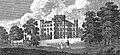
|caption = Tournament Bridge and castle in 1876<ref name="Dobie">Dobie, James (1876). ''Pont's Cuninghame'' Pub. John Tweed.</ref> |
|||
|official_name = Tournament Bridge |
|||
|carries = Pedestrians |
|||
|crosses = [[Lugton Water]] |
|||
|locale = [[Eglinton Country Park]] |
|||
|maint = [[North Ayrshire Council]]<br>[[Historic Scotland]] |
|||
|id = |
|||
|design = Gothic |
|||
|mainspan = |
|||
|length = |
|||
|width = |
|||
|height = |
|||
|load = |
|||
|clearance = |
|||
|below = |
|||
|traffic = |
|||
|begin = |
|||
|complete = |
|||
|open = c. 1845 |
|||
|closed = |
|||
|toll = |
|||
|map_cue = |
|||
|map_image = |
|||
|map_text = |
|||
|map_width = |
|||
|coordinates = {{coord|55.6446|-4.6699|type:landmark_region:GB|display=inline,title}} |
|||
}} |
|||
The '''Eglinton Tournament Bridge''' is a [[bridge]] located within [[Eglinton Country Park]] near [[Kilwinning]], [[North Ayrshire]], [[Scotland]]. The bridge crosses the [[Lugton Water]] a short distance northwest of [[Eglinton Castle]] (OS ref: {{oscoor|NS32064224|NS32064224}}) and was named after the [[Eglinton Tournament of 1839]]. The castle and surrounding grounds were once home to the Montgomerie family, [[Earl of Eglinton|Earls of Eglinton]] and chiefs of the [[Clan Montgomery]]. |
|||
== History == |
|||
{{See also|Eglinton Castle}} |
|||
====The Tournament Bridges==== |
|||
The surviving Tournament Bridge was built to provide an appropriate crossing point to gain access to the far side of the [[Lugton Water]]. [[Archibald Montgomerie, 13th Earl of Eglinton|Archibald Montgomerie]], the 13th [[Earl of Eglinton]] had the bridge built in a [[Gothic architecture|Gothic]] style, using cast iron for the arches, pinnacles, etc. and stone for the two pairs of miniature ornamental towers at either end. These towers have subtle design differences (See photographs) which are significant in the context of the extended history of the bridge. This 'Tournament' bridge was designed by the architect [[David Hamilton (architect)|David Hamilton]]. The bridge's cast iron [[parapet]] is a repetition of the pointed Gothic arch design of the castle, surmounted by a battlement, and relieved in the centre with foliated [[pinnacle]]s.<ref name="Millar">Millar, A. H. (1885). ''The Castles and Mansions of Ayrshire.' Reprinted by The Grimsay Press (2004). ISBN 1-84530-019x. P. 74.</ref> The Tournament Bridge is B listed by [[Historic Scotland]].<ref name="Historic">[http://www.historic-scotland.gov.uk/gardens_search_more_info.htm?s=eglinton+castle&r=Glasgow%2c+Clyde+and+Ayrshire&bool=1&PageID=2374&more_info=Site Historic gardens]</ref> |
|||
[[Image:Eglinton Tournament Bridge and procession in 1839.jpg|left|thumb|<Center>The original Tournament Bridge and the procession in 1839. Note the three cast iron arches, crossed finials, pinnacles, and the taller, broader towers, etc. characteristic of that bridge.<ref name="Aikman">Aikman, James (1839). ''An account of the tournament at Eglinton, revised and corrected by several of the knights : with a biographical notice of the Eglinton family to which is prefixed a sketch of chivalry and of the most remarkable Scottish tournaments.'' Pub. Edinburgh : H. Paton, Carver and Gilder. Facing P. 4.</ref>]] |
|||
[[Image:A map of the Eglinton Tournament features.jpg|right|thumb|<Center>A map showing the layout of the various features associated with the Eglinton Tournament. Note the lakes either side of the bridge<ref name="Tait">Tait's Edinburgh Magazine. November 1839.</ref>, formed around 1800.<ref name="Stoddart">Stoddart, John (1801). ''Remarks on Local Scenery and Manners in Scotland during the years 1799 and 1800.'' Pub. William Miller, London. P. 313.</ref>]] |
|||
{|{{Railway line header}} |
|||
{{UKrail-header|Telescope}} |
|||
{{BS-table}} |
|||
{{BS5|||exAKRZ-UKu|LUECKE||[[M11 motorway|M11]]|||}} |
|||
{{BS5|||exLUECKE|LUECKE|||||}} |
|||
{{BS5|||uENDEa|LUECKE||Note: Alignment west of Cambridge partially taken||}} |
|||
{{BS5|||uSTR|LUECKE||over by [[Mullard Radio Astronomy Observatory]]'s }} |
|||
{{BS5|||uSTR|LUECKE||moving telescope}} |
|||
{{BS5|||uSTR|LUECKE||}} |
|||
{{BS5|||uENDEe|LUECKE|||||}} |
|||
{{BS5|||exLUECKE|LUECKE|||||}} |
|||
{{BS5|||exHST|LUECKE||[[Lord's Bridge railway station|Lord's Bridge]]|||}} |
|||
{{BS5|||exHST|LUECKE||[[Old North Road railway station|Old North Road]]|||}} |
|||
|} |
|||
|} |
|||
The [[1839]] Eglinton Tournament was held on a meadow or holm at a loop in the Lugton Water. Most of the holm no longer exists, the excavations in this area having provided gravel and sand for the construction of the Kilwinning bypass and leaving behind an excavation pit which is now known as Eglinton Loch. The Knights on horseback and their retinue reached the [[Tiltyard|tilt yard]] ('C' on the map) via an enclosed ride ('G' on the map), whilst the guests and visitors made their way to the stands via the route marked 'F' on the map illustrated. Both groups crossed over the previous three arched Gothic bridge. A map of 1837 of ''Eglinton Castle, Grounds and Tilt yard'' of 1837 shows that the tilt yard was already in extistence at this early date, but it is not recorded what its fate was after the tournament was over.<ref name="Anstruther">Anstruther, Ian (1986). ''The Knight and the Umbrella. An Account of the Eglinton Tournament 1839''. Pub. Alan Sutton. Gloucester. ISBN 0-86299-302-4. P. III.</ref> |
|||
{|{{Railway line header}} |
|||
{{UKrail-header|Aberdeen to Inverness Line|#ffe02b}} |
|||
{{BS-table}} |
|||
{{BS3||LUECKE|||''( [[Kyle Line]] [[Far North Line| and Far North Line]] )''}} |
|||
{{BS3|BHFr|ABZrd|||[[Inverness railway station|Inverness]]}} |
|||
{{BS3|HLUECKE|ABZrf|||''[[Highland Main Line]]''}} |
|||
{{BS3||BHF|||[[Nairn railway station|Nairn]]}} |
|||
{{BS3||BHF|||[[Forres railway station|Forres]]}} |
|||
{{BS3|LUECKE|BHF|||[[Elgin railway station|Elgin]]}} |
|||
{{BS3|KBFe|STR|||[[Keith Town railway station|Keith Town]]}} |
|||
{{BS3|exSTRlf|eABZlg|||''[[Keith and Dufftown Railway]]''}} |
|||
{{BS3||BHF|||[[Keith railway station|Keith]]}} |
|||
{{BS3||BHF|||[[Huntly railway station|Huntly]]}} |
|||
{{BS3||BHF|||[[Insch railway station|Insch]]}} |
|||
{{BS3||BHF|||[[Inverurie railway station|Inverurie]]}} |
|||
{{BS3|FLUG|BHF|||[[Dyce railway station|Dyce]]}} |
|||
{{BS3||STR|||[[Aberdeen Airport|(for Aberdeen Airport)]]}} |
|||
{{BS3||BHF|||[[Aberdeen railway station|Aberdeen]]}} |
|||
{{BS3||LUECKE||||''[[Edinburgh to Aberdeen Line]]''}} |
|||
|} |
|||
|} |
|||
[[Image:Eglinton Castle & Tournament Bridge 1884.jpg|thumb|left|<center>The castle and Tournament Bridge in 1884.]] |
|||
==Aberdeen-Inverness Line== |
|||
The 'new' Tournament Bridge served as a well used route across the Lugton Water, running through the deer park to the Eglinton kennels (previously Laigh Moncur), especially on days when the Eglinton Hunt met at the castle itself. |
|||
{|{{Railway line header}} |
|||
[[Image:Eglinton Tournament Bridges compared.jpg|right|thumb|<Center>The 'old' Tournament Bridge converted artificially to two arches, etc for comparison.]] |
|||
{{UKrail-header|Aberdeen-Inverness Line|#ffe02b}} |
|||
The original bridge, also with two miniature towers, but with three arches and four pinnacles, stood roughly 100 yards further up the river towards the castle,<ref name="Ness3">Ness, J. A. (1969 - 70). Landmarks of Kilwynnyng. Privately produced. P. 29.</Ref> as shown in several contemporary prints and maps as illustrated in the appropriate gallery of this article.<ref name="Aitkenmap">Aitken, Robert (1829). ''The Parish Atlas of Ayrshire - Cunninghame.'' Pub. W. Ballantine. Edinburgh.</ref> It was this bridge that was used at the Eglinton Tournament as can be seen from the illustrations of the event, however the name was passed on to the 'new' bridge constructed downstream of it. No clear sign of this three arched bridge remains, a weir having been built at its old position; the 'old' bridge was constructed in 1811<ref name="Close">Close, Rob (1992), ''Ayrshire Buildings.'' Royal Incorporated Architects of Scotland. ISBN 1873-190-069. P. 64.</ref><ref name="Ayrshire Roots">[http://www.ayrshireroots.co.uk/Towns/Kilwinning/Kilwinning%20Historical%20Timeline.htm Ayrshire Roots]</ref>, therefore around the time of the 'new' castle being built in 1801/2 and also when the grounds were being laid out by Tweedie. |
|||
{{BS-table}} |
|||
{{BS3||LUECKE|||''( [[Kyle Line]] [[Far North Line| and Far North Line]] )''}} |
|||
{{BS3|BHFr|ABZrd|||[[Inverness railway station|Inverness]]}} |
|||
{{BS3|HLUECKE|ABZrf|||''[[Highland Main Line]]''}} |
|||
{{BS3||STR|||([[Millburn Junction]])}} |
|||
{{BS3||eHST|||[[Allanfearn railway station|Allanfearn]]}} |
|||
{{BS3||eHST|||[[Castle Stuart Platform railway station|Castle Stuart Platform]]}} |
|||
{{BS3||eHST|||[[Dalcross railway station Dalcross|Dalcross railway station Dalcross]]}} |
|||
{{BS3||eABZrg|exHLUECKE||''[[Fort George railway station|to Fort George]]''}} |
|||
{{BS3||eBHF|||[[Gollanfield Junction railway station|Gollanfield Junction]]}} |
|||
{{BS3||BHF|||[[Nairn railway station|Nairn]]}} |
|||
{{BS3||eHST|||[[Auldearn railway station|Auldern]]}} |
|||
{{BS3||eHST|||[[Brodie railway station|Brodie]]}} |
|||
{{BS3||STR|||}} |
|||
{{BS3|STRrg|xABZrf||}} |
|||
{{BS3|BHF|exSTR|||[[Forres railway station|Forres]]}} |
|||
{{BS3|xABZlf|xABZlg|||}} |
|||
{{BS3|exLUECKE|STR|||[[Aviemore railway station| to Aviemore]] [[Strathspey Railway|via Strathspey Railway]]}} |
|||
{{BS3||eBHF|||[[Kinloss railway station|Kinloss]]}} |
|||
{{BS3||eABZlf|exHLUECKE||[[Findhorn railway station|to Findhorn]]}} |
|||
{{BS3||eABZrg|exHLUECKE||''[[Burghead railway station | to Burghead]]''}} |
|||
{{BS3||eBHF|||[[Alves railway station|Alves]]}} |
|||
{{BS3||eHST|||[[Mosstowie railway station|Mosstowie]]}} |
|||
{{BS3||BHF|||[[Elgin railway station|Elgin]]}} |
|||
{{BS3||eABZlf|exSTRlg||}} |
|||
{{BS3|exHLUECKE|eKRZu|exABZrf||'' [[Rothes railway station| to Rothes]][[Dufftown railway station| and Dufftown]]''}} |
|||
{{BS3||STR|exLUECKE||''[[Lossiemouth railway station| to Lossiemouth]]''}} |
|||
{{BS3||STR|||}} |
|||
{{BS3||eABZrg|exHLUECKE||''[[Fochabers railway station|to Fochabers]]''}} |
|||
{{BS3||eBHF|||[[Orbliston Junction railway station|Orbliston Junction]]}} |
|||
{{BS3||eBHF|||[[Orton railway station|Orton]]}} |
|||
{{BS3|exHLUECKE|eABZrf|||''[[Rothes railway station|to Rothes]]''}} |
|||
{{BS3||STR|||}} |
|||
{{BS3||eHST|||[[Mulben railway station|Mulben]]}} |
|||
{{BS3||eHST|||[[Tauchers Platform railway station|Tauchers Platform]]}} |
|||
{{BS3|LUECKE|eABZrg|exHLUECKE||''[[Buckie railway station|to Buckie]]''}} |
|||
{{BS3|STRlf|ABZlg|||''[[Keith and Dufftown Railway]]''}} |
|||
{{BS3||BHF|||[[Keith railway station|Keith]]|}} |
|||
{{BS3||eBHF|||[[Grange railway station|Grange]]|}} |
|||
{{BS3||eABZld|exHLUECKE||[[Banff railway station|to Banff]]|}} |
|||
{{BS3||eBHF|||[[Cairnie Junction railway station|Cairnie Junction]]|}} |
|||
{{BS3||eHST|||[[Rothiemay railway station|Rothiemay ]]}} |
|||
{{BS3||BHF|||[[Huntly railway station|Huntly]]}} |
|||
{{BS3||eHST|||[[Gartley railway station|Gartley]]}} |
|||
{{BS3||eHST|||[[Kennethmont railway station|Kennethmont ]]}} |
|||
{{BS3||eHST|||[[Wardhouse railway station|Wardhouse ]]}} |
|||
{{BS3||BHF|||[[Insch railway station|Insch]]}} |
|||
{{BS3||eHST|||[[Buchanstone railway station|Buchanstone]]}} |
|||
{{BS3||eHST|||[[Oyne railway station|Oyne ]]}} |
|||
{{BS3||eHST|||[[Pitcaple railway station|Pitcaple ]]}} |
|||
{{BS3||eABZrg|exHLUECKE||[[Macduff railway station| to Macduff]]}} |
|||
{{BS3||eBHF|||[[Inveramsey railway station|Inveramsey]]}} |
|||
{{BS3||eABZrg|exHLUECKE||[[Oldmeldrum railway station| to Oldmeldrum]]}} |
|||
{{BS3||BHF|||[[Inverurie railway station|Inverurie]]}} |
|||
{{BS3||eDST|||[[Port Elphinstone Goods Depot|Port Elphinstone]]}} |
|||
{{BS3|exHLUECKE|eABZlg|||''[[Alford railway station| to Alford]]''}} |
|||
{{BS3||eBHF|||[[Kintore railway station|Kintore]]|}} |
|||
{{BS3||eHST|||[[Kinaldie railway station|Kinaldie ]]}} |
|||
{{BS3||eHST|||[[Pitmeddan railway station|Pitmeddan ]]}} |
|||
{{BS3||eABZrg|exHLUECKE||''to [[Peterhead railway station|Peterhead]] [[Fraserburgh railway station| and Fraserburgh]]''}} |
|||
{{BS3|FLUG|BHF|||[[Dyce railway station|Dyce]]}} |
|||
{{BS3||STR|||[[Aberdeen Airport|(for Aberdeen Airport)]]}} |
|||
{{BS3||eHST|||[[Staleywood railway station|Staleywood ]]}} |
|||
{{BS3||eHST|||[[Bankhead railway station|Bankhead ]]}} |
|||
{{BS3||eHST|||[[Bucksburn railway station|Bucksburn ]]}} |
|||
{{BS3||eHST|||[[Persley railway station|Persley ]]}} |
|||
{{BS3||eHST|||[[Woodside (Aberdeen) railway station|Woodside ]]}} |
|||
{{BS3||eHST|||[[Don Street railway station|Don Street ]]}} |
|||
{{BS3||eABZlf|exSTRlg||}} |
|||
{{BS3||eBHF|exBHF||[[Kittybrewster railway station|Kittybrewster (new and old stations)]]}} |
|||
{{BS3||STR|exKBFe||[[Aberdeen Harbour railway station|Aberdeen Harbour]]}} |
|||
{{BS3||BHF|||[[Aberdeen railway station|Aberdeen]]}} |
|||
{{BS3|exHLUECKE|eABZrf|||''[[Royal Deeside Railway| to Royal Deeside Railway]]''}} |
|||
{{BS3||LUECKE||||''[[Edinburgh to Aberdeen Line]]''}} |
|||
|} |
|||
|} |
|||
Surviving architects drawings show the designs for a three arched bridge and as stated, contemporary prints of the Eglinton Tournament also show a three arched Tournament bridge, with cast iron arches, pinnacles and parapets which may have been re-used in the later 'new' bridge which survives today. |
|||
The point at which the 'old' bridge crossed the Lugton was 102 feet broad and 100 yards downriver from the castle.<ref name="Aiton2">Aiton, William (1811). Extract from the General View of the Agriculture of Ayr.</ref> It had the Montgomerie coat of arms in the centre. Aiton describes it as being under construction in 1811.<ref name="Aiton">Aiton, William (1811). Extract from the General View of the Agriculture of Ayr.</ref> The miniature castle towers on the demolished bridge are shown as each being surmounted by a double cross, but these do not figure on the 'new' Tournament Bridge; the 'old' bridge therefore may have been specially embellished for the tournament with temporary additions. |
|||
[[Image:Rebuilt Tournament Bridge.jpg|left|thumb|<Center>A view of the Tournament Bridge at its 'new' site. The level of the weir was lower at this time and was raised at a later date using randomly chosen stones to raise the water level.<ref name="NAC5">North Ayrshire Council, Roads and Transportation services. 2008</ref>]] |
|||
[[Image:Lord of the Tournament & his esquires & retainers.JPG|right|thumb|<center>The Lord of the Tournament (Earl of Eglinton) and his esquires and retainers crossing the bridge.<ref name="Hodgson">''The Eglinton Tournament.'' Pub. Hodgson & Graves. London. 1840. P. 6.</ref>]] |
|||
A local minister, the Rev. Lee Ker, confirms which bridge was used at the tournament by relating in his book on [[Kilwinning]] that the tournament procession passed over the Water of Lugton by ''what is now called the Tournament Bridge, but which was then situated about 100 yards nearer the Castle and had three arches instead of two.''<ref name="Ker">Ker, Rev William Lee (1900). ''Kilwinning'' Pub. A. W. Cross, Kilwinning. P. 326.</ref> This distance coincides with a weir today and an old path from the castle leads directly to it. Dane Love states that the bridge used by the tournament had been built by the 12th Earl in 1811.<ref name="Love">Love, Dane (2003). ''Ayrshire: Discovering a County.'' Pub. Fort. Ayr. ISBN 0-9544461-1-9. P. 54.</ref> In contemporary reports of the tournament no special mention of the bridge is made, suggesting that it was already a well established feature of the estate by that time and not an extravagant new feature specially built for the event. |
|||
Lauchlan<ref name="Lauchlan">Lauchlan, Roy (1989). ''Questions & Answers about the Montgomerie Family and the 1839 Tournaments.'' Pub. Kilwinning & District Preservation Society. P. 12.</ref> confuses the issue by stating that an older bridge with three arches existed 100 yards up from the present one, however he states that the present bridge was built for the tournament. The old three arched bridge in fact still existed in 1840<ref name="Leighton2">Leighton, John M. (1850).''Strath Clutha or the Beauties of the Clyde.'' Pub. Joseph Swan Engraver. Glasgow. Facing P. 229.</ref> and at least as late as 1843.<ref name="Wreath2">''The Ayrshire Wreath MDCCCXLIII (1843): a collection of original pieces, in prose and verse, chiefly by native authors, on subjects relating to Ayrshire.'' Pub. H. Crawford & Son. Kilmarnock. Facing Title page.</ref> |
|||
{{Clear}} |
|||
http://archive.thisishampshire.net/2005/1/14/14934/html |
|||
====Construction of the 'new' Tournament Bridge==== |
|||
==West Somerset Mineral Railway Refs== |
|||
The new bridge may have been erected by the 13th Earl at some time between 1843 and 1856 as part of the total re-modelling of the course of the Lugton Water which had been first undertaken by the 12th Earl (1740 - 1819)<ref name="IDC276">''Landscape of the Knights. The Eglinton Story.'' Rub. Irvine Development Corporation. 1992. P. 27.</ref> and which included the alteration of its course, the removal of the lakes or ponds and the creation of several weirs. The Lugton Water is liable to severe floods<ref name="Archive">The Eglinton Archive.</ref> and damage to the easily broken cast iron work by the force of the current, may have been a reason for its reconstruction at a different site. The first [[Ordnance Survey]] map of 1856 shows the two arched bridge in position, a weir at the position of the old bridge and by this time the old lake had gone, replaced by a canalised Lugton Water with several weirs. |
|||
[[Image:Robertsonscunn2.jpg|right|thimb|200px|<Center>Robertosn's Map of the 1820s showing a lochan at Eglinton Castle.]] |
|||
Ironically the strengthening work done on the 'new' bridge to produce an extra arch of bricks in addition to the cast iron, may have weakened the structure, contributing to its eventual partial collapse.<ref name="NAC4">North Ayrshire Council, Roads and Transportation services. 2008</ref> The army used the bridge extensively with large lorries and even tanks crossong over it. |
|||
The lower courses of ashlar<ref name="Ashlar">[http://en.wikibooks.org/wiki/A_Researcher%27s_Guide_to_Local_History_Terminology - Ashlar]</ref> on the bridge abutments and central pier were vermiculate.<ref name="Vermiculate">[http://en.wikibooks.org/wiki/A_Researcher%27s_Guide_to_Local_History_Terminology - Vermiculate stonework]</ref> At some point the height of the weir beneath had been raised using an odd assortment of re-used stonework; this would have increased the depth and extent of the waters behind it. The central pier and the original weir had used reworked but re-cycled stone, probably from Kilwinning Abbey; as illustrated by a stone window surround recovered during restoration work (See illustration). |
|||
[[West Somerset Mineral Railway]] |
|||
[http://www.irsociety.co.uk/Archives/26/WSMR.htm] |
|||
[http://www.subbrit.org.uk/sb-sites/stations/w/watchet/index.shtml] |
|||
Examination of the top of the outer towers shows that something was attached to the centres, the 'plug' hole still being present. It is possible that the holes are relate dto the method of lifting them into position during construction work. The larger towers are capped with cement and nothing is therefore visible. During restoration work (2008) electricity power cables or possibly gas pipes were located leading to the bridge and they may have served lights on top of some or all of the towers.<ref name="NAC6">North Ayrshire Council, Roads and Transportation services. 2008</ref> These are not visible in the available illustrations. The [[Eglinton Country Park|Eglinton estate]] had its own gasworks and later its own power station, so it would have been natural to provide lighting on the bridge. The old [[Ordnance Survey|OS maps]] show that by 1897 the gas works had been established here to supply the castle and offices, whilst by 1911 this had been replaced by an electricity works; the present day park workshop. |
|||
[[Image:Numbered section cast iron arch.JPG|left|thumb|200px|<center>Numbering on the cast iron arch sections.]] |
|||
The larger and taller inner towers appear to have been re-used from the older bridge, this being confirmed by the presence of ornate carving which is now obscured by the low wall leading to them from the smaller towers. The curtain walls and the smaller and lower outer towers are made from a different type of stone and, as stated, the towers have a number of architectural differences, suggesting that they were made specifically for the 'new' Tournament Bridge (See photographs). During work on the central pier it was found that some of the hidden infill work is vermiculate ashlar from the 'old' bridge. |
|||
==Luckford Lake is Purbeck's Boundary refs== |
|||
The cast iron sections of the arches are numbered and some of the sequence are absent, suggesting that these missing sections may have been damaged previously beyond repair and were not used therefore in the 'new' bridge. |
|||
:http://www.isleofpurbeck.com/ |
|||
:http://www.users.waitrose.com/~langtonmatravers/location.html |
|||
{{Clear}} |
|||
=== Older bridges gallery === |
|||
<gallery> |
|||
Image:Eglinton Castle and wooden bridge. 1815..jpg|<Center>A view of the castle and a wooden footbridge in 1815. |
|||
Image:Eglinton Castle Bridge of 1815.jpg|<Center>Details of the wooden bridge. |
|||
Image:Eglinton Castle, Irvine, circa 1840.jpg|<Center>The castle and bridge in 1815. Three arches and a lake are depicted. |
|||
Image:Eglinton tournament bridge in 1843.jpg|<Center>Eglinton Castle & Bridge. This again shows the original three arched bridge, lake, etc. Circa 1843.<ref name="Wreath">''The Ayrshire Wreath MDCCCXLIII (1843):a collection of original pieces, in prose and verse, chiefly by native authors, on subjects relating to Ayrshire.'' Pub. H. Crawford & son. Kilmarnock. Facing Title page</ref> |
|||
</gallery> |
|||
=== The 'new' Tournament Bridge === |
|||
==Somerset and Dorset The Line Today== |
|||
<gallery> |
|||
Image:Restored Tournament Bridge 1980.jpg|<Center>The Tournament bridge as restored in the 1980s. |
|||
Image:Tournament bridge in flood conditions.jpg|<Center>Flood conditions. |
|||
Image:Eglintontournamentbridge.JPG|<center>The Tournament Bridge over the Lugton Water in 2007. |
|||
Image:Tournamentbridge2.JPG|<center>The approach to the Tournament Bridge from the stables in 2007. |
|||
Image:Tournament Bridge benchmark.JPG|<Center>A [[benchmark]] on one of the bridge towers. |
|||
Image:Large Tournament bridge tower.JPG|<Center>One of the large bridge towers, probably recycled from the 1811 bridge. |
|||
Image:Small tournament bridge tower.JPG|<Center>One of the smaller towers with subtle design and carving differences suggesting a later date of construction. |
|||
Image:Vermiculate ashlar stonework Tournament Brdige.JPG|<Center>Vermiculate ashlar stonework on the abutment of the bridge at water level. |
|||
Image:Recycled stone Tournament Bridge.JPG|<Center>A reworked stone window ledge, possibly from Kilwinning Abbey, used in the weir at the central pier. |
|||
Image:Eglinton Tournament Bridge construction details.jpg|<Center>Details of how one of the recycled towers has been incoroprated into the new design. |
|||
Image:Hydrodemolition damage.JPG|<center>Hydrodemolition damage to the central pier. |
|||
Image:Recycled bridge stone.JPG|<Center>Recycled stones built into the weir beneath the bridge. One has the remains of two [[Corbel|corbels]] and may well have come from the pre-1802 medieval castle. |
|||
Image:Mason's mark.JPG|<Center>A Mason's Mark on the corbelled stone. |
|||
Image:Tournament Bridge piers.JPG|<Center>A cut water, possibly from the 'new bridge,' but removed during the 'army works.' |
|||
Image:Tournament Bridge old tower section.JPG|<Center>A section of an 'old' bridge tower used in the weir. |
|||
Image:Tournament Bridge weir.JPG|<Center>The weir made from sections of the old large 'towers.' |
|||
</gallery> |
|||
== The Tournament Bridge and WWII == |
|||
From North to South |
|||
The Eglinton Castle Estate was requisitioned during [[World War II]] and during this occupation the Tournament Bridge partly collapsed, partly due to alterations which had been made earlier by the Eglinton Estate, involving supposed strengthening using brickwork, as revealed during the 2008 restoration work.<ref name="NAC2">North Ayrshire Council, Roads and Transportation services. 2008</ref> The bridge was never designed to take the heavy army lorries and tanks which used the bridge during the army occupation of the site and this led to a partial collapse in the 1940s. To save the bridge from total collapse the army Royal Engineers Regiment removed the cast iron outer facia coverings and the pinnacles, encasing the remaining cast iron arches in concrete as can be seen from contemporary photographs and as further revealed during restoration work. It is not known what happened to the pinnacles and cast iron coverings. It had been thought that they were safely in storage, however enquiries have led to nothing.<ref name="NAC2">North Ayrshire Council, Roads and Transportation services. 2008</ref> |
|||
==== Repair work ==== |
|||
Bath Green Park is a shopping area and arts space, with a Sainsbury's supermarket where the MPD was. The two tunnels are planned to be part of a path as the route is clear. |
|||
<gallery> |
|||
The trackbed near Cock Mill Crossing, between the sites of Pylle and West Pennard stations, crosses the site of the [[Glastonbury Festival]] and functions as an internal road within the festival site. There are gates at both points where it crosses the perimeter fence. |
|||
Image:Tournament Bridge collapse, Eglinton Estate, Ayrshire.jpg|A view showing the partial collapse of the bridge. |
|||
Between Corfe Mullen and Broadstone the former ttrack is part of the golf course. The cutting at Corfe Mullen has been filled in. |
|||
Image:Tournament Bridge, Eglinton Estate, Ayrshire in the 1930s.jpg|Repair work underway, showing the shuttering for the concrete. |
|||
The route between Broadstone and Holes bay Junction was used for the Broadstone Way and Holes Bay relief roads in the 1980's. |
|||
Image:Tournament Bridge repaired, Eglinton, Ayrshire.jpg|The repaired bridge. Note the simple wooden handrail and the remaining exposed iron arch. |
|||
Image:Tournament Bridge repaired, Eglinton Estate, Ayrshire.jpg|A view of the whole of the repaired bridge. Note the army personnel and lots of children fishing, etc. |
|||
Dates for paragraph below[http://www.semg.org.uk/proto/contbrnat.html] |
|||
</gallery> |
|||
The Transport Act passed on 6 August 1947 nationalising the railways became effective on 1 January 1948. On that date the Somerset and Dorset Railway services were jointly run by BR(S) and BR Midland Region (BR(M)) then latterly BR Western Region (BR(W)) until closure. |
|||
== Other estate bridges == |
|||
[[Image:Ainslie's Eglinton in 1790.JPG|left|thumb|<center>John Ainslie's 1790 map showing pleasure garden on the opposite side of the Lugton Water to the castle in what became part of the deer park.]] |
|||
[[Image:Eglinton in 1790.JPG|right|thumb|<center>John Ainslie's 1790 map showing pleasure garden on the opposite side of the Lugton Water to the castle in what became part of the deer park.]] |
|||
Originally the river would have been crossed by simple fords, however by the 18th century ornamental pleasure gardens had been formed and these were partly situated in what later became the deer park. No signs of these gardens are now visible, apart from [[Crop mark]]s on aerial photographs taken around the end of the Second World War. A bridge was necessary to give access to the ornamental gardens and one is indicated on John Ainslie's map dated 1790, crossing the Lugton Water close to the castle itself. A small wooden bridge across the Lugton Water is shown in an illustration from around 1815, however this may not have been across the Lugton Water. Thomson's map of 1828 (See illustration) indicates a bridge crossing the Lugton Water at the castle where the three arched bridge was and a drive starting off at the position of the present day bridge, which may have been a ford at the time. Another bridge is suggested further upstream and close to the castle.<ref name="Thomson">Thomson, John (1828). A Map of the Northern Part of Ayrshire.</ref> The wooden Laundry Bridge stood close to the castle and downstream from it was second wooden bridge which was washed away in a storm in 1938. Local children used it to build rafts. |
|||
[[Image:William Roy, Eglinton, 1747 - 55.jpg|left|200px|thumb|<Center>William Roy's 1747 - 55 map<ref name=Roy">Roy, William (1747 - 55) Military Map of Scotland.</ref> showing a bridge only upstream of the castle, roughly where Thomson also shows a bridge in his 1828 map.]] |
|||
[[Image:Eglinton by John Thomson 1828.jpg|right|thumb|200px|<Center>John Thomson's 1828 map showing the position of the old Tournamaent bridge. Here a drive and a possible building are located at the site of the 'new' Tournament Bridge.<ref name="Thomson">Thomson, John (1828). A Map of the Northern Part of Ayrshire.</ref>]] |
|||
The restored Stables Bridge, also called Lady Jane's Bridge, lies on the Kilwinning Lodge drive and just downstream from it stood an elegant cast-iron bridge with a 50 foot span.<ref name="Aiton2">Aiton, William (1811). Extract from the General View of the Agriculture of Ayr.</ref> This bridge had high quality stonework on both of the abutments, much of which survive. This bridge gave access to the kitchen walled gardens and glasshouse ranges and lasted into the mid 1940s when the army removed it. |
|||
The Suspension Bridge built by the army in the 1980s on behalf of the country park lies just below the weir beside the ruined gazebo. Lady Jane's cottage had a wooded pedestrian footbridge of which no sign remains. |
|||
The recent addition of Ordnance Survey in the External Links section of some of the articles to which I have added diagrams may cause queries. I have no link with OS other than, as the saying has it, as a satisfied customer of long standing. |
|||
However, I frequently use the OS site to check various geographical information before putting it on the diagrams I add to railway line articles. This to me means that the OS map site is a source and should be mentioned in supporting notes for the article concerned. [[User:Britmax|Britmax]] 09:48, 2 May 2007 (UTC) |
|||
The restored Diamond Bridge lies upstream near the Eglinton Loch and continues to give access to the old Toll Road from Irvine to Kilwinning via [[Fergushill]]. This bridge was named after the nearby Black Diamond mine, the spoil heap or bing of which still remains rear the Chapelholm Gate. The colliery name in turn was associated with one of the 13th Earl's favourite horses, Black Diamond. |
|||
Hi Britmax, you can cite sources using the system described at [[WP:CITE]]: |
|||
{{Clear}} |
|||
== A Gallery of the other bridges == |
|||
After the sentence/paragraph/diagram being referenced add <nowiki><ref>Name of reference here</ref></nowiki> |
|||
<gallery> |
|||
Image:Lugtoneglintonbridge.JPG|<center>The suspension bridge over the Lugton Water. |
|||
Image:The Eglinton Suspension Bridge.JPG|<Center>The suspension bridge and cascade weir. |
|||
Image:Eglinton Lady Jane's cottage.jpg|<center>Lady Jane's cottage with its footbridge across the Lugton Water. |
|||
Image:Diamond Bridge restoration.jpg|<Center>The Diamond Bridge undergoing restoration. |
|||
Image:Eglinton Chapelholms bridge.JPG|<center>The Chapelholm or 'Diamond' bridge. |
|||
Image:Eglinton stables bridge.JPG|<center>The Stable's Bridge. |
|||
Image:Abutment of bridge in Eglinton.JPG|<Center>An abutment of the old Walled Garden bridge. Iron work is embedded in the structure, which was faced with high quality vermiculate ashlar stonework. |
|||
Image:Stucco stone from footbridge.JPG|<Center>A vermiculate<ref name="Vermiculate">[http://en.wikibooks.org/wiki/A_Researcher%27s_Guide_to_Local_History_Terminology Vermiculate stonework]</ref> stone from the ornate Walled Garden bridge. |
|||
Image:Laundry Bridge.JPG|<Center>The original Laundry Bridge in the 1900s. |
|||
Image:Castle Bridge side view.JPG|<Center>The 'new' castle or Laundry footbridge. |
|||
Image:Castle Bridge 1.JPG|<Center>The view across the Laundry or Castle Bridge. |
|||
</gallery> |
|||
== Lugton Water == |
|||
And just above the External links section add: |
|||
[[Image:Lugtoneglintonweir.JPG|right|thumb|230px|<center>The substantial weir on the Lugton Water near the Suspension Bridge in 2008.]] |
|||
:<nowiki>==References==</nowiki> |
|||
[[Image:Weir at site of old Tournament Bridge.JPG|left|thumb|<Center>The Weir on the Lugton Water at the site of the old three arched Tournament Bridge.]] |
|||
:<nowiki><references/></nowiki> |
|||
The [[River Irvine|Lugton Water]] was diverted and altered several times, for example in the 1790s its course was altered by the 12th Earl (1740 - 1819)<ref name="IDC27">''Landscape of the Knights. The Eglinton Story.'' Rub. Irvine Development Corporation. 1992. P. 27.</ref> to run behind the Garden Cottage, rather than in front of it. The width was also changed at times, for instance five ponds or lakes were created by large weirs at one stage; the one at the Tournament Bridge is clearly visible in older prints of the 1840s (see illustrations) shown.<ref name = "Montgomeries79">Montgomeries of Eglinton. Ayr Division. Strathclyde Department of Education. P. 94.</ref> |
|||
The size, shape and position of the various weirs was altered several times, latterly by Clement Wilson of the canning factory. One of the weirs lies directly beneath the restored Tournament Bridge. The one below the site of the old [[Bowling Green]] and [[Robert Burns]]'s garden was 'U' shaped, holding back sufficient water at one time to form a lake with a small island bearing a single [[yew]] tree. The 1938 [[Ordnance Survey|OS]] map shows no fewer than seven weirs between the castle and the present day Suspension Bridge. |
|||
Additionally, you can link to a specific map using one of these: |
|||
{{Clear}} |
|||
* <nowiki>{{</nowiki>oscoor|''grid reference''_region:GB_scale:''scale''|''text to display with link''<nowiki>}}</nowiki> |
|||
::e.g. Swanage Railway: {{oscoor|SZ0278_region:GB_scale:1:200000|Map sources for Swanage Railway}} |
|||
* <nowiki>{{</nowiki>coord|''latitude''|''longitude''|display=inline|''scale''<nowiki>}}</nowiki> |
|||
::e.g. Swanage Railway: {{Coord|50.6|-2.1|display=inline|1:200000}} |
|||
== The Clement Wilson gardens == |
|||
Thanks, [[User:Steinsky|Joe D]] [[User talk:Steinsky|(t)]] 12:29, 2 May 2007 (UTC) |
|||
[[Image:Yew tree weir, Lugton Water, Irvine, Scotland..jpg|right|thumb|<Center>The Clement Wilson Gardens in the 1970s.]] |
|||
In 1948 the Trustees of the late 16th Earl sold most of the remaining parts of the estate to Robert Howie and Sons of [[Dunlop]] for £24,000<ref name="IDC12">''Landscape of the Knights. The Eglinton Story.'' Rub. Irvine Development Corporation. 1992. P. 12.</ref><ref name="Sharp5">Sharp, Cameron (2007). ''Eglinton Country Park Management Plan for 2007 - 2011''. North Ayrshire Council. P. 5.</ref> and in the 1950s the Wilson family purchased the Tournament Bridge, old offices, castle ruins, and other land from Robert Howie and Sons. |
|||
Clement Wilson, the food processing factory owner, established the Clement Wilson Foundation which opened part of the grounds to the public, spending around £400,000 (around £4,317,000 in 2008 terms) on partially restoring the Tournament Bridge, consolidating the castle ruins, planting trees, landscaping, making paths, creating a rockery and waterfall feature, etc.<ref name="Wilson">Wilson, James (2008). Eglinton Archives - Written correspondence.</ref> |
|||
[[http://www.subbrit.org.uk/sb-sites/stations/f/filey_holiday_camp/index.shtml]] |
|||
== 2008 restoration == |
|||
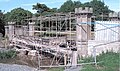
[[Image:Tournament Bridge 2008.jpg|thumb|The bridge partially dismantled and half way through hydrodemolition during renovation in May 2008.]] |
|||
[[Image:Dam at Tournament Bridge.JPG|left|thumb|<Center>The temporary earth dam in the Lugton Water.]] |
|||
The restoration of the Tournament Bridge involves a faithful and historic renovation of the Tournament Bridge, based on surviving documentary evidence. [[Historic Scotland]] requires a ‘faithful restoration where all details are replicated as closely as possible in terms of material, design and construction’. |
|||
[[Image:Turnament bridge repair.JPG|right|thumb|<Center>Close up of a repair to the cracked cast iron.]] |
|||
The existing concrete arches are to be removed as is the infill above. The arches will be replaced with the existing refurbished cast iron arch sections and new cast iron fascia sections, which will restore the original width of the structure. A secondary stainless steel pedestrian parapet is to be provided immediately behind the ballustrading. The load bearing capacity of the bridge will be carried by a modern steel structure concealed beneath the deck surface which will be timber, as this was considered to be the original material.<ref name=NACmins">[http://www.north-ayrshire.gov.uk/chiefexec/minutes.nsf/6939f82190c5aae2802572dd0046f16c/2e30178e790d6ec8802573f300400832?OpenDocument Minutes of North Ayrshire Council Executive Committee]</ref> |
|||
The current timber parapets will be replaced with cast iron sections to match the original items. All of the cast iron elements are to be fabricated and fitted by the Ballantine [[Bo'ness]] Iron Company to restore the splendour of the original structure.<ref name="Irvine Herald">The Irvine Herald, Friday 25th April, 2008. P. 10.</ref> |
|||
==Rail Sample Box== |
|||
The restoration involved [[hydrodemolition]] to expose the cast iron arches through removing the concrete in which they had been embeded. This process used very high pressure water jets and confirmed the poor structural integrity of the iron arches. They were not however intended to be load bearing in the restored bridge and an upside was the degree of Gothic artwork found to exist on the arches.<ref name="NAC2">North Ayrshire Council, Roads and Transportation services. 2008</ref> |
|||
{{rail start}} |
|||
{{rail line|previous=[[Seamer railway station|Seamer]]|next=Terminus|route=[[TransPennine Express]]<br><small>[[North TransPennine]]|col=}} |
|||
{{rail line|previous=[[Seamer railway station|Seamer]]|next=Terminus|route=[[Northern Rail]]<br><small>[[Yorkshire Coast Line]]|col=}} |
|||
{{rail line|previous=[[York railway station|York]]|next=Terminus|route=[[Midland Mainline]]<br><small>(Summer only)|col=}} |
|||
{{Disused Rail Insert}} |
|||
{{rail line|previous=Terminus|next=[[Scalby railway station|Scalby]]|route=[[Scarborough & Whitby Railway]]|col=}} |
|||
{{end box}} |
|||
The estimated total project cost is £720k. Historic Scotland have indicated that they would be able to contribute some £161k, around £5k will be provided in kind, and the shortfall of £354k was the subject of the successful grant application to the [[Heritage Lottery Fund]].<ref name="NAC">[http://www.north-ayrshire.gov.uk/ChiefExec/CommRA07.nsf/e9ee67f48fbb9003802569d700533758/1f6211e0e2530ce4802573e60045da0f?OpenDocument North Ayrshire Council minutes and the Tournament Bridge restoration]</ref> |
|||
===2008 restoration gallery=== |
|||
== Further Reading == |
|||
<gallery> |
|||
Image:DSCN5379.JPG|<Center>Work begins. |
|||
Image:DSCN3137.JPG|<Center>A hydrodemolition operative in protective clothing. |
|||
Image:DSCN3200.JPG|<Center>A cast iron cross strut holding the arches together so they do not move sideways. |
|||
Image:Eglinton Tournament Bridge cast iron beams.jpg|<Center>Detail of the cast iron arches. |
|||
Image:DSCN3202.JPG|<Center>Detail of the Gothic ornamentation on the cast iron arches. Note the cracks in the ironwork. |
|||
Image:DSCN3208.JPG|<Center>The concrete decking prior to hydrodemolition and the exposure of the cast iron arches. |
|||
Image:DSCN3158.JPG|<Center>The concrete removed and the cast iron arches exposed. |
|||
Image:DSCN3078.JPG|<Center>Brickwork exposed between the cast iron arches. |
|||
Image:DSCN3163.JPG|<Center>Fully exposed cast iron arches. |
|||
Image:Eglinton Tournament Bridge construction details of pier.jpg|<Center>Details of the central pier's construction. |
|||
Image:Eglinton Tournament Bridge scaffolding.jpg|<Center>Ready for painting. |
|||
Image:Central pier Tournament Bridge.JPG|<Center>The white protective paint and the central pier. |
|||
Image:Tournament Bridge cutwater repairs.JPG|<Center>Repairs underway to the central pier and cutwaters. |
|||
Image:Iron stone binding.JPG|<center>An old iron stone block binding. These expanded as they rusted and ironically led to the loosening of the stonework. |
|||
Image:Eglinton Masons.JPG|<center>At work on the stone for the central pier. Note the craft tools. |
|||
Image:Tournament Bridge Mason.JPG|<center>Marking out a block before cutting out the design. |
|||
</gallery> |
|||
== See also == |
|||
*{{cite book|author=R.V.J.Butt, |title= The Directory of Railway Stations |publisher=Patrick Stephens Ltd |year=1995}} ISBN 1 85260 508 1 |
|||
*[[The Iron Bridge]] - the world's first iron bridge |
|||
* {{cite book|author=J.H. Lucking , |title=Railways of Dorset |publisher=[[Railway Correspondence and Travel Society]] 1968 |year=}} ISBN(no ISBN) |
|||
* {{cite book|author=Brian L. Jackson |title=The Abbotsbury Branch |publisher=Wild Swan Publications Ltd. 1989 |year=}} ISBN 0 906867 80 0 |
|||
* {{cite book|author=John Scott - Morgan |title=British Independent Light Railways |publisher=David & Charles 1980 |year=}} ISBN 0-7153-7933-X |
|||
* {{cite book|author=[[Robert Adley]] , |title=Covering My Tracks |publisher=Patrick Stephens Ltd |year=1988}} ISBN 0-85059-882-6 |
|||
== References == |
|||
* {{cite book|author=Paul Karau , |title=Great Western Branch Line Termini Combined edition |publisher=Oxford Publishing Company and Paul Karau |year=1977}} ISBN 0-86093-369-5 |
|||
{{Reflist|2}} |
|||
{{commonscat|Footbridges}} |
|||
* {{cite book|author=Chris Leigh , |title=GWR Country Stations |publisher=Ian Allan Ltd |year=1981}} ISBN 0-7110- 1108-7 |
|||
[[Category:Bridges in Scotland]] |
|||
* {{cite book|author=Vic Mitchell and Keith Smith , |title=Branch Lines Around Wimborne |publisher=Middleton Press 1992 |year=}} ISBN 0 906520 97 5 |
|||
[[Category:Pedestrian bridges]] |
|||
[[Category:Gothic architecture|*]] |
|||
[[Category:History of North Ayrshire]] |
|||
==External References== |
|||
http://www.subbrit.org.uk/sb-sites/stations/k/knowle_halt/index.shtml |
|||
List of UK junctions with no station |
|||
http://www.semleystation.com/html/where.html |
|||
==External References== |
|||
==Dorset Stations with no articles== |
|||
:Combpyne |
|||
:Lyme Regis |
|||
==Somerset Stations with no articles== |
|||
Marston Magna |
|||
Sparkford |
|||
Limpley Stoke |
|||
==Bovington Camp Article Upgrade== |
|||
:Bovington Camp[http://www.tankmuseum.co.uk/home.html] |
|||
:Garrison Church[http://people.bath.ac.uk/lismd/dorset/churches/bovington.html] |
|||
:MoD since 1916[http://www.mod.uk/DefenceInternet/DefenceFor/ServiceCommunity/Hive/SouthWest/BovingtonHive.htm] |
|||
:[[Bovington Tank Museum]] |
|||
:[[Clouds Hill]] |
|||
:[[Lawrence of Arabia]] (Died on road to Clouds Hill) |
|||
:[[Royal Tank Regiment]] (Based There?) |
|||
:[[Junior Leaders' Regiment]] (Based there?) |
|||
:[[Monkey World]] (A mile away to the east) |
|||
:[[Prince William of Wales]] (Four months at camp during training) |
|||
:[[Tank]] |
|||
==Southampton Civic Centre Tunnel Article== |
|||
'''Southampton Civic Centre Tunnel,''' is a railway tunnel beneath the Civic Centre in the centre of the [[Hampshire]] city of [[Southampton]], in England. Opening in August of 1847, [http://web.ukonline.co.uk/cj.tolley/cjt-brhl.htm], its construction linked the stations of [[Southampton Terminus railway station|Southampton Terminus]] and Southampton West End (later moved and now known as [[Southampton Central railway station|Southampton Central]]) and made possible a link from London through Southampton to towns further west, such as [[Poole]] and [[Dorchester]]. The through link also speeded up the expansion of [[Bournemouth]]. |
|||
==Construction and operating problems== |
|||
Geological problems plagued the construction and delayed its opening. They continue to cause problems: between 1983 and 1985 the tunnel underwent extensive engineering works, and the line through it was worked as a single line for long periods, while remedial work was carried out. [http://johnlawontherails.fotopic.net/p24608893.html]. A narrow gauge railway was set up as part of these works. |
|||
==Services using the tunnel== |
|||
The tunnel is mostly used by trains on the [[South Western Main Line]], with trains from [[Portsmouth]] on the [[Wessex Main Line]] and the local line from Portsmouth to Southampton also passing through. The local train from Totton to Romsey also uses the tunnel. The longest journeys for passengers are made by the routes from Bournemouth to various points in the north of England and Scotland, usually grouped under the banner of [[Cross Country services]]. |
|||
There is also extensive use for freight, most of which is containers for [[Southampton Container Terminals]] which lie to the west of Southampton Central station and are extensive. |
|||
==The Future== |
|||
Recent debate has ensued over the width of the tunnel[http://www.publications.parliament.uk/pa/cm200506/cmhansrd/cm060524/text/60524w0028.htm] |
|||
in order to take larger containers to the container terminals it will have to be enlarged and this may result in the closure of the line through the tunnel for an extensive period. |
|||
==Film== |
|||
Footage at the start of the film [[Oh, Mr Porter!]] features the tunnel at Southampton, filmed from the rear of the train and reversed for showing. [http://www.britmovie.co.uk/forums/location-location-location/2502-railway-station-oh-mr-porter.html] |
|||
==Solent Lines Diagram Idea== |
|||
{| {{Railway line header}} |
|||
{{BS-header|Solent Lines|#eeffff}} |
|||
{{BS-table}} |
|||
{{BS5||LUECKE|||||[[South Western Main Line]]|}} |
|||
{{BS5||BHF|||||[[Southampton Central railway station|Southampton Central]]}} |
|||
{{BS5||TUNNEL1|||||[[Southampton Civic Centre Tunnel]]}} |
|||
{{BS5||STR|||||}} |
|||
{{BS5|STRrg|ABZrf|||||}} |
|||
{{BS5|CPICl|CPICr|||||[[St Denys railway station|St Denys]]}} |
|||
{{BS5|STR|STR|||||}} |
|||
{{BS5|STR|HST|||||[[Swaythling railway station|Swaythling]]}} |
|||
{{BS5|STR|STR|||||}} |
|||
{{BS5|WBRÜCKE|STR|||||[[River Itchen]]}} |
|||
{{BS5|STR|STR|||||}} |
|||
{{BS5|STR|BHF||FLUG|||[[Southampton Airport Parkway railway station|Southampton Airport Parkway]]}} |
|||
{{BS5|STR|STR|||||}} |
|||
{{BS5|HST|STR|||||[[Bitterne railway station|Bitterne]]}} |
|||
{{BS5|HST|STR|||||[[Woolston railway station|Woolston]]}} |
|||
{{BS5|STR|STR|||||}} |
|||
{{BS5|STR|ABZfg|HBHF|HLUECKE|||[[Eastleigh railway station|Eastleigh]]|[[South Western Main Line]]}} |
|||
{{BS5|STR|ABZrg|xKDSl|HLUECKE|||[[Eastleigh Works]]}} |
|||
{{BS5|STR|STRlf|STRlg||||}} |
|||
{{BS5|STR||HST||||[[Hedge End]]}} |
|||
{{BS5|HST||STR||||[[Sholing railway station|Sholing]]}} |
|||
{{BS5|STR||eABZrg|exHLUECKE|||[[Bishops' Waltham railway station|Bishops' Waltham line]]}} |
|||
{{BS5|HST||STR||||[[Netley railway station|Netley]]}} |
|||
{{BS5|STR||HST||||[[Botley railway station|Botley]]}} |
|||
{{BS5|HST||STR||||[[Hamble railway station|Hamble]]}} |
|||
{{BS5|HST||STR||||[[Bursledon railway station|Busledon]]}} |
|||
{{BS5|HST||STR||||[[Swanwick railway station|Swanwick]]}} |
|||
{{BS5|STR||STR||||}} |
|||
{{BS5|STR||eABZrg|exHLUECKE|||[[Meon Valley Line|Former Meon Valley Line]]}} |
|||
{{BS5|STR||eHST||||[[Knowle Hospital railway station|Knowle Hospital Halt]]}}{{BS5|STR|exSTRrg|eABZrf||||Former Loop Line}} |
|||
{{BS5|STRlf|eABZ3lf|ABZlg||||}} |
|||
{{BS5|||BHF||||[[Fareham railway station|Fareham]]}} |
|||
{{BS5|exSTRrg|exHSTR|eABZrf||||}} |
|||
{{BS5|exHST||STR||||[[Fort Brockhurst railway station|Fort Brockhurst]]}} |
|||
{{BS5|exABZrf||STR||||''[[Lee on the Solent Light Railway]]''}} |
|||
{{BS5|exABZrd||STR||||''[[Stokes Bay Branch]]''}} |
|||
{{BS5|exBHF||STR||||[[Gosport railway station|Gosport]]}} |
|||
{{BS5|exKDSe||STR||||[[Clarence Yard]]}} |
|||
{{BS5|BOOT||STR||||[[Ferries]] to [[Isle of Wight]]}} |
|||
{{BS5|KBFa||STR|||45m 36ch|[[Portsmouth Harbour railway station|Portsmouth Harbour]]}} |
|||
{{BS5|BHF||STR|||44m 47ch|[[Portsmouth and Southsea railway station|Portsmouth & Southsea]]}} |
|||
{{BS5|eABZrg||STR||||[[North Dockyard line]]}} |
|||
{{BS5|STR||HST||||[[Portchester railway station|Portchester]]}} |
|||
{{BS5|eABZlg||STR||||[[East Southsea line]]}} |
|||
{{BS5|BHF||STR|||43m 64ch|[[Fratton railway station|Fratton]]}} |
|||
{{BS5|STR||HST||||[[Cosham railway station|Cosham]]}} |
|||
{{BS5|HST||STR|||41m 41ch|[[Hilsea railway station|Hilsea Halt]]}} |
|||
{{BS5|STR|STRrg|ABZrf|||41m 04ch||Cosham Jn}} |
|||
{{BS5|STRlf|ABZgf|STR|||41m 03ch||Portcreek Jn}} |
|||
{{BS5||eHST|STR||||[[Farlington railway station|Farlington]]}} |
|||
{{BS5||STRlf|ABZlg|||40m 38ch|Farlington Jn }} |
|||
{{BS5|||LUECKE|||38m 14ch|''[[West Coastway Line|West Coastway Line to Brighton]]''}} |
|||
|} |
|||
|} |
|||
==William Clarke (United Kingdom railway contractor) Article== |
|||
Station buildings for |
|||
Presteigne Branch |
|||
Kingsbridge Branch |
|||
Abbotsbury Branch |
|||
Limpley Stoke - Camerton |
|||
Stations |
|||
West Bay (Dorset) |
|||
Fencote (Hersfordshire) |
|||
== Further Reading == |
|||
* {{cite book|author=J.H. Lucking , |title=Railways of Dorset |publisher=[[Railway Correspondence and Travel Society]] 1968 |year=}} ISBN(no ISBN) |
|||
* {{cite book|author=Brian L. Jackson |title=The Abbotsbury Branch |publisher=Wild Swan Publications Ltd. 1989 |year=}} ISBN 0 906867 80 0 |
|||
* {{cite book|author=John Scott - Morgan |title=British Independent Light Railways |publisher=David & Charles 1980 |year=}} ISBN 0-7153-7933-X |
|||
* {{cite book|author=Paul Karau , |title=Great Western Branch Line Termini Combined edition |publisher=Oxford Publishing Company and Paul Karau |year=1977}} ISBN 0-86093-369-5 |
|||
* {{cite book|author=Chris Leigh , |title=GWR Country Stations |publisher=Ian Allan Ltd |year=1981}} ISBN 0-7110- 1108-7 |
|||
British Railway Journal No. 8 Summer 1985 |
|||
==References== |
|||
Rebuilding Clutton (A William Clarke station)[http://clutton.fotopic.net/]. |
|||
Rowden Mill (Clarke Station)[http://clutton.fotopic.net/c1034407.html] |
|||
Revision as of 18:37, 3 September 2008
Eglinton Tournament Bridge | |
|---|---|
 Tournament Bridge and castle in 1876[1] | |
| Coordinates | 55°38′41″N 4°40′12″W / 55.6446°N 4.6699°W |
| Carries | Pedestrians |
| Crosses | Lugton Water |
| Locale | Eglinton Country Park |
| Official name | Tournament Bridge |
| Maintained by | North Ayrshire Council Historic Scotland |
| Characteristics | |
| Design | Gothic |
| History | |
| Opened | c. 1845 |
| Location | |
 | |
The Eglinton Tournament Bridge is a bridge located within Eglinton Country Park near Kilwinning, North Ayrshire, Scotland. The bridge crosses the Lugton Water a short distance northwest of Eglinton Castle (OS ref: NS32064224) and was named after the Eglinton Tournament of 1839. The castle and surrounding grounds were once home to the Montgomerie family, Earls of Eglinton and chiefs of the Clan Montgomery.
History
The Tournament Bridges
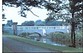
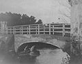
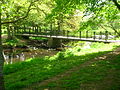
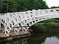
The surviving Tournament Bridge was built to provide an appropriate crossing point to gain access to the far side of the Lugton Water. Archibald Montgomerie, the 13th Earl of Eglinton had the bridge built in a Gothic style, using cast iron for the arches, pinnacles, etc. and stone for the two pairs of miniature ornamental towers at either end. These towers have subtle design differences (See photographs) which are significant in the context of the extended history of the bridge. This 'Tournament' bridge was designed by the architect David Hamilton. The bridge's cast iron parapet is a repetition of the pointed Gothic arch design of the castle, surmounted by a battlement, and relieved in the centre with foliated pinnacles.[2] The Tournament Bridge is B listed by Historic Scotland.[3]


The 1839 Eglinton Tournament was held on a meadow or holm at a loop in the Lugton Water. Most of the holm no longer exists, the excavations in this area having provided gravel and sand for the construction of the Kilwinning bypass and leaving behind an excavation pit which is now known as Eglinton Loch. The Knights on horseback and their retinue reached the tilt yard ('C' on the map) via an enclosed ride ('G' on the map), whilst the guests and visitors made their way to the stands via the route marked 'F' on the map illustrated. Both groups crossed over the previous three arched Gothic bridge. A map of 1837 of Eglinton Castle, Grounds and Tilt yard of 1837 shows that the tilt yard was already in extistence at this early date, but it is not recorded what its fate was after the tournament was over.[7]

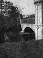
The 'new' Tournament Bridge served as a well used route across the Lugton Water, running through the deer park to the Eglinton kennels (previously Laigh Moncur), especially on days when the Eglinton Hunt met at the castle itself.

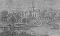
The original bridge, also with two miniature towers, but with three arches and four pinnacles, stood roughly 100 yards further up the river towards the castle,[8] as shown in several contemporary prints and maps as illustrated in the appropriate gallery of this article.[9] It was this bridge that was used at the Eglinton Tournament as can be seen from the illustrations of the event, however the name was passed on to the 'new' bridge constructed downstream of it. No clear sign of this three arched bridge remains, a weir having been built at its old position; the 'old' bridge was constructed in 1811[10][11], therefore around the time of the 'new' castle being built in 1801/2 and also when the grounds were being laid out by Tweedie.
Surviving architects drawings show the designs for a three arched bridge and as stated, contemporary prints of the Eglinton Tournament also show a three arched Tournament bridge, with cast iron arches, pinnacles and parapets which may have been re-used in the later 'new' bridge which survives today.
The point at which the 'old' bridge crossed the Lugton was 102 feet broad and 100 yards downriver from the castle.[12] It had the Montgomerie coat of arms in the centre. Aiton describes it as being under construction in 1811.[13] The miniature castle towers on the demolished bridge are shown as each being surmounted by a double cross, but these do not figure on the 'new' Tournament Bridge; the 'old' bridge therefore may have been specially embellished for the tournament with temporary additions.


A local minister, the Rev. Lee Ker, confirms which bridge was used at the tournament by relating in his book on Kilwinning that the tournament procession passed over the Water of Lugton by what is now called the Tournament Bridge, but which was then situated about 100 yards nearer the Castle and had three arches instead of two.[16] This distance coincides with a weir today and an old path from the castle leads directly to it. Dane Love states that the bridge used by the tournament had been built by the 12th Earl in 1811.[17] In contemporary reports of the tournament no special mention of the bridge is made, suggesting that it was already a well established feature of the estate by that time and not an extravagant new feature specially built for the event.
Lauchlan[18] confuses the issue by stating that an older bridge with three arches existed 100 yards up from the present one, however he states that the present bridge was built for the tournament. The old three arched bridge in fact still existed in 1840[19] and at least as late as 1843.[20]
Construction of the 'new' Tournament Bridge
The new bridge may have been erected by the 13th Earl at some time between 1843 and 1856 as part of the total re-modelling of the course of the Lugton Water which had been first undertaken by the 12th Earl (1740 - 1819)[21] and which included the alteration of its course, the removal of the lakes or ponds and the creation of several weirs. The Lugton Water is liable to severe floods[22] and damage to the easily broken cast iron work by the force of the current, may have been a reason for its reconstruction at a different site. The first Ordnance Survey map of 1856 shows the two arched bridge in position, a weir at the position of the old bridge and by this time the old lake had gone, replaced by a canalised Lugton Water with several weirs.

Ironically the strengthening work done on the 'new' bridge to produce an extra arch of bricks in addition to the cast iron, may have weakened the structure, contributing to its eventual partial collapse.[23] The army used the bridge extensively with large lorries and even tanks crossong over it.
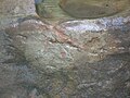
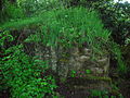
The lower courses of ashlar[24] on the bridge abutments and central pier were vermiculate.[25] At some point the height of the weir beneath had been raised using an odd assortment of re-used stonework; this would have increased the depth and extent of the waters behind it. The central pier and the original weir had used reworked but re-cycled stone, probably from Kilwinning Abbey; as illustrated by a stone window surround recovered during restoration work (See illustration).
Examination of the top of the outer towers shows that something was attached to the centres, the 'plug' hole still being present. It is possible that the holes are relate dto the method of lifting them into position during construction work. The larger towers are capped with cement and nothing is therefore visible. During restoration work (2008) electricity power cables or possibly gas pipes were located leading to the bridge and they may have served lights on top of some or all of the towers.[26] These are not visible in the available illustrations. The Eglinton estate had its own gasworks and later its own power station, so it would have been natural to provide lighting on the bridge. The old OS maps show that by 1897 the gas works had been established here to supply the castle and offices, whilst by 1911 this had been replaced by an electricity works; the present day park workshop.

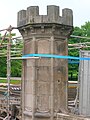
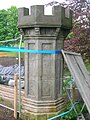
The larger and taller inner towers appear to have been re-used from the older bridge, this being confirmed by the presence of ornate carving which is now obscured by the low wall leading to them from the smaller towers. The curtain walls and the smaller and lower outer towers are made from a different type of stone and, as stated, the towers have a number of architectural differences, suggesting that they were made specifically for the 'new' Tournament Bridge (See photographs). During work on the central pier it was found that some of the hidden infill work is vermiculate ashlar from the 'old' bridge.
The cast iron sections of the arches are numbered and some of the sequence are absent, suggesting that these missing sections may have been damaged previously beyond repair and were not used therefore in the 'new' bridge.
Older bridges gallery
-
A view of the castle and a wooden footbridge in 1815. -
Details of the wooden bridge. -
The castle and bridge in 1815. Three arches and a lake are depicted. -
![Eglinton Castle & Bridge. This again shows the original three arched bridge, lake, etc. Circa 1843.[27]](//upload.wikimedia.org/wikipedia/commons/thumb/0/08/Eglinton_tournament_bridge_in_1843.jpg/120px-Eglinton_tournament_bridge_in_1843.jpg)
Eglinton Castle & Bridge. This again shows the original three arched bridge, lake, etc. Circa 1843.[27]


![Eglinton Castle & Bridge. This again shows the original three arched bridge, lake, etc. Circa 1843.[27]](/wiki/File:Eglinton_tournament_bridge_in_1843.jpg)
The 'new' Tournament Bridge
-
The Tournament bridge as restored in the 1980s. -
Flood conditions. -
The Tournament Bridge over the Lugton Water in 2007. -
The approach to the Tournament Bridge from the stables in 2007. -
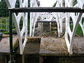
A benchmark on one of the bridge towers. -
One of the large bridge towers, probably recycled from the 1811 bridge. -
One of the smaller towers with subtle design and carving differences suggesting a later date of construction. -
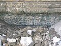
Vermiculate ashlar stonework on the abutment of the bridge at water level. -

A reworked stone window ledge, possibly from Kilwinning Abbey, used in the weir at the central pier. -

Details of how one of the recycled towers has been incoroprated into the new design. -
Hydrodemolition damage to the central pier. -

Recycled stones built into the weir beneath the bridge. One has the remains of two corbels and may well have come from the pre-1802 medieval castle. -
A Mason's Mark on the corbelled stone. -

A cut water, possibly from the 'new bridge,' but removed during the 'army works.' -

A section of an 'old' bridge tower used in the weir. -

The weir made from sections of the old large 'towers.'


The Tournament Bridge and WWII
The Eglinton Castle Estate was requisitioned during World War II and during this occupation the Tournament Bridge partly collapsed, partly due to alterations which had been made earlier by the Eglinton Estate, involving supposed strengthening using brickwork, as revealed during the 2008 restoration work.[28] The bridge was never designed to take the heavy army lorries and tanks which used the bridge during the army occupation of the site and this led to a partial collapse in the 1940s. To save the bridge from total collapse the army Royal Engineers Regiment removed the cast iron outer facia coverings and the pinnacles, encasing the remaining cast iron arches in concrete as can be seen from contemporary photographs and as further revealed during restoration work. It is not known what happened to the pinnacles and cast iron coverings. It had been thought that they were safely in storage, however enquiries have led to nothing.[28]
Repair work
-
 A view showing the partial collapse of the bridge.
 -
 Repair work underway, showing the shuttering for the concrete.
 -
 The repaired bridge. Note the simple wooden handrail and the remaining exposed iron arch.
 -
 A view of the whole of the repaired bridge. Note the army personnel and lots of children fishing, etc.


Other estate bridges


Originally the river would have been crossed by simple fords, however by the 18th century ornamental pleasure gardens had been formed and these were partly situated in what later became the deer park. No signs of these gardens are now visible, apart from Crop marks on aerial photographs taken around the end of the Second World War. A bridge was necessary to give access to the ornamental gardens and one is indicated on John Ainslie's map dated 1790, crossing the Lugton Water close to the castle itself. A small wooden bridge across the Lugton Water is shown in an illustration from around 1815, however this may not have been across the Lugton Water. Thomson's map of 1828 (See illustration) indicates a bridge crossing the Lugton Water at the castle where the three arched bridge was and a drive starting off at the position of the present day bridge, which may have been a ford at the time. Another bridge is suggested further upstream and close to the castle.[29] The wooden Laundry Bridge stood close to the castle and downstream from it was second wooden bridge which was washed away in a storm in 1938. Local children used it to build rafts.


The restored Stables Bridge, also called Lady Jane's Bridge, lies on the Kilwinning Lodge drive and just downstream from it stood an elegant cast-iron bridge with a 50 foot span.[12] This bridge had high quality stonework on both of the abutments, much of which survive. This bridge gave access to the kitchen walled gardens and glasshouse ranges and lasted into the mid 1940s when the army removed it.
The Suspension Bridge built by the army in the 1980s on behalf of the country park lies just below the weir beside the ruined gazebo. Lady Jane's cottage had a wooded pedestrian footbridge of which no sign remains.
The restored Diamond Bridge lies upstream near the Eglinton Loch and continues to give access to the old Toll Road from Irvine to Kilwinning via Fergushill. This bridge was named after the nearby Black Diamond mine, the spoil heap or bing of which still remains rear the Chapelholm Gate. The colliery name in turn was associated with one of the 13th Earl's favourite horses, Black Diamond.
A Gallery of the other bridges
-
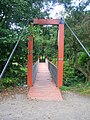
The suspension bridge over the Lugton Water. -

The suspension bridge and cascade weir. -

Lady Jane's cottage with its footbridge across the Lugton Water. -

The Diamond Bridge undergoing restoration. -

The Chapelholm or 'Diamond' bridge. -
The Stable's Bridge. -
An abutment of the old Walled Garden bridge. Iron work is embedded in the structure, which was faced with high quality vermiculate ashlar stonework. -
![A vermiculate[25] stone from the ornate Walled Garden bridge.](//upload.wikimedia.org/wikipedia/commons/thumb/a/ac/Stucco_stone_from_footbridge.JPG/120px-Stucco_stone_from_footbridge.JPG)
A vermiculate[25] stone from the ornate Walled Garden bridge. -
The original Laundry Bridge in the 1900s. -
The 'new' castle or Laundry footbridge. -

The view across the Laundry or Castle Bridge.


![A vermiculate[25] stone from the ornate Walled Garden bridge.](/wiki/File:Stucco_stone_from_footbridge.JPG)


Lugton Water


The Lugton Water was diverted and altered several times, for example in the 1790s its course was altered by the 12th Earl (1740 - 1819)[31] to run behind the Garden Cottage, rather than in front of it. The width was also changed at times, for instance five ponds or lakes were created by large weirs at one stage; the one at the Tournament Bridge is clearly visible in older prints of the 1840s (see illustrations) shown.[32]
The size, shape and position of the various weirs was altered several times, latterly by Clement Wilson of the canning factory. One of the weirs lies directly beneath the restored Tournament Bridge. The one below the site of the old Bowling Green and Robert Burns's garden was 'U' shaped, holding back sufficient water at one time to form a lake with a small island bearing a single yew tree. The 1938 OS map shows no fewer than seven weirs between the castle and the present day Suspension Bridge.
The Clement Wilson gardens

In 1948 the Trustees of the late 16th Earl sold most of the remaining parts of the estate to Robert Howie and Sons of Dunlop for £24,000[33][34] and in the 1950s the Wilson family purchased the Tournament Bridge, old offices, castle ruins, and other land from Robert Howie and Sons.
Clement Wilson, the food processing factory owner, established the Clement Wilson Foundation which opened part of the grounds to the public, spending around £400,000 (around £4,317,000 in 2008 terms) on partially restoring the Tournament Bridge, consolidating the castle ruins, planting trees, landscaping, making paths, creating a rockery and waterfall feature, etc.[35]
2008 restoration


The restoration of the Tournament Bridge involves a faithful and historic renovation of the Tournament Bridge, based on surviving documentary evidence. Historic Scotland requires a ‘faithful restoration where all details are replicated as closely as possible in terms of material, design and construction’.

The existing concrete arches are to be removed as is the infill above. The arches will be replaced with the existing refurbished cast iron arch sections and new cast iron fascia sections, which will restore the original width of the structure. A secondary stainless steel pedestrian parapet is to be provided immediately behind the ballustrading. The load bearing capacity of the bridge will be carried by a modern steel structure concealed beneath the deck surface which will be timber, as this was considered to be the original material.[36]
The current timber parapets will be replaced with cast iron sections to match the original items. All of the cast iron elements are to be fabricated and fitted by the Ballantine Bo'ness Iron Company to restore the splendour of the original structure.[37]
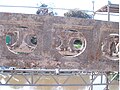
The restoration involved hydrodemolition to expose the cast iron arches through removing the concrete in which they had been embeded. This process used very high pressure water jets and confirmed the poor structural integrity of the iron arches. They were not however intended to be load bearing in the restored bridge and an upside was the degree of Gothic artwork found to exist on the arches.[28]
The estimated total project cost is £720k. Historic Scotland have indicated that they would be able to contribute some £161k, around £5k will be provided in kind, and the shortfall of £354k was the subject of the successful grant application to the Heritage Lottery Fund.[38]
2008 restoration gallery
-
Work begins. -
A hydrodemolition operative in protective clothing. -
A cast iron cross strut holding the arches together so they do not move sideways. -
Detail of the cast iron arches. -
Detail of the Gothic ornamentation on the cast iron arches. Note the cracks in the ironwork. -
The concrete decking prior to hydrodemolition and the exposure of the cast iron arches. -
The concrete removed and the cast iron arches exposed. -
Brickwork exposed between the cast iron arches. -
Fully exposed cast iron arches. -

Details of the central pier's construction. -
Ready for painting. -
The white protective paint and the central pier. -

Repairs underway to the central pier and cutwaters. -

An old iron stone block binding. These expanded as they rusted and ironically led to the loosening of the stonework. -

At work on the stone for the central pier. Note the craft tools. -
Marking out a block before cutting out the design.


See also
- The Iron Bridge - the world's first iron bridge
References
- ^ Dobie, James (1876). Pont's Cuninghame Pub. John Tweed.
- ^ Millar, A. H. (1885). The Castles and Mansions of Ayrshire.' Reprinted by The Grimsay Press (2004). ISBN 1-84530-019x. P. 74.
- ^ Historic gardens
- ^ Aikman, James (1839). An account of the tournament at Eglinton, revised and corrected by several of the knights : with a biographical notice of the Eglinton family to which is prefixed a sketch of chivalry and of the most remarkable Scottish tournaments. Pub. Edinburgh : H. Paton, Carver and Gilder. Facing P. 4.
- ^ Tait's Edinburgh Magazine. November 1839.
- ^ Stoddart, John (1801). Remarks on Local Scenery and Manners in Scotland during the years 1799 and 1800. Pub. William Miller, London. P. 313.
- ^ Anstruther, Ian (1986). The Knight and the Umbrella. An Account of the Eglinton Tournament 1839. Pub. Alan Sutton. Gloucester. ISBN 0-86299-302-4. P. III.
- ^ Ness, J. A. (1969 - 70). Landmarks of Kilwynnyng. Privately produced. P. 29.
- ^ Aitken, Robert (1829). The Parish Atlas of Ayrshire - Cunninghame. Pub. W. Ballantine. Edinburgh.
- ^ Close, Rob (1992), Ayrshire Buildings. Royal Incorporated Architects of Scotland. ISBN 1873-190-069. P. 64.
- ^ Ayrshire Roots
- ^ a b Aiton, William (1811). Extract from the General View of the Agriculture of Ayr.
- ^ Aiton, William (1811). Extract from the General View of the Agriculture of Ayr.
- ^ North Ayrshire Council, Roads and Transportation services. 2008
- ^ The Eglinton Tournament. Pub. Hodgson & Graves. London. 1840. P. 6.
- ^ Ker, Rev William Lee (1900). Kilwinning Pub. A. W. Cross, Kilwinning. P. 326.
- ^ Love, Dane (2003). Ayrshire: Discovering a County. Pub. Fort. Ayr. ISBN 0-9544461-1-9. P. 54.
- ^ Lauchlan, Roy (1989). Questions & Answers about the Montgomerie Family and the 1839 Tournaments. Pub. Kilwinning & District Preservation Society. P. 12.
- ^ Leighton, John M. (1850).Strath Clutha or the Beauties of the Clyde. Pub. Joseph Swan Engraver. Glasgow. Facing P. 229.
- ^ The Ayrshire Wreath MDCCCXLIII (1843): a collection of original pieces, in prose and verse, chiefly by native authors, on subjects relating to Ayrshire. Pub. H. Crawford & Son. Kilmarnock. Facing Title page.
- ^ Landscape of the Knights. The Eglinton Story. Rub. Irvine Development Corporation. 1992. P. 27.
- ^ The Eglinton Archive.
- ^ North Ayrshire Council, Roads and Transportation services. 2008
- ^ - Ashlar
- ^ a b - Vermiculate stonework Cite error: The named reference "Vermiculate" was defined multiple times with different content (see the help page).
- ^ North Ayrshire Council, Roads and Transportation services. 2008
- ^ The Ayrshire Wreath MDCCCXLIII (1843):a collection of original pieces, in prose and verse, chiefly by native authors, on subjects relating to Ayrshire. Pub. H. Crawford & son. Kilmarnock. Facing Title page
- ^ a b c North Ayrshire Council, Roads and Transportation services. 2008
- ^ a b Thomson, John (1828). A Map of the Northern Part of Ayrshire.
- ^ Roy, William (1747 - 55) Military Map of Scotland.
- ^ Landscape of the Knights. The Eglinton Story. Rub. Irvine Development Corporation. 1992. P. 27.
- ^ Montgomeries of Eglinton. Ayr Division. Strathclyde Department of Education. P. 94.
- ^ Landscape of the Knights. The Eglinton Story. Rub. Irvine Development Corporation. 1992. P. 12.
- ^ Sharp, Cameron (2007). Eglinton Country Park Management Plan for 2007 - 2011. North Ayrshire Council. P. 5.
- ^ Wilson, James (2008). Eglinton Archives - Written correspondence.
- ^ Minutes of North Ayrshire Council Executive Committee
- ^ The Irvine Herald, Friday 25th April, 2008. P. 10.
- ^ North Ayrshire Council minutes and the Tournament Bridge restoration