
Hermitage High School (Virginia) and Eglinton Tournament Bridge: Difference between pages
No edit summary |
Rosser1954 (talk | contribs) |
||
| Line 1: | Line 1: | ||
{{Infobox |
{{Infobox Bridge |
||
|bridge_name = Eglinton Tournament Bridge |
|||
|name= <span style="color:#0000FF;">Hermitage High School</span> |
|||
|image = Eglintoncastle1876.jpg |
|||
<!-- Commented out because image was deleted: |image= Panther2.gif --> |
|||
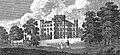
|caption = Tournament Bridge and castle in 1876<ref name="Dobie">Dobie, James (1876). ''Pont's Cuninghame'' Pub. John Tweed.</ref> |
|||
|imagesize= 100px |
|||
|official_name = Tournament Bridge |
|||
|motto= |
|||
|carries = Pedestrians |
|||
|motto_translation= |
|||
|crosses = [[Lugton Water]] |
|||
|streetaddress= 8301 Hungary Spring Road |
|||
| |
|locale = [[Eglinton Country Park]] |
||
| |
|maint = [[North Ayrshire Council]]<br>[[Historic Scotland]] |
||
| |
|id = |
||
|design = Gothic |
|||
|url= [http://www.henrico.k12.va.us/hs/hermitage Official Site] |
|||
|mainspan = |
|||
|district= [[Henrico County Public Schools]] |
|||
|length = |
|||
|superintendent= Frederick S. Morton IV |
|||
| |
|width = |
||
|height = |
|||
|viceprincipal= Diane Saunders<br>Cheryl Montgomery<br>Naeemah Rodriguez<br>Brock Goehler<br>Dan Dunham |
|||
|load = |
|||
|viceprincipal_label=Assistant Principals |
|||
|clearance = |
|||
|schooltype= Public [[High school#United States|high school]] |
|||
| |
|below = |
||
|traffic = |
|||
|language= [[American English|English]] |
|||
| |
|begin = |
||
| |
|complete = |
||
| |
|open = c. 1845 |
||
| |
|closed = |
||
| |
|toll = |
||
|map_cue = |
|||
|enrollment_as_of= 2006-2007 |
|||
|map_image = |
|||
|free_label_1= Rival Schools |
|||
|map_text = |
|||
|free_1= [[Deep Run High School]], [[Godwin High School]], [[John Randolph Tucker High School]] |
|||
| |
|map_width = |
||
|coordinates = {{coord|55.6446|-4.6699|type:landmark_region:GB|display=inline,title}} |
|||
|free_2= |
|||
|free_label_3= Athletic Conference |
|||
|free_3= [[Virginia High School League]]<br>[[AAA Central Region]]<br>[[AAA Colonial District]] |
|||
|box_width= 25em |
|||
|bgcolor_section= #FF0000 |
|||
|bgcolor_label= #efefef |
|||
|bgcolor_value= #efefef |
|||
|bgcolor_image= #efefef |
|||
|bgcolor_address= #efefef |
|||
|bgcolor_url= #efefef |
|||
}} |
}} |
||
The '''Eglinton Tournament Bridge''' is a [[bridge]] located within [[Eglinton Country Park]] near [[Kilwinning]], [[North Ayrshire]], [[Scotland]]. The bridge crosses the [[Lugton Water]] a short distance northwest of [[Eglinton Castle]] (OS ref: {{oscoor|NS32064224|NS32064224}}) and was named after the [[Eglinton Tournament of 1839]]. The castle and surrounding grounds were once home to the Montgomerie family, [[Earl of Eglinton|Earls of Eglinton]] and chiefs of the [[Clan Montgomery]]. |
|||
== History == |
|||
Hermitage High School is located in [[Henrico County, Virginia]]. Hermitage is a [[Blue Ribbon School]] for excellence in [[Music]] and [[Art Education]] (only 300 out of 133,000 schools are selected as Blue Ribbon each year). Hermitage also offers a driver education course, 20th century history class, and a [[MCJROTC]] unit. In addition, Hermitage is home to the [http://www.henrico.k12.va.us/HS/HermitageTech/ Hermitage Tech Center] that offers a number of field specific classes, and also home to the Hermitage Humanities Center. |
|||
{{See also|Eglinton Castle}} |
|||
====The Tournament Bridges==== |
|||
== Athletics and music== |
|||
The surviving Tournament Bridge was built to provide an appropriate crossing point to gain access to the far side of the [[Lugton Water]]. [[Archibald Montgomerie, 13th Earl of Eglinton|Archibald Montgomerie]], the 13th [[Earl of Eglinton]] had the bridge built in a [[Gothic architecture|Gothic]] style, using cast iron for the arches, pinnacles, etc. and stone for the two pairs of miniature ornamental towers at either end. These towers have subtle design differences (See photographs) which are significant in the context of the extended history of the bridge. This 'Tournament' bridge was designed by the architect [[David Hamilton (architect)|David Hamilton]]. The bridge's cast iron [[parapet]] is a repetition of the pointed Gothic arch design of the castle, surmounted by a battlement, and relieved in the centre with foliated [[pinnacle]]s.<ref name="Millar">Millar, A. H. (1885). ''The Castles and Mansions of Ayrshire.' Reprinted by The Grimsay Press (2004). ISBN 1-84530-019x. P. 74.</ref> The Tournament Bridge is B listed by [[Historic Scotland]].<ref name="Historic">[http://www.historic-scotland.gov.uk/gardens_search_more_info.htm?s=eglinton+castle&r=Glasgow%2c+Clyde+and+Ayrshire&bool=1&PageID=2374&more_info=Site Historic gardens]</ref> |
|||
Hermitage is home to many athletic teams/sports including baseball,cross country, wrestling, indoor and outdoor track teams, soccer, field hockey, volleyball, soft ball, competition cheerleading squad, basketball, football, dance team, a step team, and a tennis team. Hermitage often has one of the best football teams in the central region.The Panthers also achieved a Regional championship by defeating highland springs and meadowbrook in the central region playoffs in 2007. In addition to its highly rated football team, its band is the best known in the state of Virginia. The Marching Panthers recently performed for British Queen Elizabeth II, during her visit to the Capitol in Richmond as part of her commemoration of the 400th anniversary of Jamestown's founding. |
|||
[[Image:Eglinton Tournament Bridge and procession in 1839.jpg|left|thumb|<Center>The original Tournament Bridge and the procession in 1839. Note the three cast iron arches, crossed finials, pinnacles, and the taller, broader towers, etc. characteristic of that bridge.<ref name="Aikman">Aikman, James (1839). ''An account of the tournament at Eglinton, revised and corrected by several of the knights : with a biographical notice of the Eglinton family to which is prefixed a sketch of chivalry and of the most remarkable Scottish tournaments.'' Pub. Edinburgh : H. Paton, Carver and Gilder. Facing P. 4.</ref>]] |
|||
The 2007 central Regional champions offense was led by: QB/SS JUJU clayton Sr., WR Dominique Booker Sr., Jamel Davis Sr., RB Justin White Sr., TE/WR/DT Duan Perez Means Jr., WR/QB/SS Theron Norman Jr. |
|||
[[Image:A map of the Eglinton Tournament features.jpg|right|thumb|<Center>A map showing the layout of the various features associated with the Eglinton Tournament. Note the lakes either side of the bridge<ref name="Tait">Tait's Edinburgh Magazine. November 1839.</ref>, formed around 1800.<ref name="Stoddart">Stoddart, John (1801). ''Remarks on Local Scenery and Manners in Scotland during the years 1799 and 1800.'' Pub. William Miller, London. P. 313.</ref>]] |
|||
The 2007 Central Regional Champions defense was led by: C Gus Espionsaza Sr., DL/OL Abu Kamara Jr., QB/SS Juju Clayton Sr., WR/SS Theron Norman Jr., DB Justin Carr Sr., |
|||
The [[1839]] Eglinton Tournament was held on a meadow or holm at a loop in the Lugton Water. Most of the holm no longer exists, the excavations in this area having provided gravel and sand for the construction of the Kilwinning bypass and leaving behind an excavation pit which is now known as Eglinton Loch. The Knights on horseback and their retinue reached the [[Tiltyard|tilt yard]] ('C' on the map) via an enclosed ride ('G' on the map), whilst the guests and visitors made their way to the stands via the route marked 'F' on the map illustrated. Both groups crossed over the previous three arched Gothic bridge. A map of 1837 of ''Eglinton Castle, Grounds and Tilt yard'' of 1837 shows that the tilt yard was already in extistence at this early date, but it is not recorded what its fate was after the tournament was over.<ref name="Anstruther">Anstruther, Ian (1986). ''The Knight and the Umbrella. An Account of the Eglinton Tournament 1839''. Pub. Alan Sutton. Gloucester. ISBN 0-86299-302-4. P. III.</ref> |
|||
JuJu Clayton Recieed ALL-State offensive Player of the year, all-region player of the year, and All district player of the year. congratulations JUJU, good luck in college and the Pros. |
|||
[[Image:Eglinton Castle & Tournament Bridge 1884.jpg|thumb|left|<center>The castle and Tournament Bridge in 1884.]] |
|||
In 1992-1993, Matt Kellam, left offensive guard and middle linebacker, led the Panther's football team to a 5-5 record. His 5'7" 189 pound frame was an imposing site to opposing teams. Matt will also be remembered for his spirit and colorful humor. He was sorely missed from the Panther football program for the next 8 years as Hermitage struggled to post a record above .500. |
|||
The 'new' Tournament Bridge served as a well used route across the Lugton Water, running through the deer park to the Eglinton kennels (previously Laigh Moncur), especially on days when the Eglinton Hunt met at the castle itself. |
|||
Hermitage High School also has a Marine Corps JROTC Company of Cadets. Marine Corps Cadets at Hermitage wear the Marine Corps uniform and are educated and trained in skills and knowledge specific to the Corps such as drill, extensive physical training, marksmanship training, and leadership education. Field trips are offered several times a year at Navy and Marine Corps bases for advanced training such as live fire (M-16 rifles), gas chamber training using CS and tear gas, rappelling, warfighting tactics, communications, logistics, and land navigation. The unit offers many teams including a drill, colorguard, and marksmanship team. |
|||
[[Image:Eglinton Tournament Bridges compared.jpg|right|thumb|<Center>The 'old' Tournament Bridge converted artificially to two arches, etc for comparison.]] |
|||
The original bridge, also with two miniature towers, but with three arches and four pinnacles, stood roughly 100 yards further up the river towards the castle,<ref name="Ness3">Ness, J. A. (1969 - 70). Landmarks of Kilwynnyng. Privately produced. P. 29.</Ref> as shown in several contemporary prints and maps as illustrated in the appropriate gallery of this article.<ref name="Aitkenmap">Aitken, Robert (1829). ''The Parish Atlas of Ayrshire - Cunninghame.'' Pub. W. Ballantine. Edinburgh.</ref> It was this bridge that was used at the Eglinton Tournament as can be seen from the illustrations of the event, however the name was passed on to the 'new' bridge constructed downstream of it. No clear sign of this three arched bridge remains, a weir having been built at its old position; the 'old' bridge was constructed in 1811<ref name="Close">Close, Rob (1992), ''Ayrshire Buildings.'' Royal Incorporated Architects of Scotland. ISBN 1873-190-069. P. 64.</ref><ref name="Ayrshire Roots">[http://www.ayrshireroots.co.uk/Towns/Kilwinning/Kilwinning%20Historical%20Timeline.htm Ayrshire Roots]</ref>, therefore around the time of the 'new' castle being built in 1801/2 and also when the grounds were being laid out by Tweedie. |
|||
Surviving architects drawings show the designs for a three arched bridge and as stated, contemporary prints of the Eglinton Tournament also show a three arched Tournament bridge, with cast iron arches, pinnacles and parapets which may have been re-used in the later 'new' bridge which survives today. |
|||
==Humanities Center== |
|||
The Humanities Center is one of the Specialty Centers of Henrico County, focusing on the connection between literature, history, philosophy, and the arts. Students in the Humanities Center also get to practice their humanitarian skills because they perform volunteer work every year that they participate in the center. The program provides students with an opportunity to pursue a rigorous interdisciplinary academic experience in the humanities while fulfilling graduation requirements for an advanced diploma with a Specialty Center seal. It is claimed that the students in this center thrive in the discussion based classes with academically focused peers, and because the center is located at Hermitage High School, students can also take advantage of all the sports, clubs, and resources of a large high school. Hermitage also is home to the 2006 Boys Volleyball District Champions. |
|||
The point at which the 'old' bridge crossed the Lugton was 102 feet broad and 100 yards downriver from the castle.<ref name="Aiton2">Aiton, William (1811). Extract from the General View of the Agriculture of Ayr.</ref> It had the Montgomerie coat of arms in the centre. Aiton describes it as being under construction in 1811.<ref name="Aiton">Aiton, William (1811). Extract from the General View of the Agriculture of Ayr.</ref> The miniature castle towers on the demolished bridge are shown as each being surmounted by a double cross, but these do not figure on the 'new' Tournament Bridge; the 'old' bridge therefore may have been specially embellished for the tournament with temporary additions. |
|||
In German |
|||
[[Image:Rebuilt Tournament Bridge.jpg|left|thumb|<Center>A view of the Tournament Bridge at its 'new' site. The level of the weir was lower at this time and was raised at a later date using randomly chosen stones to raise the water level.<ref name="NAC5">North Ayrshire Council, Roads and Transportation services. 2008</ref>]] |
|||
[[Image:Lord of the Tournament & his esquires & retainers.JPG|right|thumb|<center>The Lord of the Tournament (Earl of Eglinton) and his esquires and retainers crossing the bridge.<ref name="Hodgson">''The Eglinton Tournament.'' Pub. Hodgson & Graves. London. 1840. P. 6.</ref>]] |
|||
A local minister, the Rev. Lee Ker, confirms which bridge was used at the tournament by relating in his book on [[Kilwinning]] that the tournament procession passed over the Water of Lugton by ''what is now called the Tournament Bridge, but which was then situated about 100 yards nearer the Castle and had three arches instead of two.''<ref name="Ker">Ker, Rev William Lee (1900). ''Kilwinning'' Pub. A. W. Cross, Kilwinning. P. 326.</ref> This distance coincides with a weir today and an old path from the castle leads directly to it. Dane Love states that the bridge used by the tournament had been built by the 12th Earl in 1811.<ref name="Love">Love, Dane (2003). ''Ayrshire: Discovering a County.'' Pub. Fort. Ayr. ISBN 0-9544461-1-9. P. 54.</ref> In contemporary reports of the tournament no special mention of the bridge is made, suggesting that it was already a well established feature of the estate by that time and not an extravagant new feature specially built for the event. |
|||
Lauchlan<ref name="Lauchlan">Lauchlan, Roy (1989). ''Questions & Answers about the Montgomerie Family and the 1839 Tournaments.'' Pub. Kilwinning & District Preservation Society. P. 12.</ref> confuses the issue by stating that an older bridge with three arches existed 100 yards up from the present one, however he states that the present bridge was built for the tournament. The old three arched bridge in fact still existed in 1840<ref name="Leighton2">Leighton, John M. (1850).''Strath Clutha or the Beauties of the Clyde.'' Pub. Joseph Swan Engraver. Glasgow. Facing P. 229.</ref> and at least as late as 1843.<ref name="Wreath2">''The Ayrshire Wreath MDCCCXLIII (1843): a collection of original pieces, in prose and verse, chiefly by native authors, on subjects relating to Ayrshire.'' Pub. H. Crawford & Son. Kilmarnock. Facing Title page.</ref> |
|||
Einsiedlerei-Highschool wird innen lokalisiert [[Henrico Grafschaft, Virginia]]. Einsiedlerei ist a [[blaues Band-Schule]] für hervorragende Leistung innen [[Musik]] und [[Kunst-Ausbildung]] (nur 300 aus 133.000 Schulen heraus werden als blaues Band jedes Jahr vorgewählt). Einsiedlerei bietet auch einen Fahrerausbildung Kurs, eine Kategorie Geschichte des 20. Jahrhunderts und a an [[MCJROTC]] eine Maßeinheit. Zusätzlich ist Einsiedlerei zu [http://www.henrico.k12.va.us/HS/HermitageTech/ Einsiedlerei-Technologie-Mitte] diesem Angebote einige spezifische Kategorien des Feldes Haupt, und auch nach Hause zur Einsiedlerei zentriert die Menschlichkeit. |
|||
{{Clear}} |
|||
== Athletik und music== |
|||
Einsiedlerei ist zu vielen athletischen Mannschaften/Sport einschließlich Baseball, Querland, Wringen, Innen- und im Freienschiene Mannschaften, Fußball, Feld-Hockey, Volleyball, weiche Kugel, Konkurrenz Cheerleading-Gruppe, Basketball, Fußball, Tanzmannschaft, eine Schrittmannschaft und eine Tennismannschaft Haupt. Einsiedlerei hat häufig eine der besten Fußballmannschaften in der Zentralregion. Die Leoparden erzielten auch eine regionale Meisterschaft, indem sie highland Frühlinge und meadowbrook in den Zentralregionendspielen 2007 besiegten. Zusätzlich zu seiner in hohem Grade steuerpflichtigen Fußballmannschaft ist sein Band im Zustand von Virginia das bekannteste. Die marschierenden Leoparden führten vor kurzem für britische Königin Elizabeth II, während ihres Besuchs zum Kapitol in Richmond als Teil ihres Gedenkens des 400. Jahrestages Jamestowns der Gründung durch. |
|||
====Construction of the 'new' Tournament Bridge==== |
|||
Die Handlung mit 2007 zentrale regionale Meistern wurde vorbei geführt: QB/SS JUJU clayton Sr., WR Dominique Disponent-Sr., Jamel Davis Sr., RB Justin Weiß-Sr., TE/WR/DT Duan Perez bedeutet jr., WR/QB/SS Theron Normanne-jr. |
|||
The new bridge may have been erected by the 13th Earl at some time between 1843 and 1856 as part of the total re-modelling of the course of the Lugton Water which had been first undertaken by the 12th Earl (1740 - 1819)<ref name="IDC276">''Landscape of the Knights. The Eglinton Story.'' Rub. Irvine Development Corporation. 1992. P. 27.</ref> and which included the alteration of its course, the removal of the lakes or ponds and the creation of several weirs. The Lugton Water is liable to severe floods<ref name="Archive">The Eglinton Archive.</ref> and damage to the easily broken cast iron work by the force of the current, may have been a reason for its reconstruction at a different site. The first [[Ordnance Survey]] map of 1856 shows the two arched bridge in position, a weir at the position of the old bridge and by this time the old lake had gone, replaced by a canalised Lugton Water with several weirs. |
|||
[[Image:Robertsonscunn2.jpg|right|thimb|200px|<Center>Robertosn's Map of the 1820s showing a lochan at Eglinton Castle.]] |
|||
Ironically the strengthening work done on the 'new' bridge to produce an extra arch of bricks in addition to the cast iron, may have weakened the structure, contributing to its eventual partial collapse.<ref name="NAC4">North Ayrshire Council, Roads and Transportation services. 2008</ref> The army used the bridge extensively with large lorries and even tanks crossong over it. |
|||
The lower courses of ashlar<ref name="Ashlar">[http://en.wikibooks.org/wiki/A_Researcher%27s_Guide_to_Local_History_Terminology - Ashlar]</ref> on the bridge abutments and central pier were vermiculate.<ref name="Vermiculate">[http://en.wikibooks.org/wiki/A_Researcher%27s_Guide_to_Local_History_Terminology - Vermiculate stonework]</ref> At some point the height of the weir beneath had been raised using an odd assortment of re-used stonework; this would have increased the depth and extent of the waters behind it. The central pier and the original weir had used reworked but re-cycled stone, probably from Kilwinning Abbey; as illustrated by a stone window surround recovered during restoration work (See illustration). |
|||
Die Verteidigung mit 2007 zentrale regionale Meistern wurde vorbei geführt: C Gus Espionsaza Sr., DL/OL Abu Kamara jr., QB/SS Juju Clayton Sr., WR/SS Theron normannisches jr., DB Justin Carr Sr., |
|||
Examination of the top of the outer towers shows that something was attached to the centres, the 'plug' hole still being present. It is possible that the holes are relate dto the method of lifting them into position during construction work. The larger towers are capped with cement and nothing is therefore visible. During restoration work (2008) electricity power cables or possibly gas pipes were located leading to the bridge and they may have served lights on top of some or all of the towers.<ref name="NAC6">North Ayrshire Council, Roads and Transportation services. 2008</ref> These are not visible in the available illustrations. The [[Eglinton Country Park|Eglinton estate]] had its own gasworks and later its own power station, so it would have been natural to provide lighting on the bridge. The old [[Ordnance Survey|OS maps]] show that by 1897 the gas works had been established here to supply the castle and offices, whilst by 1911 this had been replaced by an electricity works; the present day park workshop. |
|||
JuJu Clayton Recieed All-Zustand beleidigender Spieler des Jahres, Allregion Spieler des Jahres und aller Bezirk Spieler des Jahres. Glückwünsche JUJU, gutes Glück in der Hochschule und das Pro. |
|||
[[Image:Numbered section cast iron arch.JPG|left|thumb|200px|<center>Numbering on the cast iron arch sections.]] |
|||
The larger and taller inner towers appear to have been re-used from the older bridge, this being confirmed by the presence of ornate carving which is now obscured by the low wall leading to them from the smaller towers. The curtain walls and the smaller and lower outer towers are made from a different type of stone and, as stated, the towers have a number of architectural differences, suggesting that they were made specifically for the 'new' Tournament Bridge (See photographs). During work on the central pier it was found that some of the hidden infill work is vermiculate ashlar from the 'old' bridge. |
|||
1992-1993 führten Matt Kellam, linker beleidigender Schutz und mittlerer Verteidiger, die Fußballmannschaft des Leoparden zu einer Aufzeichnung 5-5. Seine 5 ' 7" ein 189-lbs-Rahmen war ein imponierender Aufstellungsort zu gegenüberliegenden Mannschaften. An Matt wird auch für seinen Geist und bunte Stimmung erinnert. Er wurde wund vom Leopard Fußballprogramm für die folgenden 8 Jahre verfehlt, während Einsiedlerei kämpfte, um eine Aufzeichnung über .500 bekanntzugeben. |
|||
The cast iron sections of the arches are numbered and some of the sequence are absent, suggesting that these missing sections may have been damaged previously beyond repair and were not used therefore in the 'new' bridge. |
|||
Einsiedlerei-Highschool hat auch Marineinfanteriekorps JROTC Company der jüngsterer Söhne. Marineinfanteriekorps-jüngstere Söhne an der Einsiedlerei tragen das Marineinfanteriekorps Uniform und werden in den Fähigkeiten und im Wissen Besonderen zum Korps wie Bohrgerät, umfangreichem körperlichem Training, Marksmanshiptraining und Führungausbildung erzogen und ausgebildet. Feldreisen werden mehrmals ein Jahr an den Marine- und Marineinfanteriekorpsunterseiten für vorgerücktes Training wie Phasenfeuer (Gewehre M-16), Gaskammertraining using die Tränengases, rappelling, warfighting Taktiken des CS und des, die Kommunikationen, Logistik und Landnavigation angeboten. Die Maßeinheit bietet viele Mannschaften einschließlich ein Bohrgerät, ein colorguard und eine Marksmanshipmannschaft an. |
|||
{{Clear}} |
|||
==Humanities Center== |
|||
Die Menschlichkeit-Mitte ist eine der Spezialgebiet Mitten der Henrico Grafschaft und konzentriert auf den Anschluss zwischen Literatur, Geschichte, Philosophie und den Künsten. Kursteilnehmer in der Menschlichkeit zentrieren erhalten auch, ihre humanitären Fähigkeiten zu üben, weil sie freiwillige Arbeit jedes Jahr durchführen, dass sie in der Mitte teilnehmen. Das Programm versieht Kursteilnehmer mit einer Gelegenheit, eine rigorose interdisziplinäre akademische Erfahrung in der Menschlichkeit bei der Erfüllung der Staffelunganforderungen für ein vorgerücktes Diplom mit einer Spezialgebiet Mittedichtung auszuüben. Es wird behauptet, dass die Kursteilnehmer in dieser Mitte in den Diskussion gegründeten Kategorien mit akademisch fokussierten Gleichen vorwärtskommen, und weil die Mitte an der Einsiedlerei-Highschool sich befindet, können Kursteilnehmer allen Sport, Vereine und Betriebsmittel einer großen Highschool auch nutzen. Einsiedlerei ist auch zu den 2006 Jungen Volleyball-Bezirk Meistern Haupt. |
|||
De Middelbare school van de kluis wordt binnen gevestigd [[Henrico Provincie, Virginia]]. De kluis is a [[de Blauwe School van het Lint]] binnen voor voortreffelijkheid [[Muziek]] en [[het Onderwijs van de Kunst]] (slechts 300 van de 133.000 scholen worden geselecteerd als Blauw Lint elk jaar). De kluis biedt ook een een cursus van het bestuurdersonderwijs, klasse van de de 20ste eeuwgeschiedenis, en a [[MCJROTC]] eenheid aan. Bovendien is de Kluis naar huis aan [http://www.henrico.k12.va.us/HS/HermitageTech/ het Centrum van Technologie van de Kluis] dat aanbiedingen een aantal gebied-specifieke klassen, en ook huis aan het Centrum van de Menswetenschappen van de Kluis. |
|||
=== Older bridges gallery === |
|||
In Dutch |
|||
<gallery> |
|||
Image:Eglinton Castle and wooden bridge. 1815..jpg|<Center>A view of the castle and a wooden footbridge in 1815. |
|||
Image:Eglinton Castle Bridge of 1815.jpg|<Center>Details of the wooden bridge. |
|||
Image:Eglinton Castle, Irvine, circa 1840.jpg|<Center>The castle and bridge in 1815. Three arches and a lake are depicted. |
|||
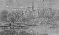
Image:Eglinton tournament bridge in 1843.jpg|<Center>Eglinton Castle & Bridge. This again shows the original three arched bridge, lake, etc. Circa 1843.<ref name="Wreath">''The Ayrshire Wreath MDCCCXLIII (1843):a collection of original pieces, in prose and verse, chiefly by native authors, on subjects relating to Ayrshire.'' Pub. H. Crawford & son. Kilmarnock. Facing Title page</ref> |
|||
</gallery> |
|||
=== The 'new' Tournament Bridge === |
|||
== atletiek en music== |
|||
<gallery> |
|||
De kluis is naar huis aan vele atletische teams/sporten met inbegrip van honkbal, dwarsland, het worstelen, binnen en openluchtspoorteams, voetbal, hockey, volleyball, zachte bal, de concurrentie cheerleading ploeg, basketbal, voetbal, dansteam, een stapteam, en een tennisteam. De kluis heeft vaak één van de beste voetbalteams in het centrale gebied. De panters bereikten ook een Regionaal kampioenschap door de hooglandlentes te verslaan en meadowbrook in de centrale gebiedbeslissingsmatches in 2007. Naast zijn hoogst geschat voetbalteam, is zijn band bekendst in de staat van Virginia. De het Marcheren Panters die onlangs voor Britse Koningin Elizabeth II, tijdens haar bezoek aan het Capitool in Richmond als deel van haar herdenking van de 400ste verjaardag van het oprichten van Jamestown worden uitgevoerd. |
|||
Image:Restored Tournament Bridge 1980.jpg|<Center>The Tournament bridge as restored in the 1980s. |
|||
Image:Tournament bridge in flood conditions.jpg|<Center>Flood conditions. |
|||
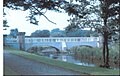
Image:Eglintontournamentbridge.JPG|<center>The Tournament Bridge over the Lugton Water in 2007. |
|||
Image:Tournamentbridge2.JPG|<center>The approach to the Tournament Bridge from the stables in 2007. |
|||
Image:Tournament Bridge benchmark.JPG|<Center>A [[benchmark]] on one of the bridge towers. |
|||
Image:Large Tournament bridge tower.JPG|<Center>One of the large bridge towers, probably recycled from the 1811 bridge. |
|||
Image:Small tournament bridge tower.JPG|<Center>One of the smaller towers with subtle design and carving differences suggesting a later date of construction. |
|||
Image:Vermiculate ashlar stonework Tournament Brdige.JPG|<Center>Vermiculate ashlar stonework on the abutment of the bridge at water level. |
|||
Image:Recycled stone Tournament Bridge.JPG|<Center>A reworked stone window ledge, possibly from Kilwinning Abbey, used in the weir at the central pier. |
|||
Image:Eglinton Tournament Bridge construction details.jpg|<Center>Details of how one of the recycled towers has been incoroprated into the new design. |
|||
Image:Hydrodemolition damage.JPG|<center>Hydrodemolition damage to the central pier. |
|||
Image:Recycled bridge stone.JPG|<Center>Recycled stones built into the weir beneath the bridge. One has the remains of two [[Corbel|corbels]] and may well have come from the pre-1802 medieval castle. |
|||
Image:Mason's mark.JPG|<Center>A Mason's Mark on the corbelled stone. |
|||
Image:Tournament Bridge piers.JPG|<Center>A cut water, possibly from the 'new bridge,' but removed during the 'army works.' |
|||
Image:Tournament Bridge old tower section.JPG|<Center>A section of an 'old' bridge tower used in the weir. |
|||
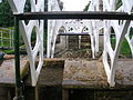
Image:Tournament Bridge weir.JPG|<Center>The weir made from sections of the old large 'towers.' |
|||
</gallery> |
|||
== The Tournament Bridge and WWII == |
|||
De 2007 centraal-regionale kampioeneninbreuk werd geleid door: Clayton SR QB/SS JUJU., WR Dominique Booker Sr., SR van Jamel Davis., Rb Justin White Sr., Jr. van de Middelen van TE/WR/DT Duan Perez, Jr. van WR/QB/SS Theron Norman. |
|||
The Eglinton Castle Estate was requisitioned during [[World War II]] and during this occupation the Tournament Bridge partly collapsed, partly due to alterations which had been made earlier by the Eglinton Estate, involving supposed strengthening using brickwork, as revealed during the 2008 restoration work.<ref name="NAC2">North Ayrshire Council, Roads and Transportation services. 2008</ref> The bridge was never designed to take the heavy army lorries and tanks which used the bridge during the army occupation of the site and this led to a partial collapse in the 1940s. To save the bridge from total collapse the army Royal Engineers Regiment removed the cast iron outer facia coverings and the pinnacles, encasing the remaining cast iron arches in concrete as can be seen from contemporary photographs and as further revealed during restoration work. It is not known what happened to the pinnacles and cast iron coverings. It had been thought that they were safely in storage, however enquiries have led to nothing.<ref name="NAC2">North Ayrshire Council, Roads and Transportation services. 2008</ref> |
|||
==== Repair work ==== |
|||
De defensie van 2007 Centraal-regionale Kampioenen werd geleid door: C Gus Espionsaza SR., Jr. van DL/OL Abu Kamara, SR van QB/SS Juju Clayton., Jr. van WR/SS Theron Norman, OB Justin Carr Sr., |
|||
<gallery> |
|||
Image:Tournament Bridge collapse, Eglinton Estate, Ayrshire.jpg|A view showing the partial collapse of the bridge. |
|||
Image:Tournament Bridge, Eglinton Estate, Ayrshire in the 1930s.jpg|Repair work underway, showing the shuttering for the concrete. |
|||
Image:Tournament Bridge repaired, Eglinton, Ayrshire.jpg|The repaired bridge. Note the simple wooden handrail and the remaining exposed iron arch. |
|||
Image:Tournament Bridge repaired, Eglinton Estate, Ayrshire.jpg|A view of the whole of the repaired bridge. Note the army personnel and lots of children fishing, etc. |
|||
</gallery> |
|||
== Other estate bridges == |
|||
De aanvallende Speler van de alle-Staat van Clayton Recieed van JuJu van het jaar, alle-gebiedspeler van het jaar, en Al districtsspeler van het jaar. gelukwensen JUJU, goed geluk in universiteit en Pros. |
|||
[[Image:Ainslie's Eglinton in 1790.JPG|left|thumb|<center>John Ainslie's 1790 map showing pleasure garden on the opposite side of the Lugton Water to the castle in what became part of the deer park.]] |
|||
[[Image:Eglinton in 1790.JPG|right|thumb|<center>John Ainslie's 1790 map showing pleasure garden on the opposite side of the Lugton Water to the castle in what became part of the deer park.]] |
|||
Originally the river would have been crossed by simple fords, however by the 18th century ornamental pleasure gardens had been formed and these were partly situated in what later became the deer park. No signs of these gardens are now visible, apart from [[Crop mark]]s on aerial photographs taken around the end of the Second World War. A bridge was necessary to give access to the ornamental gardens and one is indicated on John Ainslie's map dated 1790, crossing the Lugton Water close to the castle itself. A small wooden bridge across the Lugton Water is shown in an illustration from around 1815, however this may not have been across the Lugton Water. Thomson's map of 1828 (See illustration) indicates a bridge crossing the Lugton Water at the castle where the three arched bridge was and a drive starting off at the position of the present day bridge, which may have been a ford at the time. Another bridge is suggested further upstream and close to the castle.<ref name="Thomson">Thomson, John (1828). A Map of the Northern Part of Ayrshire.</ref> The wooden Laundry Bridge stood close to the castle and downstream from it was second wooden bridge which was washed away in a storm in 1938. Local children used it to build rafts. |
|||
[[Image:William Roy, Eglinton, 1747 - 55.jpg|left|200px|thumb|<Center>William Roy's 1747 - 55 map<ref name=Roy">Roy, William (1747 - 55) Military Map of Scotland.</ref> showing a bridge only upstream of the castle, roughly where Thomson also shows a bridge in his 1828 map.]] |
|||
[[Image:Eglinton by John Thomson 1828.jpg|right|thumb|200px|<Center>John Thomson's 1828 map showing the position of the old Tournamaent bridge. Here a drive and a possible building are located at the site of the 'new' Tournament Bridge.<ref name="Thomson">Thomson, John (1828). A Map of the Northern Part of Ayrshire.</ref>]] |
|||
The restored Stables Bridge, also called Lady Jane's Bridge, lies on the Kilwinning Lodge drive and just downstream from it stood an elegant cast-iron bridge with a 50 foot span.<ref name="Aiton2">Aiton, William (1811). Extract from the General View of the Agriculture of Ayr.</ref> This bridge had high quality stonework on both of the abutments, much of which survive. This bridge gave access to the kitchen walled gardens and glasshouse ranges and lasted into the mid 1940s when the army removed it. |
|||
The Suspension Bridge built by the army in the 1980s on behalf of the country park lies just below the weir beside the ruined gazebo. Lady Jane's cottage had a wooded pedestrian footbridge of which no sign remains. |
|||
In 1992-1993, leidde Matte Kellam, verlaten aanvallend wacht en midden linebacker, het de voetbalteam van de Panter tot een verslag 5-5. Zijn 5 ' 7" het 189 pondkader was een het opleggen plaats aan tegenpartijen. Mat ook zal herinnerd worden voor zijn geest en kleurrijk humeur. Hij werd sorely gemist van het de voetbalprogramma van de Panter voor de volgende 8 jaar aangezien de Kluis worstelde om een verslag boven .500 te posten. |
|||
The restored Diamond Bridge lies upstream near the Eglinton Loch and continues to give access to the old Toll Road from Irvine to Kilwinning via [[Fergushill]]. This bridge was named after the nearby Black Diamond mine, the spoil heap or bing of which still remains rear the Chapelholm Gate. The colliery name in turn was associated with one of the 13th Earl's favourite horses, Black Diamond. |
|||
De Middelbare school van de kluis heeft ook Marine JROTC Company van Kadetten. De Kadetten van de marine bij Kluis dragen de eenvormige Marine en opgeleid en in vaardigheden en kennis specifiek voor de Korpsen zoals boor, uitgebreide fysieke opleiding, scherpschutterskunst opleiding, en leidingsonderwijs opgeleid. De schoolreizen worden aangeboden meerdere keren per jaar bij de basissen van de Marine en van de Marine voor geavanceerde opleiding zoals levende brand (m-16 geweren), gaskamer opleidend gebruikend Cs en traangas, het rappelling, warfighting tactiek, mededelingen, logistiek, en landnavigatie. De eenheid biedt vele teams met inbegrip van een boor, colorguard, en scherpschutterskunstteam aan. |
|||
{{Clear}} |
|||
== A Gallery of the other bridges == |
|||
==Humanities Center== |
|||
<gallery> |
|||
Het centrum van Menswetenschappen is één van de Centra die van de Specialiteit van Provincie Henrico, zich op de verbinding tussen literatuur concentreren, geschiedenis, filosofie, en de art.Studenten in het Centrum van Menswetenschappen worden ook om hun humanitaire vaardigheden uit te oefenen omdat zij het vrijwilligerswerk elk jaar uitvoeren dat zij aan het centrum deelnemen. Het programma voorziet studenten van een kans om een strenge interdisciplinaire academische ervaring in de menswetenschappen na te streven terwijl de vervullende graduatieeisen ten aanzien van een geavanceerd diploma met een Centrum van de Specialiteit verzegelen. Men eist dat de studenten in dit centrum in de bespreking gebaseerde klassen met academisch geconcentreerde edelen bloeien, en omdat het centrum bij de Middelbare school van de Kluis wordt gevestigd, kunnen de studenten uit alle sporten, clubs, en middelen van een grote middelbare school ook voordeel halen. De kluis is ook naar huis aan de 2006 Kampioenen van het District van het Volleyball van Jongens. |
|||
Image:Lugtoneglintonbridge.JPG|<center>The suspension bridge over the Lugton Water. |
|||
Image:The Eglinton Suspension Bridge.JPG|<Center>The suspension bridge and cascade weir. |
|||
Image:Eglinton Lady Jane's cottage.jpg|<center>Lady Jane's cottage with its footbridge across the Lugton Water. |
|||
Image:Diamond Bridge restoration.jpg|<Center>The Diamond Bridge undergoing restoration. |
|||
Image:Eglinton Chapelholms bridge.JPG|<center>The Chapelholm or 'Diamond' bridge. |
|||
Image:Eglinton stables bridge.JPG|<center>The Stable's Bridge. |
|||
Image:Abutment of bridge in Eglinton.JPG|<Center>An abutment of the old Walled Garden bridge. Iron work is embedded in the structure, which was faced with high quality vermiculate ashlar stonework. |
|||
Image:Stucco stone from footbridge.JPG|<Center>A vermiculate<ref name="Vermiculate">[http://en.wikibooks.org/wiki/A_Researcher%27s_Guide_to_Local_History_Terminology Vermiculate stonework]</ref> stone from the ornate Walled Garden bridge. |
|||
Image:Laundry Bridge.JPG|<Center>The original Laundry Bridge in the 1900s. |
|||
Image:Castle Bridge side view.JPG|<Center>The 'new' castle or Laundry footbridge. |
|||
Image:Castle Bridge 1.JPG|<Center>The view across the Laundry or Castle Bridge. |
|||
</gallery> |
|||
== Lugton Water == |
|||
[[Image:Lugtoneglintonweir.JPG|right|thumb|230px|<center>The substantial weir on the Lugton Water near the Suspension Bridge in 2008.]] |
|||
[[Image:Weir at site of old Tournament Bridge.JPG|left|thumb|<Center>The Weir on the Lugton Water at the site of the old three arched Tournament Bridge.]] |
|||
The [[River Irvine|Lugton Water]] was diverted and altered several times, for example in the 1790s its course was altered by the 12th Earl (1740 - 1819)<ref name="IDC27">''Landscape of the Knights. The Eglinton Story.'' Rub. Irvine Development Corporation. 1992. P. 27.</ref> to run behind the Garden Cottage, rather than in front of it. The width was also changed at times, for instance five ponds or lakes were created by large weirs at one stage; the one at the Tournament Bridge is clearly visible in older prints of the 1840s (see illustrations) shown.<ref name = "Montgomeries79">Montgomeries of Eglinton. Ayr Division. Strathclyde Department of Education. P. 94.</ref> |
|||
The size, shape and position of the various weirs was altered several times, latterly by Clement Wilson of the canning factory. One of the weirs lies directly beneath the restored Tournament Bridge. The one below the site of the old [[Bowling Green]] and [[Robert Burns]]'s garden was 'U' shaped, holding back sufficient water at one time to form a lake with a small island bearing a single [[yew]] tree. The 1938 [[Ordnance Survey|OS]] map shows no fewer than seven weirs between the castle and the present day Suspension Bridge. |
|||
{{Clear}} |
|||
== The Clement Wilson gardens == |
|||
==Notable people== |
|||
[[Image:Yew tree weir, Lugton Water, Irvine, Scotland..jpg|right|thumb|<Center>The Clement Wilson Gardens in the 1970s.]] |
|||
*Alumni |
|||
In 1948 the Trustees of the late 16th Earl sold most of the remaining parts of the estate to Robert Howie and Sons of [[Dunlop]] for £24,000<ref name="IDC12">''Landscape of the Knights. The Eglinton Story.'' Rub. Irvine Development Corporation. 1992. P. 12.</ref><ref name="Sharp5">Sharp, Cameron (2007). ''Eglinton Country Park Management Plan for 2007 - 2011''. North Ayrshire Council. P. 5.</ref> and in the 1950s the Wilson family purchased the Tournament Bridge, old offices, castle ruins, and other land from Robert Howie and Sons. |
|||
**[[Shawn Barber]] <ref>[http://www.nflplayers.com/players/player.aspx?id=26030 http://www.nflplayers.com/players/player.aspx?id=26030]</ref> |
|||
**[[Orlando Jordan]] <ref>[http://pqasb.pqarchiver.com/washingtonpost/access/74068355.html?dids=74068355:74068355&FMT=ABS&FMTS=ABS:FT&date=DEC+13%2C+1992&author=Andrew+Backover&pub=The+Washington+Post&desc=WRESTLING%3B+Riverdale+Baptist+Wins+Six+of+13+Titles+at+Big+M]</ref> |
|||
**Troy Patterson, journalist{{Fact|date=November 2007}} |
|||
**[[Darren Sharper]], NFL safety for the [[Minnesota Vikings]].<ref>[http://www.wmalumni.com/notable_alumni/darren_sharper.shtml http://www.wmalumni.com/notable_alumni/darren_sharper.shtml]</ref> |
|||
**[[Jamie Sharper]], former NFL player. {{Fact|date=November 2007}} |
|||
**Scott Taylor <ref>[http://cubs.scout.com/a.z?s=260&p=8&c=1&nid=2143312 http://cubs.scout.com/a.z?s=260&p=8&c=1&nid=2143312]</ref> |
|||
*Staff |
|||
**Chester Fritz |
|||
Clement Wilson, the food processing factory owner, established the Clement Wilson Foundation which opened part of the grounds to the public, spending around £400,000 (around £4,317,000 in 2008 terms) on partially restoring the Tournament Bridge, consolidating the castle ruins, planting trees, landscaping, making paths, creating a rockery and waterfall feature, etc.<ref name="Wilson">Wilson, James (2008). Eglinton Archives - Written correspondence.</ref> |
|||
==References== |
|||
{{Reflist|2}} |
|||
== 2008 restoration == |
|||
==External links== |
|||
* [http://www.henrico.k12.va.us/HS/Hermitage/ Official site] |
|||
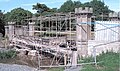
[[Image:Tournament Bridge 2008.jpg|thumb|The bridge partially dismantled and half way through hydrodemolition during renovation in May 2008.]] |
|||
* [http://www.highschoolsports.net/defaultcal_300.cfm?ct=2d&school=VA232284556&spt=-1&lvl=-1&division=-1&timezone=300 Hermitage H.S.], High School Sports |
|||
[[Image:Dam at Tournament Bridge.JPG|left|thumb|<Center>The temporary earth dam in the Lugton Water.]] |
|||
*[http://www.henrico.k12.va.us/HS/Hermitage/libindex.asp Hermitage H.S.], High School Library |
|||
The restoration of the Tournament Bridge involves a faithful and historic renovation of the Tournament Bridge, based on surviving documentary evidence. [[Historic Scotland]] requires a ‘faithful restoration where all details are replicated as closely as possible in terms of material, design and construction’. |
|||
*[http://www.henrico.k12.va.us/HS/Hermitage/humanities/ Hermitage H.S.], Humanities Center |
|||
[[Image:Turnament bridge repair.JPG|right|thumb|<Center>Close up of a repair to the cracked cast iron.]] |
|||
*[http://www.henrico.k12.va.us/HS/HermitageTech/ Hermitage], Technical Center |
|||
The existing concrete arches are to be removed as is the infill above. The arches will be replaced with the existing refurbished cast iron arch sections and new cast iron fascia sections, which will restore the original width of the structure. A secondary stainless steel pedestrian parapet is to be provided immediately behind the ballustrading. The load bearing capacity of the bridge will be carried by a modern steel structure concealed beneath the deck surface which will be timber, as this was considered to be the original material.<ref name=NACmins">[http://www.north-ayrshire.gov.uk/chiefexec/minutes.nsf/6939f82190c5aae2802572dd0046f16c/2e30178e790d6ec8802573f300400832?OpenDocument Minutes of North Ayrshire Council Executive Committee]</ref> |
|||
*[http://www.marchingpanthers.com/ Marching Panthers], Band Website |
|||
*[http://www.henrico.k12.va.us/hs/hermitage/ROTC/index.htm MCJROTC] |
|||
The current timber parapets will be replaced with cast iron sections to match the original items. All of the cast iron elements are to be fabricated and fitted by the Ballantine [[Bo'ness]] Iron Company to restore the splendour of the original structure.<ref name="Irvine Herald">The Irvine Herald, Friday 25th April, 2008. P. 10.</ref> |
|||
The restoration involved [[hydrodemolition]] to expose the cast iron arches through removing the concrete in which they had been embeded. This process used very high pressure water jets and confirmed the poor structural integrity of the iron arches. They were not however intended to be load bearing in the restored bridge and an upside was the degree of Gothic artwork found to exist on the arches.<ref name="NAC2">North Ayrshire Council, Roads and Transportation services. 2008</ref> |
|||
The estimated total project cost is £720k. Historic Scotland have indicated that they would be able to contribute some £161k, around £5k will be provided in kind, and the shortfall of £354k was the subject of the successful grant application to the [[Heritage Lottery Fund]].<ref name="NAC">[http://www.north-ayrshire.gov.uk/ChiefExec/CommRA07.nsf/e9ee67f48fbb9003802569d700533758/1f6211e0e2530ce4802573e60045da0f?OpenDocument North Ayrshire Council minutes and the Tournament Bridge restoration]</ref> |
|||
===2008 restoration gallery=== |
|||
<gallery> |
|||
Image:DSCN5379.JPG|<Center>Work begins. |
|||
Image:DSCN3137.JPG|<Center>A hydrodemolition operative in protective clothing. |
|||
Image:DSCN3200.JPG|<Center>A cast iron cross strut holding the arches together so they do not move sideways. |
|||
Image:Eglinton Tournament Bridge cast iron beams.jpg|<Center>Detail of the cast iron arches. |
|||
Image:DSCN3202.JPG|<Center>Detail of the Gothic ornamentation on the cast iron arches. Note the cracks in the ironwork. |
|||
Image:DSCN3208.JPG|<Center>The concrete decking prior to hydrodemolition and the exposure of the cast iron arches. |
|||
Image:DSCN3158.JPG|<Center>The concrete removed and the cast iron arches exposed. |
|||
Image:DSCN3078.JPG|<Center>Brickwork exposed between the cast iron arches. |
|||
Image:DSCN3163.JPG|<Center>Fully exposed cast iron arches. |
|||
Image:Eglinton Tournament Bridge construction details of pier.jpg|<Center>Details of the central pier's construction. |
|||
Image:Eglinton Tournament Bridge scaffolding.jpg|<Center>Ready for painting. |
|||
Image:Central pier Tournament Bridge.JPG|<Center>The white protective paint and the central pier. |
|||
Image:Tournament Bridge cutwater repairs.JPG|<Center>Repairs underway to the central pier and cutwaters. |
|||
Image:Iron stone binding.JPG|<center>An old iron stone block binding. These expanded as they rusted and ironically led to the loosening of the stonework. |
|||
Image:Eglinton Masons.JPG|<center>At work on the stone for the central pier. Note the craft tools. |
|||
Image:Tournament Bridge Mason.JPG|<center>Marking out a block before cutting out the design. |
|||
</gallery> |
|||
== See also == |
|||
*[[The Iron Bridge]] - the world's first iron bridge |
|||
== References == |
|||
{{Reflist|2}} |
|||
{{commonscat|Footbridges}} |
|||
[[Category:Blue Ribbon schools in Virginia]] |
|||
[[Category:High schools in Virginia]] |
|||
[[Category:Henrico County, Virginia]] |
|||
[[Category:Bridges in Scotland]] |
|||
P.S.- (9)-(1,13)-(11,9,18,1) |
|||
[[Category:Pedestrian bridges]] |
|||
[[Category:Gothic architecture|*]] |
|||
[[Category:History of North Ayrshire]] |
|||
Revision as of 18:37, 3 September 2008
Eglinton Tournament Bridge | |
|---|---|
 Tournament Bridge and castle in 1876[1] | |
| Coordinates | 55°38′41″N 4°40′12″W / 55.6446°N 4.6699°W |
| Carries | Pedestrians |
| Crosses | Lugton Water |
| Locale | Eglinton Country Park |
| Official name | Tournament Bridge |
| Maintained by | North Ayrshire Council Historic Scotland |
| Characteristics | |
| Design | Gothic |
| History | |
| Opened | c. 1845 |
| Location | |
 | |
The Eglinton Tournament Bridge is a bridge located within Eglinton Country Park near Kilwinning, North Ayrshire, Scotland. The bridge crosses the Lugton Water a short distance northwest of Eglinton Castle (OS ref: NS32064224) and was named after the Eglinton Tournament of 1839. The castle and surrounding grounds were once home to the Montgomerie family, Earls of Eglinton and chiefs of the Clan Montgomery.
History
The Tournament Bridges
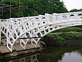
The surviving Tournament Bridge was built to provide an appropriate crossing point to gain access to the far side of the Lugton Water. Archibald Montgomerie, the 13th Earl of Eglinton had the bridge built in a Gothic style, using cast iron for the arches, pinnacles, etc. and stone for the two pairs of miniature ornamental towers at either end. These towers have subtle design differences (See photographs) which are significant in the context of the extended history of the bridge. This 'Tournament' bridge was designed by the architect David Hamilton. The bridge's cast iron parapet is a repetition of the pointed Gothic arch design of the castle, surmounted by a battlement, and relieved in the centre with foliated pinnacles.[2] The Tournament Bridge is B listed by Historic Scotland.[3]


The 1839 Eglinton Tournament was held on a meadow or holm at a loop in the Lugton Water. Most of the holm no longer exists, the excavations in this area having provided gravel and sand for the construction of the Kilwinning bypass and leaving behind an excavation pit which is now known as Eglinton Loch. The Knights on horseback and their retinue reached the tilt yard ('C' on the map) via an enclosed ride ('G' on the map), whilst the guests and visitors made their way to the stands via the route marked 'F' on the map illustrated. Both groups crossed over the previous three arched Gothic bridge. A map of 1837 of Eglinton Castle, Grounds and Tilt yard of 1837 shows that the tilt yard was already in extistence at this early date, but it is not recorded what its fate was after the tournament was over.[7]

The 'new' Tournament Bridge served as a well used route across the Lugton Water, running through the deer park to the Eglinton kennels (previously Laigh Moncur), especially on days when the Eglinton Hunt met at the castle itself.

The original bridge, also with two miniature towers, but with three arches and four pinnacles, stood roughly 100 yards further up the river towards the castle,[8] as shown in several contemporary prints and maps as illustrated in the appropriate gallery of this article.[9] It was this bridge that was used at the Eglinton Tournament as can be seen from the illustrations of the event, however the name was passed on to the 'new' bridge constructed downstream of it. No clear sign of this three arched bridge remains, a weir having been built at its old position; the 'old' bridge was constructed in 1811[10][11], therefore around the time of the 'new' castle being built in 1801/2 and also when the grounds were being laid out by Tweedie.
Surviving architects drawings show the designs for a three arched bridge and as stated, contemporary prints of the Eglinton Tournament also show a three arched Tournament bridge, with cast iron arches, pinnacles and parapets which may have been re-used in the later 'new' bridge which survives today.
The point at which the 'old' bridge crossed the Lugton was 102 feet broad and 100 yards downriver from the castle.[12] It had the Montgomerie coat of arms in the centre. Aiton describes it as being under construction in 1811.[13] The miniature castle towers on the demolished bridge are shown as each being surmounted by a double cross, but these do not figure on the 'new' Tournament Bridge; the 'old' bridge therefore may have been specially embellished for the tournament with temporary additions.


A local minister, the Rev. Lee Ker, confirms which bridge was used at the tournament by relating in his book on Kilwinning that the tournament procession passed over the Water of Lugton by what is now called the Tournament Bridge, but which was then situated about 100 yards nearer the Castle and had three arches instead of two.[16] This distance coincides with a weir today and an old path from the castle leads directly to it. Dane Love states that the bridge used by the tournament had been built by the 12th Earl in 1811.[17] In contemporary reports of the tournament no special mention of the bridge is made, suggesting that it was already a well established feature of the estate by that time and not an extravagant new feature specially built for the event.
Lauchlan[18] confuses the issue by stating that an older bridge with three arches existed 100 yards up from the present one, however he states that the present bridge was built for the tournament. The old three arched bridge in fact still existed in 1840[19] and at least as late as 1843.[20]
Construction of the 'new' Tournament Bridge
The new bridge may have been erected by the 13th Earl at some time between 1843 and 1856 as part of the total re-modelling of the course of the Lugton Water which had been first undertaken by the 12th Earl (1740 - 1819)[21] and which included the alteration of its course, the removal of the lakes or ponds and the creation of several weirs. The Lugton Water is liable to severe floods[22] and damage to the easily broken cast iron work by the force of the current, may have been a reason for its reconstruction at a different site. The first Ordnance Survey map of 1856 shows the two arched bridge in position, a weir at the position of the old bridge and by this time the old lake had gone, replaced by a canalised Lugton Water with several weirs.

Ironically the strengthening work done on the 'new' bridge to produce an extra arch of bricks in addition to the cast iron, may have weakened the structure, contributing to its eventual partial collapse.[23] The army used the bridge extensively with large lorries and even tanks crossong over it.
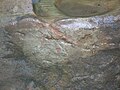
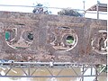
The lower courses of ashlar[24] on the bridge abutments and central pier were vermiculate.[25] At some point the height of the weir beneath had been raised using an odd assortment of re-used stonework; this would have increased the depth and extent of the waters behind it. The central pier and the original weir had used reworked but re-cycled stone, probably from Kilwinning Abbey; as illustrated by a stone window surround recovered during restoration work (See illustration).
Examination of the top of the outer towers shows that something was attached to the centres, the 'plug' hole still being present. It is possible that the holes are relate dto the method of lifting them into position during construction work. The larger towers are capped with cement and nothing is therefore visible. During restoration work (2008) electricity power cables or possibly gas pipes were located leading to the bridge and they may have served lights on top of some or all of the towers.[26] These are not visible in the available illustrations. The Eglinton estate had its own gasworks and later its own power station, so it would have been natural to provide lighting on the bridge. The old OS maps show that by 1897 the gas works had been established here to supply the castle and offices, whilst by 1911 this had been replaced by an electricity works; the present day park workshop.

The larger and taller inner towers appear to have been re-used from the older bridge, this being confirmed by the presence of ornate carving which is now obscured by the low wall leading to them from the smaller towers. The curtain walls and the smaller and lower outer towers are made from a different type of stone and, as stated, the towers have a number of architectural differences, suggesting that they were made specifically for the 'new' Tournament Bridge (See photographs). During work on the central pier it was found that some of the hidden infill work is vermiculate ashlar from the 'old' bridge.
The cast iron sections of the arches are numbered and some of the sequence are absent, suggesting that these missing sections may have been damaged previously beyond repair and were not used therefore in the 'new' bridge.
Older bridges gallery
-
A view of the castle and a wooden footbridge in 1815. -
Details of the wooden bridge. -
The castle and bridge in 1815. Three arches and a lake are depicted. -
![Eglinton Castle & Bridge. This again shows the original three arched bridge, lake, etc. Circa 1843.[27]](//upload.wikimedia.org/wikipedia/commons/thumb/0/08/Eglinton_tournament_bridge_in_1843.jpg/120px-Eglinton_tournament_bridge_in_1843.jpg)
Eglinton Castle & Bridge. This again shows the original three arched bridge, lake, etc. Circa 1843.[27]


![Eglinton Castle & Bridge. This again shows the original three arched bridge, lake, etc. Circa 1843.[27]](/wiki/File:Eglinton_tournament_bridge_in_1843.jpg)
The 'new' Tournament Bridge
-
The Tournament bridge as restored in the 1980s. -
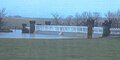
Flood conditions. -
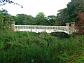
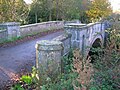
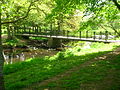
The Tournament Bridge over the Lugton Water in 2007. -
The approach to the Tournament Bridge from the stables in 2007. -
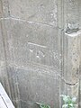
A benchmark on one of the bridge towers. -
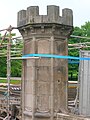
One of the large bridge towers, probably recycled from the 1811 bridge. -
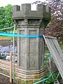
One of the smaller towers with subtle design and carving differences suggesting a later date of construction. -
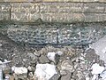
Vermiculate ashlar stonework on the abutment of the bridge at water level. -

A reworked stone window ledge, possibly from Kilwinning Abbey, used in the weir at the central pier. -

Details of how one of the recycled towers has been incoroprated into the new design. -
Hydrodemolition damage to the central pier. -

Recycled stones built into the weir beneath the bridge. One has the remains of two corbels and may well have come from the pre-1802 medieval castle. -
A Mason's Mark on the corbelled stone. -

A cut water, possibly from the 'new bridge,' but removed during the 'army works.' -

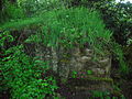
A section of an 'old' bridge tower used in the weir. -

The weir made from sections of the old large 'towers.'


The Tournament Bridge and WWII
The Eglinton Castle Estate was requisitioned during World War II and during this occupation the Tournament Bridge partly collapsed, partly due to alterations which had been made earlier by the Eglinton Estate, involving supposed strengthening using brickwork, as revealed during the 2008 restoration work.[28] The bridge was never designed to take the heavy army lorries and tanks which used the bridge during the army occupation of the site and this led to a partial collapse in the 1940s. To save the bridge from total collapse the army Royal Engineers Regiment removed the cast iron outer facia coverings and the pinnacles, encasing the remaining cast iron arches in concrete as can be seen from contemporary photographs and as further revealed during restoration work. It is not known what happened to the pinnacles and cast iron coverings. It had been thought that they were safely in storage, however enquiries have led to nothing.[28]
Repair work
-
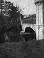 A view showing the partial collapse of the bridge.
 -
 Repair work underway, showing the shuttering for the concrete.
 -
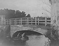 The repaired bridge. Note the simple wooden handrail and the remaining exposed iron arch.
 -
 A view of the whole of the repaired bridge. Note the army personnel and lots of children fishing, etc.


Other estate bridges


Originally the river would have been crossed by simple fords, however by the 18th century ornamental pleasure gardens had been formed and these were partly situated in what later became the deer park. No signs of these gardens are now visible, apart from Crop marks on aerial photographs taken around the end of the Second World War. A bridge was necessary to give access to the ornamental gardens and one is indicated on John Ainslie's map dated 1790, crossing the Lugton Water close to the castle itself. A small wooden bridge across the Lugton Water is shown in an illustration from around 1815, however this may not have been across the Lugton Water. Thomson's map of 1828 (See illustration) indicates a bridge crossing the Lugton Water at the castle where the three arched bridge was and a drive starting off at the position of the present day bridge, which may have been a ford at the time. Another bridge is suggested further upstream and close to the castle.[29] The wooden Laundry Bridge stood close to the castle and downstream from it was second wooden bridge which was washed away in a storm in 1938. Local children used it to build rafts.


The restored Stables Bridge, also called Lady Jane's Bridge, lies on the Kilwinning Lodge drive and just downstream from it stood an elegant cast-iron bridge with a 50 foot span.[12] This bridge had high quality stonework on both of the abutments, much of which survive. This bridge gave access to the kitchen walled gardens and glasshouse ranges and lasted into the mid 1940s when the army removed it.
The Suspension Bridge built by the army in the 1980s on behalf of the country park lies just below the weir beside the ruined gazebo. Lady Jane's cottage had a wooded pedestrian footbridge of which no sign remains.
The restored Diamond Bridge lies upstream near the Eglinton Loch and continues to give access to the old Toll Road from Irvine to Kilwinning via Fergushill. This bridge was named after the nearby Black Diamond mine, the spoil heap or bing of which still remains rear the Chapelholm Gate. The colliery name in turn was associated with one of the 13th Earl's favourite horses, Black Diamond.
A Gallery of the other bridges
-
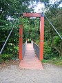
The suspension bridge over the Lugton Water. -

The suspension bridge and cascade weir. -

Lady Jane's cottage with its footbridge across the Lugton Water. -

The Diamond Bridge undergoing restoration. -

The Chapelholm or 'Diamond' bridge. -
The Stable's Bridge. -
An abutment of the old Walled Garden bridge. Iron work is embedded in the structure, which was faced with high quality vermiculate ashlar stonework. -
![A vermiculate[25] stone from the ornate Walled Garden bridge.](//upload.wikimedia.org/wikipedia/commons/thumb/a/ac/Stucco_stone_from_footbridge.JPG/120px-Stucco_stone_from_footbridge.JPG)
A vermiculate[25] stone from the ornate Walled Garden bridge. -
The original Laundry Bridge in the 1900s. -
The 'new' castle or Laundry footbridge. -

The view across the Laundry or Castle Bridge.


![A vermiculate[25] stone from the ornate Walled Garden bridge.](/wiki/File:Stucco_stone_from_footbridge.JPG)


Lugton Water


The Lugton Water was diverted and altered several times, for example in the 1790s its course was altered by the 12th Earl (1740 - 1819)[31] to run behind the Garden Cottage, rather than in front of it. The width was also changed at times, for instance five ponds or lakes were created by large weirs at one stage; the one at the Tournament Bridge is clearly visible in older prints of the 1840s (see illustrations) shown.[32]
The size, shape and position of the various weirs was altered several times, latterly by Clement Wilson of the canning factory. One of the weirs lies directly beneath the restored Tournament Bridge. The one below the site of the old Bowling Green and Robert Burns's garden was 'U' shaped, holding back sufficient water at one time to form a lake with a small island bearing a single yew tree. The 1938 OS map shows no fewer than seven weirs between the castle and the present day Suspension Bridge.
The Clement Wilson gardens

In 1948 the Trustees of the late 16th Earl sold most of the remaining parts of the estate to Robert Howie and Sons of Dunlop for £24,000[33][34] and in the 1950s the Wilson family purchased the Tournament Bridge, old offices, castle ruins, and other land from Robert Howie and Sons.
Clement Wilson, the food processing factory owner, established the Clement Wilson Foundation which opened part of the grounds to the public, spending around £400,000 (around £4,317,000 in 2008 terms) on partially restoring the Tournament Bridge, consolidating the castle ruins, planting trees, landscaping, making paths, creating a rockery and waterfall feature, etc.[35]
2008 restoration


The restoration of the Tournament Bridge involves a faithful and historic renovation of the Tournament Bridge, based on surviving documentary evidence. Historic Scotland requires a ‘faithful restoration where all details are replicated as closely as possible in terms of material, design and construction’.

The existing concrete arches are to be removed as is the infill above. The arches will be replaced with the existing refurbished cast iron arch sections and new cast iron fascia sections, which will restore the original width of the structure. A secondary stainless steel pedestrian parapet is to be provided immediately behind the ballustrading. The load bearing capacity of the bridge will be carried by a modern steel structure concealed beneath the deck surface which will be timber, as this was considered to be the original material.[36]
The current timber parapets will be replaced with cast iron sections to match the original items. All of the cast iron elements are to be fabricated and fitted by the Ballantine Bo'ness Iron Company to restore the splendour of the original structure.[37]
The restoration involved hydrodemolition to expose the cast iron arches through removing the concrete in which they had been embeded. This process used very high pressure water jets and confirmed the poor structural integrity of the iron arches. They were not however intended to be load bearing in the restored bridge and an upside was the degree of Gothic artwork found to exist on the arches.[28]
The estimated total project cost is £720k. Historic Scotland have indicated that they would be able to contribute some £161k, around £5k will be provided in kind, and the shortfall of £354k was the subject of the successful grant application to the Heritage Lottery Fund.[38]
2008 restoration gallery
-
Work begins. -
A hydrodemolition operative in protective clothing. -
A cast iron cross strut holding the arches together so they do not move sideways. -
Detail of the cast iron arches. -
Detail of the Gothic ornamentation on the cast iron arches. Note the cracks in the ironwork. -
The concrete decking prior to hydrodemolition and the exposure of the cast iron arches. -
The concrete removed and the cast iron arches exposed. -
Brickwork exposed between the cast iron arches. -
Fully exposed cast iron arches. -

Details of the central pier's construction. -
Ready for painting. -
The white protective paint and the central pier. -

Repairs underway to the central pier and cutwaters. -

An old iron stone block binding. These expanded as they rusted and ironically led to the loosening of the stonework. -

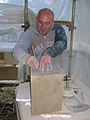
At work on the stone for the central pier. Note the craft tools. -
Marking out a block before cutting out the design.


See also
- The Iron Bridge - the world's first iron bridge
References
- ^ Dobie, James (1876). Pont's Cuninghame Pub. John Tweed.
- ^ Millar, A. H. (1885). The Castles and Mansions of Ayrshire.' Reprinted by The Grimsay Press (2004). ISBN 1-84530-019x. P. 74.
- ^ Historic gardens
- ^ Aikman, James (1839). An account of the tournament at Eglinton, revised and corrected by several of the knights : with a biographical notice of the Eglinton family to which is prefixed a sketch of chivalry and of the most remarkable Scottish tournaments. Pub. Edinburgh : H. Paton, Carver and Gilder. Facing P. 4.
- ^ Tait's Edinburgh Magazine. November 1839.
- ^ Stoddart, John (1801). Remarks on Local Scenery and Manners in Scotland during the years 1799 and 1800. Pub. William Miller, London. P. 313.
- ^ Anstruther, Ian (1986). The Knight and the Umbrella. An Account of the Eglinton Tournament 1839. Pub. Alan Sutton. Gloucester. ISBN 0-86299-302-4. P. III.
- ^ Ness, J. A. (1969 - 70). Landmarks of Kilwynnyng. Privately produced. P. 29.
- ^ Aitken, Robert (1829). The Parish Atlas of Ayrshire - Cunninghame. Pub. W. Ballantine. Edinburgh.
- ^ Close, Rob (1992), Ayrshire Buildings. Royal Incorporated Architects of Scotland. ISBN 1873-190-069. P. 64.
- ^ Ayrshire Roots
- ^ a b Aiton, William (1811). Extract from the General View of the Agriculture of Ayr.
- ^ Aiton, William (1811). Extract from the General View of the Agriculture of Ayr.
- ^ North Ayrshire Council, Roads and Transportation services. 2008
- ^ The Eglinton Tournament. Pub. Hodgson & Graves. London. 1840. P. 6.
- ^ Ker, Rev William Lee (1900). Kilwinning Pub. A. W. Cross, Kilwinning. P. 326.
- ^ Love, Dane (2003). Ayrshire: Discovering a County. Pub. Fort. Ayr. ISBN 0-9544461-1-9. P. 54.
- ^ Lauchlan, Roy (1989). Questions & Answers about the Montgomerie Family and the 1839 Tournaments. Pub. Kilwinning & District Preservation Society. P. 12.
- ^ Leighton, John M. (1850).Strath Clutha or the Beauties of the Clyde. Pub. Joseph Swan Engraver. Glasgow. Facing P. 229.
- ^ The Ayrshire Wreath MDCCCXLIII (1843): a collection of original pieces, in prose and verse, chiefly by native authors, on subjects relating to Ayrshire. Pub. H. Crawford & Son. Kilmarnock. Facing Title page.
- ^ Landscape of the Knights. The Eglinton Story. Rub. Irvine Development Corporation. 1992. P. 27.
- ^ The Eglinton Archive.
- ^ North Ayrshire Council, Roads and Transportation services. 2008
- ^ - Ashlar
- ^ a b - Vermiculate stonework Cite error: The named reference "Vermiculate" was defined multiple times with different content (see the help page).
- ^ North Ayrshire Council, Roads and Transportation services. 2008
- ^ The Ayrshire Wreath MDCCCXLIII (1843):a collection of original pieces, in prose and verse, chiefly by native authors, on subjects relating to Ayrshire. Pub. H. Crawford & son. Kilmarnock. Facing Title page
- ^ a b c North Ayrshire Council, Roads and Transportation services. 2008
- ^ a b Thomson, John (1828). A Map of the Northern Part of Ayrshire.
- ^ Roy, William (1747 - 55) Military Map of Scotland.
- ^ Landscape of the Knights. The Eglinton Story. Rub. Irvine Development Corporation. 1992. P. 27.
- ^ Montgomeries of Eglinton. Ayr Division. Strathclyde Department of Education. P. 94.
- ^ Landscape of the Knights. The Eglinton Story. Rub. Irvine Development Corporation. 1992. P. 12.
- ^ Sharp, Cameron (2007). Eglinton Country Park Management Plan for 2007 - 2011. North Ayrshire Council. P. 5.
- ^ Wilson, James (2008). Eglinton Archives - Written correspondence.
- ^ Minutes of North Ayrshire Council Executive Committee
- ^ The Irvine Herald, Friday 25th April, 2008. P. 10.
- ^ North Ayrshire Council minutes and the Tournament Bridge restoration