
Sørfjorden (Hardanger): Difference between revisions
Nordmensch (talk | contribs) m iw |
update for 2020 municipal-county changes |
||
| (6 intermediate revisions by 6 users not shown) | |||
| Line 1: | Line 1: | ||
{{Infobox body of water |
|||
{{Unreferenced|date=September 2009}} |
|||
| ⚫ | |||
[[File:Odda i februar 2004.jpg|thumb|250px|Sørfjorden viewed from Odda.]] |
|||
| other_name = |
|||
'''Sørfjorden''' is a 38 kilometre long [[fjord]] arm of the [[Hardangerfjord]] in [[Hordaland]] county, [[Norway]]. The longest arm of the Hardangerfjord, Sørfjorden stretches from north of [[Kinsarvik]] to the industrial town of [[Odda]]. The glacier of [[Folgefonna]] is located to its west, while the mountain plateau of [[Hardangervidda]] lies to its east. |
|||
| image = Odda i februar 2004.jpg |
|||
| alt = |
|||
| caption = View of the fjord, seen from [[Odda (town)|Odda]] |
|||
| image_map = |
|||
| caption_map = |
|||
| pushpin_map = Vestland#Norway |
|||
| pushpin_map_caption = Location of the fjord |
|||
| location = [[Vestland]] county, Norway |
|||
| coords = {{coord|60.1839|6.5711|region:NO_type:waterbody|display =inline,title}} |
|||
| type = |
|||
| inflow = |
|||
| outflow = [[Hardangerfjorden]] |
|||
| catchment = |
|||
| basin_countries = [[Norway]] |
|||
| length = {{convert|38|km}} |
|||
| width = {{convert|2.8|km}} |
|||
| area = |
|||
| depth = |
|||
| max-depth = |
|||
| volume = |
|||
| shore = |
|||
| frozen = |
|||
| islands = |
|||
| cities = [[Odda (town)|Odda]], [[Lofthus, Hordaland|Lofthus]], [[Kinsarvik]] |
|||
| reference = |
|||
}} |
|||
'''Sørfjorden''' is a {{convert|38|km|adj=on}} long [[fjord]] that is one of the innermost branches of the main [[Hardangerfjorden]]. It is located in [[Ullensvang Municipality]] in [[Vestland]] county, [[Norway]]. It is the longest arm that branches off of the Hardangerfjord. Sørfjorden stretches from just north of the village of [[Kinsarvik]] straight south to the industrial town of [[Odda (town)|Odda]]. The [[Folgefonna]] [[glacier]] and [[Folgefonna National Park]] are located just to the west of the fjord and the [[Hardangervidda]] mountain plateau lies to its east.<ref name="snl">{{cite web|url=http://snl.no/S%C3%B8rfjorden_%28Hordaland%29/i_Hardangerfjorden|title=Sørfjorden (Hordaland) – i Hardangerfjorden|author=Store norske leksikon|authorlink=Store norske leksikon|language=Norwegian|accessdate=2014-06-04}}</ref> |
|||
{{coord|60.24|6.59|display=title}} |
|||
{{Hordaland-geo-stub}} |
|||
Some of the notable villages that line the sides of the fjord include (north to south): [[Kinsarvik]], [[Lofthus, Hordaland|Lofthus]], [[Vikebygd, Ullensvang|Vikebygd]], [[Tyssedal]], [[Eitrheim]], and [[Odda (town)|Odda]]. [[Norwegian National Road 13]] follows the eastern shoreline of the fjord. All the villages along the fjord are filled with fruit farms and orchards, growing fruits like apples and cherries. |
|||
| ⚫ | |||
| ⚫ | |||
==Media gallery== |
|||
| ⚫ | |||
<gallery> |
|||
[[de:Sørfjord (Hardanger)]] |
|||
File:Lofthus Norwegen.JPG|View of the fjord in the Lofthus area |
|||
[[fi:Sørfjorden (Hardanger)]] |
|||
File:Lofthus1.jpg|Orchards overlooking the fjord |
|||
[[it:Sørfjorden]] |
|||
File:Sørfjorden, 2011 August.jpg|Looking south along the fjord |
|||
File:Sørfjorden Folgefonna.JPG|Looking east towards the Folgefonna glacier |
|||
[[no:Sørfjorden (Hardanger)]] |
|||
</gallery> |
|||
==See also== |
|||
* [[List of Norwegian fjords]] |
|||
==References== |
|||
{{reflist}} |
|||
{{authority control}} |
|||
| ⚫ | |||
| ⚫ | |||
[[Category:Ullensvang]] |
|||
Latest revision as of 00:40, 28 February 2020
| Sørfjorden | |
|---|---|
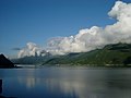
 View of the fjord, seen from Odda | |
 Sørfjorden Location of the fjord  Sørfjorden Sørfjorden (Norway) | |
| Location | Vestland county, Norway |
| Coordinates | 60°11′02″N 6°34′16″E / 60.1839°N 6.5711°E |
| Primary outflows | Hardangerfjorden |
| Basin countries | Norway |
| Max. length | 38 kilometres (24 mi) |
| Max. width | 2.8 kilometres (1.7 mi) |
| Settlements | Odda, Lofthus, Kinsarvik |
Sørfjorden is a 38-kilometre (24 mi) long fjord that is one of the innermost branches of the main Hardangerfjorden. It is located in Ullensvang Municipality in Vestland county, Norway. It is the longest arm that branches off of the Hardangerfjord. Sørfjorden stretches from just north of the village of Kinsarvik straight south to the industrial town of Odda. The Folgefonna glacier and Folgefonna National Park are located just to the west of the fjord and the Hardangervidda mountain plateau lies to its east.[1]
Some of the notable villages that line the sides of the fjord include (north to south): Kinsarvik, Lofthus, Vikebygd, Tyssedal, Eitrheim, and Odda. Norwegian National Road 13 follows the eastern shoreline of the fjord. All the villages along the fjord are filled with fruit farms and orchards, growing fruits like apples and cherries.
Media gallery[edit]
-
 View of the fjord in the Lofthus area
 -
 Orchards overlooking the fjord
 -
 Looking south along the fjord
 -
 Looking east towards the Folgefonna glacier


See also[edit]
References[edit]
- ^ Store norske leksikon. "Sørfjorden (Hordaland) – i Hardangerfjorden" (in Norwegian). Retrieved 2014-06-04.