
Hardangervidda
| Hardangervidda | ||
|---|---|---|
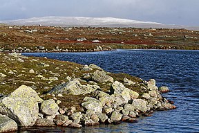
 Hardangervidda in summer |
||
| Highest peak | Sandfloeggi ( 1719 moh. ) | |
| location | Vestland , Viken , Vestfold og Telemark ( Norway ) | |
|
||
| Coordinates | 60 ° 3 ′ N , 7 ° 25 ′ E | |
| surface | 8,000 km² | |

The Hardangervidda is a plateaufjell in Norway and the largest plateau in Europe . It has an area of about 8000 km², an average altitude between 1200 m and 1400 m and extends over areas of the Fylke Viken in the northeast, Vestland in the west and Vestfold og Telemark in the southeast. At 1721 m, the Sandfloegga ridge is the highest point on the plateau. The Hårteigen mountain at 1690 m is a landmark .
description
Since 1981, 3422 km² of Hardangervidda - the largest national park in Norway - has been largely protected from human influences (see Hardangervidda National Park ).
The plateau is the remainder of a mountainous landscape that was abraded by glaciers during the Pleistocene Ice Age . The glaciers gave the plateau its current shape with wide plains, shallow lakes and a few gently rising peaks. Only in the higher western part, where the plain slopes down to Sørfjord and Eidfjord , there are more rugged sections.
Humans left the high plateau after the last Ice Age around 6000 BC. Settled . He probably followed the reindeer, who advanced with the receding ice on the fertile plain. Today tourism is an important economic factor on the Hardangervidda.
Flora and fauna
24 species of mammals and 114 species of birds have been recorded on the plateau .
Sheep breeding is practiced on the Hardangervidda . The largest wild reindeer herd in Norway with around 15,000 animals (as of 1996) lives in the Hardangervidda. The reindeer migrate in spring from the winter pastures in the east of the plateau to the higher, more nutritious summer pastures of the western Hardangervidda. There are snow owls , ptarmigan , arctic foxes , arctic hares , wolverines and a massive number of mountain lemings , the population of which increases by leaps and bounds every eleven to twelve years.
The precipitation-rich western part of Hardangervidda offers a Fjell relatively high plant wealth, while the eastern and northern part is rather barren further inland. More than 450 species of plants have been registered in Hardangervidda. These include some species that are otherwise only found in polar regions. The Hardangervidda is particularly known for the abundance of cloudberries .
Due to the extreme winter conditions, the plateau is the southernmost distribution area for many polar animal and plant species.

Glacier in the Hardangervidda in August
In September - first snow

Hardangervidda in winter

Street in Hardangervidda
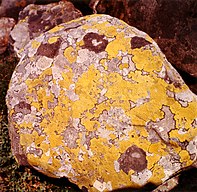
Map weaving on a rock of the Hardangervidda
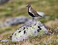
Golden Plover in August


Attractions

The most important sight in the Hardangervidda is nature in all its forms. Particularly impressive are u. a.
- the Hardangerjøkulen , a glacier in the northern Hardangervidda near Finse and
- the mountains of the Hardangervidda, such as the table mountain Hårteigen , and the Sandfloeggi , the highest peak of the plateau.
On the edge of the Hardangervidda, and in contrast to the core area, can usually be reached easily by car or public transport, there are other sights:
- Vøringsfoss , a waterfall near Eidfjord
- Hardangerfjord
- Middelalderuka (German: "Medieval Week") (July / August) in Numedal
Stave churches
There are several stave churches in the area around the Hardangervidda .
In Hallingdal :
- Torpo with the old Torpo stave church and the new church right next to it
- Hol
In Numedal :
museum
There are several museums in Hardangervidda:
- the Skinnarbu Nasjonalparksenter near the lake Møsvatnet in Tinn
- the Hardangervidda Nature Center in Eidfjord
- the Rallarmuseet about the history of the Bergensbanen in Finse
activities

- Trekking , skiing , cycling and hiking are popular holiday activities in the national park. There is an extensive network of managed, self-service (with food supplies) and unmanaged huts of the Norwegian hiking club DNT . There are also various private, managed mountain huts. In winter, however, these are usually closed until around mid-March. The everyone's right allows free camping and sleeping in nature.
- The troll railway is a small railway intended for excursions with children. It runs between Vøringsfoss and Måbø Gård Museum between June and August.
- Draisine ride on the disused Numedalbahn line.
- The Rallarvegen is one of the most beautiful cycle routes in Norway and runs largely parallel to the Bergen Railway . In some areas it is not easy to ride a bike, is closed to road traffic and is part of the national cycle route 4 .
- The Hardangervidda is the training room of the Forsvarets spesialkommando of the Norwegian Army .
traffic
Riksvei 7 leads over the Hardangervidda from the Hardangerfjord on the west coast of Norway to Geilo in Hallingdal . Since the road users on the route sometimes have to deal with drifting snow and icy roads in winter , Kolonnekjøring is often required in adverse weather conditions .
The regular-gauge railway line of the Bergen Railway runs from Oslo via Finse to Bergen over the high plateau. In the north-west, the Flåmsbana , which is now largely only relevant for tourism, leads from Flåm on the Aurlandsfjord in only 20 km up to Myrdal station, 800 m higher, on the edge of the Hardangervidda.
literature
- Svein Indrelid: Who hunted on the Hardangervidda? in: Archeology in Germany Issue 3/2013, pp. 30–33
- Tonia Körner: Norway: Hardangervidda , hiking guide, Conrad Stein Verlag, ISBN 978-3-86686-294-4
- Norway , Mair Dumont Baedeker , Astrid Feltes-Peter and Anja Carstanjen-Schroth, 2005, ISBN 3-8297-1065-8
- Norway , Mair Dumont Dumont, Michael Möbius and Annette Ster, 2006, ISBN 3-7701-7611-1
- Ministry of Foreign Affairs, Leif Ryvarden
Web links
- Overview map and huts of the DNT
- Hardangervidda Nature and Culture Center, Eidfjord (museum)
- Travel motives, travel behavior and perceptions of German tourists in Norway as the basis for the development of new concepts for the Norwegian tourism industry , dissertation, Thomas Kliem