Hol (Norway)
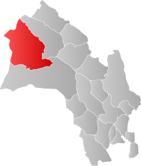
| coat of arms | map | |
|---|---|---|

|
|
|
| Basic data | ||
| Commune number : | 3044 | |
| Province (county) : | Viken | |
| Administrative headquarters: | Hol | |
| Coordinates : | 60 ° 37 ′ N , 8 ° 18 ′ E | |
| Surface: | 1,854.54 km² | |
| Residents: | 4,441 (Feb 27, 2020) | |
| Population density : | 2 inhabitants per km² | |
| Language form : | neutral | |
| Website: | ||
| politics | ||
| Mayor : | Petter Rukke ( Ap ) (2015) | |
| Location in the province of Viken | ||

|
||
Hol is a municipality in the province ( Fylke ) Viken in Norway . Hol has 4441 inhabitants (as of February 27, 2020) and extends over an area of 868 km². The administrative seat is the town of the same name.
coat of arms
The coat of arms was approved on July 5, 1991 and shows three silver anvils on a light blue background. They symbolize the formerly numerous blacksmiths in the area.
geography
Most of the residents live in the villages of Hol, Hovet , Geilo , Ustaoset and Haugastøl . Other localities are Dagali, Hagafoss and Kvisla.
Hol is bordered by the municipalities of Lærdal in the north, Ål in the north and east , Nore og Uvdal in the south and Eidfjord , Ulvik and Aurland in the west .
traffic
Geilo, Ustaoset and Haugastøl are stops on the Bergen Railway .
Worth seeing
- On the site of the old church in Hol, a small stave church was mentioned as early as 1328 . In the 16th, 17th and 18th centuries it was rebuilt and expanded several times. It was thoroughly renovated in 1888 and 1938. The baptismal font and the pulpit above the altar date from the Renaissance period (1697), the altarpiece from 1703.
- In the district of Dagali the open-air museum Dagali Museum .
Personalities
- Håvard Bøkko (* 1987), speed skater
- Ådne Søndrål (* 1971), speed skater
Web links
Commons : Hol - collection of images, videos and audio files

