Lunner
| coat of arms | map | |
|---|---|---|

|
|
|
| Basic data | ||
| Commune number : | 3054 | |
| Province (county) : | Viken | |
| Administrative headquarters: | Roa | |
| Coordinates : | 60 ° 14 ′ N , 10 ° 41 ′ E | |
| Height : | 420 moh. | |
| Surface: | 291.84 km² | |
| Residents: | 9,048 (Feb 27, 2020) | |
| Population density : | 31 inhabitants per km² | |
| Language form : | Bokmål | |
| Website: | ||
| traffic | ||
| Railway connection: | Gjøvikbanen | |
| politics | ||
| Mayor : | Harald Tyrdal ( Ap ) (2011) | |
| Location in the province of Viken | ||

|
||
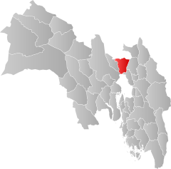
Lunner is a Norwegian municipality in Fylke Viken .
It is located in Fylke Viken and is administered by the village of Roa . Larger settlements are Grua, Harestua, Lunner and Roa. The highest point is the Bisflingflaka with a height of 691 meters. Lunner had 9048 inhabitants on February 27, 2020, the population density is 31 inhabitants per square kilometer. The area belonging to the municipality is 292 km² with a north-south extension of 23 km (with water 23.1 km) and an east-west extension of 16.2 km.
traffic
Lunner station is on the Gjøvikbane from Oslo to Gjøvik . It is regularly served by regional trains operated by the Norges Statsbaner .
The national road Riksvei 4 (Rv4) to Oslo also runs through the municipality.
Web links
Commons : Lunner - collection of images, videos and audio files
- statistical data on Lunner. Retrieved May 18, 2017 .
- Official website of the municipality of Lunner. Retrieved August 5, 2011 .


