Enebakk
| coat of arms | map | |
|---|---|---|

|
|
|
| Basic data | ||
| Commune number : | 3028 | |
| Province (county) : | Viken | |
| Administrative headquarters: | Kirkebygda | |
| Coordinates : | 59 ° 46 ' N , 11 ° 9' E | |
| Surface: | 232.58 km² | |
| Residents: | 11,110 (Feb 27, 2020) | |
| Population density : | 48 inhabitants per km² | |
| Language form : | Bokmål | |
| Website: | ||
| politics | ||
| Mayor : | Hans Kristian Solberg ( Sp ) (2019) | |
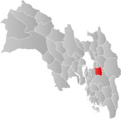
| Location in the province of Viken | ||

|
||
Enebakk is a municipality in the Norwegian province ( Fylke ) Viken with 11,110 inhabitants (as of February 27, 2020). The administrative seat is the village of Kirkebygda .
geography
Enebakk is located in the east of Fylkes Viken, on the west side of Lake Øyeren . In the south the municipality borders on Indre Østfold , in the north-west on Oslo . The population is now concentrated on the outskirts of the community. In the direction of Oslo and Ski lies the village of Ytre Enebakk and in the direction of Lillestrøm lies Flateby . The smallest of the three localities with over 200 inhabitants ( Tettsted ) is Kirkebygda in the southeast, which is the administrative seat of the municipality.
The highest point in the municipality is Vardåsen with a height of 374.1 moh. The north and west are part of the Østmarka forest area . The Riksvei 155, which creates the connection to Oslo, as well as the Riksvei 154 and the Riksvei 120 run through the municipality .
As in most of the province of Viken , the official language variant is Bokmål , the more widely used written language of Norwegian . The inhabitants of the commune are called Enebakking .
history
In Enebakk there is the Enebakk kirke, a church from the Middle Ages . Construction probably began as early as the 12th century, and the church was expanded in 1520.
The current borders of Enebakk have existed since 1962. At that time, part of the municipality was transferred to the municipality of Fet . Until the end of 2019, the municipality belonged to what was then Akershus Province . This was transferred to the newly created Fylke Viken on January 1, 2020 as part of the regional reform in Norway .
economy
In terms of agricultural production, dairy farming and grain cultivation are important for the municipality. Forestry is also important. Agriculture and forestry were traditionally the most important branches of the economy, today the majority of jobs are in the service sector. The majority of Enebakk's employees, however, worked outside the municipality, for example in Oslo, and the proportion of commuters is around 70 percent.
coat of arms
The coat of arms, officially used since 1986, shows four silver berries on a green background. The motif comes from a painting in Enebakk Church.
Personalities
- Ragnhild Jølsen (1875–1908), writer
- Thorleif Andresen (* 1945), racing cyclist
- Martine Ek Hagen (* 1991), cross-country skier
- Heidi Weng (* 1991), cross-country skier
Web links
- Enebakk in the store norske leksikon (Norwegian)
- Facts about Enebakk from Statistisk sentralbyrå (Norwegian)
Individual evidence
- ↑ Statistisk sentralbyrå - Befolkning
- ↑ a b c Geir Thorsnæs, Svein Askheim: Enebakk . In: Store norske leksikon . January 17, 2020 (Norwegian Bokmål, snl.no [accessed May 24, 2020]).
- ↑ Høyeste fjelltopp i hver commune. In: kartverket.no. Statens Kartverk, September 1, 2015, accessed on May 24, 2020 (Norwegian Bokmål).
- ↑ Forskrift om målvedtak i kommunar and fylkeskommunar (målvedtaksforskrifta) - Lovdata. In: Lovdata. January 6, 2020, accessed May 24, 2020 (Norwegian).
- ↑ Innbyggjarnamn. In: sprakradet.no. Språkrådet, accessed on May 24, 2020 (Norwegian Nynorsk).
- ↑ Enebakk kirke. In: Kirkesøk. Retrieved May 24, 2020 (Norwegian).
- ↑ Nye kommune- og fylkesnummer fra 2020. In: Regjeringen.no . Kommunal- og moderniseringsdepartementet, October 27, 2017, accessed on May 24, 2020 (Norwegian).
