Gjerdrum
| coat of arms | map | |
|---|---|---|

|
|
|
| Basic data | ||
| Commune number : | 3032 | |
| Province (county) : | Viken | |
| Administrative headquarters: | Ask | |
| Coordinates : | 60 ° 5 ' N , 11 ° 1' E | |
| Area: | 83.19 km² | |
| Residents: | 6,890 (Feb 27, 2020) | |
| Population density : | 83 inhabitants per km² | |
| Language form : | Bokmål | |
| Website: | ||
| politics | ||
| Mayor : | Anders Østensen ( Ap ) (2011) | |
| Location in the province of Viken | ||

|
||
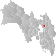
Gjerdrum is a municipality in the Norwegian Fylke Viken . The municipality has 6890 inhabitants (as of February 27, 2020) and is located in the greater Oslo area . The administrative seat is in Ask .
geography
Gjerdrum is located in the Romerike countryside in southeast Norway and borders on Nittedal in the west, Ullensaker in the east, Lillestrøm in the south and Nannestad in the north. On the eastern border with Ullensaker is the river Leira , whose tributary Gjermåa flows through the municipality from the north-west to the south-east. The highest elevation is the Prekestolen with a height of 410.6 moh. in the southwest of Gjerdrum.
population
Tettsted Grønlund, which also includes the Ask administrative center, is located in the municipality . A total of 5108 inhabitants live in Grønlund (as of 2020). An increase in population was recorded in the neighboring municipality of Ullensaker, especially after the construction of Oslo-Gardermoen Airport . Estimates by the statistical office Statistisk sentralbyrå assume further growth until 2040.
The inhabitants of the municipality are called Gjermsokning . As in many municipalities in Viken , the official written language is Bokmål , i.e. the more widespread of the two Norwegian language forms.
story
Until December 31, 2019 Gjerdrum belonged to what was then Akershus Province . As part of the regional reform in Norway, it was transferred to the newly created province of Viken on January 1, 2020.
In Gjerdrum is the Gjerdrum kirke , a church from 1686. It was built after the previous wooden church was destroyed in a fire in 1684. With the Heni kirke from 1864 there is another church in the parish.
On December 30, 2020, a landslide destroyed several residential buildings in the village of Ask. Several people were injured. Around 1000 people had to be evacuated because further landslides were feared. The landslide covered an area of 210,000 square meters. Heavy rains, which made the Quickton underground unstable, are considered to be a possible trigger . Initially, there were 21 missing people, but that number was later corrected to 10. Special forces searched the area with cell phones , thermal imaging cameras and drones for victims.
economy
Before the 1950s began to level the areas used for agriculture, largely no machines could be used there. Most of the land used for agriculture today is used for growing grain. In the field of animal husbandry, milk production is particularly important. Most of the forests belong to the state.
In 2019, of 3,627 people, only 805 worked in Gjerdrum itself, while 1,080 worked in the Norwegian capital, Oslo. Furthermore, many residents commuted to Skedsmo , Ullensaker and Lørenskog .
Coat of arms and name
The coat of arms of the municipality, which became official in 1993, shows a silver fence ( Norwegian : "gjerde") on a green background. The coat of arms alludes to the name of the municipality and also symbolizes agriculture and forestry.
The name is made up of the two components "Gerðr" and "vin", "vin" stands for "natural meadow".
Personalities
- Christian Krohg (1777–1828), lawyer and politician, member of the Storting
- Magne Hegdal (* 1944), composer, pianist and music critic
Web links
- Gjerdrum in the store norske leksikon (Norwegian)
- Facts about Gjerdrum from Statistisk sentralbyrå (Norwegian)
Individual evidence
- ↑ Statistisk sentralbyrå - Befolkning
- ^ Gjerdrum commune. In: Norgeskart. Kartverket, accessed August 30, 2020 (Norwegian).
- ↑ Høyeste fjelltopp i hver commune. September 1, 2015, accessed August 30, 2020 (Norwegian (Bokmål)).
- ↑ Tettsteders befolkning og areal, January 1, 2020. Statistisk sentralbyrå , October 6, 2020, accessed on November 14, 2020 (Norwegian).
- ↑ Kommunefakta: Gjerdrum. In: ssb.no. Statistisk sentralbyrå, accessed August 30, 2020 (Norwegian (Bokmål)).
- ↑ Innbyggjarnamn. Språkrådet, accessed August 30, 2020 (Norwegian (Nynorsk)).
- ↑ Forskrift om målvedtak i Kommunar og fylkeskommunar (målvedtaksforskrifta). In: Lovdata. January 6, 2020, accessed August 30, 2020 (Norwegian).
- ↑ Kommunal- og moderniseringsdepartementet: Nye kommune- og fylkesnummer fra 2020. In: regjeringen.no. October 27, 2017, accessed August 30, 2020 (Norwegian).
- ↑ Gjerdrum kirke. In: Kirkesøk. Retrieved August 30, 2020 (Norwegian).
- ↑ Heni kirke. In: Kirkesøk. Retrieved August 30, 2020 (Norwegian).
- ↑ Eirik Husøy, Per-Helge Berg: Innsatsleder i Gjerdrum: - Søket er fortsatt en redningsaksjon. In: Nettavisen . December 31, 2020, accessed December 31, 2020 (Norwegian).
- ↑ Several injured and missing persons after landslide. In: The time. December 30, 2020, accessed December 31, 2020 .
- ↑ Politiet: 21 personer er ikke gjort speech for etter raset i Gjerdrum. NTB, December 30, 2020, accessed on December 31, 2020 .
- ↑ 10 people savnet etter jordskred - advance nå å send ned dogs. vg.no, December 30, 2020, accessed on December 31, 2020 (English).
- ↑ a b Svein Askheim, Geir Thorsnæs: Gjerdrum . In: Store norske leksikon . August 20, 2020 (Norwegian, snl.no [accessed August 30, 2020]).
- ↑ Pendlingsstrømmer. Statistics Norway, accessed August 30, 2020 (Norwegian).
- ↑ Gjerdrum. In: Norsk stadnamnleksikon. Retrieved August 30, 2020 (Norwegian).

