Ringerike
| coat of arms | map | |
|---|---|---|

|
|
|
| Basic data | ||
| Commune number : | 3007 | |
| Province (county) : | Viken | |
| Administrative headquarters: | Hønefoss | |
| Coordinates : | 60 ° 11 ′ N , 10 ° 13 ′ E | |
| Surface: | 1,555.11 km² | |
| Residents: | 30,641 (Feb 27, 2020) | |
| Population density : | 20 inhabitants per km² | |
| Language form : | Bokmål | |
| Postal code : | 3501-3534 | |
| Website: | ||
| politics | ||
| Mayor : | Kirsten Orebråten ( Ap ) (2019) | |
| Location in the province of Viken | ||

|
||
Ringerike is a municipality in Norway in the province ( Fylke ) Viken . It has 30,641 inhabitants (as of 30,641).
geography
The municipality of Ringerike covers the area to the north and west of the Tyrifjord . The Begna River flows from the Jotunheimen Mountains through Ringerike into the fjord. The lakes Storflåtan and Sperillen are in the municipality . In the southeast, Ringerike borders on the municipality of Oslo . It also shares a border with Sør-Aurdal , Søndre Land , Gran , Lunner , Jevnaker , Bærum , Hole , Modum , Krødsherad and Flå .
The highest elevation of the commune is the Gyranfisen with 1126.7 moh. in the northwest of the municipality. From the north the area drops steeply towards the lowlands in the south. The southeastern and central part of Ringerike belongs to the Oslograben .
The largest town is the administrative center of Hønefoss . Other settlements are Hallingby, Helgelandsmoen, Nakkerud, Norderhov, Sokna, Tyristrand and Vang. The inhabitants of Ringerike are called Ringeriking . As in most municipalities in the province of Viken, the official language is the written language Bokmål .
The Bergensbanen railway runs through Hønefoss. It is planned to complete the so-called Ringeriksbanen by 2029, which should shorten the travel time between Hønefoss and Oslo. Important roads that run through the municipality are European route 16 , Riksvei 35, which connects with Tønsberg , and Riksvei 7, which connects Hønefoss to Bergen .
history
The municipality of Ringerike was created on January 1, 1964 from the amalgamation of the previous municipalities of Hønefoss , Hole , Norderhov, Ådal and Tyristrand. In 1977 Hole was separated from Ringerike again and again declared an independent municipality. Ringerike belonged to the former Buskerud Province until December 31, 2019 . As part of the regional reform in Norway, this was transferred to the newly created Viken Province.
There are archaeological finds in Ringerike that date back to the Stone Age . There is a church in Norderhov that was completed in the 12th century.
economy
In addition to public administration and the service sector , trade in goods and the accommodation industry are important employers. This is mainly because Hønefoss is a trading center and tourism plays a bigger role. The headquarters of the Norwegian cartography authority , the Kartverket, are located in Hønefoss . Wood processing has long been one of the most important sectors in industrial production . However, this became insignificant with the closure of the Follum factory of the paper manufacturer Norske Skog .
Grain cultivation is of particular importance for agriculture. Animal husbandry is mainly found in the area of cattle , pigs and chickens . With 220,800 m³ of harvested wood , Ringerike was also the municipality with the highest yield in what was then Fylke Buskerud in 2015 .
There are ten power plants in Ringerike , which together had an average annual production of 525 gigawatt hours in 2016. The largest of these is the Hofsfoss power plant with an average annual production of around 141 gigawatt hours. It was put into operation in 1978.
coat of arms
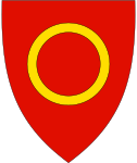
The coat of arms shows a gold ring on a red background and was confirmed in 1967. The colors red and gold, the royal colors of Norway, represent royalty. The ring is a speaking symbol and at the same time symbolizes the unity of the area, which has been a unity since the Middle Ages.
Personalities
- Tora Berger (* 1981), biathlete
- Vetle Sjåstad Christiansen (* 1992), biathlete
- Fredrik Wilhelm Gomnaes (1868–1925), composer
- Mads Kaggestad (* 1977), racing cyclist
See also
Web links
- Kommune Ringerike in the store norske leksikon (Norwegian)
- Facts about Ringerike from Statistisk sentralbyrå (Norwegian)
Individual evidence
- ↑ Statistisk sentralbyrå - Befolkning
- ↑ Høyeste fjelltopp i hver commune. Kartverket, September 1, 2015, accessed February 27, 2020 (Norwegian Bokmål).
- ↑ Innbyggjarnamn. Språkrådet, accessed February 27, 2020 (Norwegian).
- ↑ Forskrift om målvedtak i kommunar and fylkeskommunar (målvedtaksforskrifta) - Lovdata. Lovdata, accessed February 27, 2020 .
- ↑ Ringeriksbanen og E16 - fellesprosjektet - Bane NOR. Bane Nor, accessed February 27, 2020 (Norwegian).
- ^ Ringerike commune. Visit Innlandet, accessed February 27, 2020 (Norwegian Bokmål).
- ↑ Nye kommune- og fylkesnummer fra 2020. Kommunal-og moderniseringsdepartementet, October 27, 2017, accessed on February 27, 2020 (Norwegian).
- ↑ Norderhov Kirke. In: visitnorway.no. Retrieved February 27, 2020 (Norwegian).
- ↑ Om Kartverket. Kartverket, September 26, 2012, accessed on February 27, 2020 (Bokmål in Norwegian).
- ↑ Vannkraftverk - NVE. In: nve.no. Reguleringsmyndigheten for energi (RME), accessed February 27, 2020 (Norwegian).
