Aurland
| coat of arms | map | |
|---|---|---|

|
|
|
| Basic data | ||
| Commune number : | 4641 | |
| Province (county) : | Vestland | |
| Administrative headquarters: | Aurlandsvangen | |
| Coordinates : | 60 ° 54 ' N , 7 ° 11' E | |
| Surface: | 1,467.7 km² | |
| Residents: | 1,781 (Feb 27, 2020) | |
| Population density : | 1 inhabitant per km² | |
| Language form : | Nynorsk | |
| Website: | ||
| politics | ||
| Mayor : | Trygve Skjerdal ( Sp ) (2019) | |
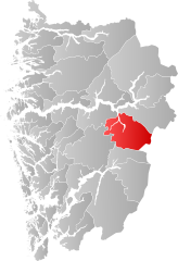
| Location in the province of Vestland | ||
|
||
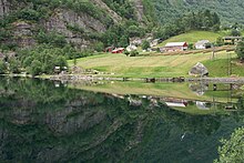
Aurland is a municipality in the province Vestland in Norway . Aurlandsvangen on the Aurlandsfjord is the administrative center of the municipality. Sometimes the place itself is called Aurland for short.
geography


Geographical location
Aurland's nature is characterized by a mountain landscape. 80% of the area is over 900 meters above sea level ( moh. ). The fjords Aurlands- and Nærøyfjord cut into the landscape . Both are tributaries of the longest and deepest fjord in Norway, the Sognefjord . The mountains Styvisdalseggi , Storebreen , Syrdalsbreen , Flenjaeggi and the Blåskalven rise next to them . With 1,809 moh. the highest elevation in the community. As a continuation of the Nærøyfjord, the Nærøydal connects . This is where Gudvangen is located . The river Nærøydalselvi crosses the valley and forms partly deep gorges due to the geological conditions . At the end of the Aurlandsfjorden rises the Flåmsdal , with the place Flåm . The Flåmselvi river crosses this valley . Glacier pots from the last ice age have been preserved in Flåmsdalen . The main town Aurlandsvangen is located on the western side of the Aurlandsfjorden. After the Aurlandselvi has flowed through the Aurlandsdal, it flows into the fjord here. Undredal is located on the peninsula between the two fjords and the mountains Syrdalsbreen and Flenjaeggi . A river, the Undredalselvi , also flows through the valley . The place Undredal lies at the foothills of the valley on the Aurlandsfjorden. Almost the entire area of the municipality belongs to the mountainous region of Nordfjella, which has also been called Skarvheimen since 1995 . Only the extreme north-west from the Nærøyfjorden is excluded. In this mountainous region there are several larger and smaller lakes, for example Store Liavannet , Nyhellervannet , Stora Vargevannet and Fretheimsdalsvatnet .
geology
Aurland is located in Jotunheimen , the southern and highest part of the Scandinavian Mountains . The Scandinavian Mountains are one in the tertiary prominent large plaice on the western edge of the Baltic Shield . The geology of Aurland is characterized by various more or less intensely folded and more or less strongly metamorphic rocks. These form three superimposed tectonic units: a autochthonous Precambrian Basement complex as the lowest unit, a Caledonian deformed, allochthonous Cambro - silurian Metasedimentkomplex and the Caledonian Jotun- ceiling represents the Allochthonous präkambrisches Basement, as the highest unit. Autochthonous basement and metasediment units emerge over large areas in so-called tectonic windows in some parts of the municipality .
The autochthonous Precambrian basement bites mainly in the central part and in the northeast of Aurland, u. a. in the lower section of the Aurlandsdalen as well as in some side valleys, where glaciers and rivers have cut deep into the mountains and cleared the higher tectonic units. The basement unit is made up of various gneisses and mostly light-colored biotite granites and granodiorites , which have their origins in Precambrian mountain formations .
The rocks of the metasediment unit encircle the rocks of the basement unit and pull themselves. a. over the upper Aurlandsdalen to the south and east edge of the municipality. These are mica slate as well as phyllites and quartz phyllites and, to a lesser extent, marble . The thickness of this unit varies between a few meters and several hundred meters as a result of the folding and thrusting processes that took place during the Caledonian mountain formation.
The Jotun Nappe represents the majority of the surface rocks in Aurland. It represents the Precambrian basement, which was pushed over the metasediment unit during the Caledonian mountain formation. It consists mainly of igneous rocks, some of which have been converted into gneisses and amphibolites . Anorthosites and monzonites are very common . In some places, however, metasediments in the form of quartzites and paragneisses also occur in this unit.
Neighboring communities
The municipality of Aurland is located in the east of the Vestland province, which was formed on January 1, 2020 from the previous provinces of Sogn og Fjordane and Hordaland . Aurland is located in the former province of Sogn og Fjordane, bordering the municipality of Vik in the northwest and the municipality of Lærdal in the northeast . To the east is the municipality of Hol in the province of Viken . In the south and south-west it borders on the municipalities of Ulvik and Voss .
Protected areas
Hallingskarvet National Park
The large Hallingskarvet National Park only touches Aurdal in the extreme south. Only the Vargabreen glacier is located in the municipality's catchment area.
Bleia-Storebotn landscape protection area
The Bleia-Storebotn landscape protection area was established on October 8, 2004 and covers a total of 66 km². The area is located in both Aurland and Lærdal municipality. It is located in the north of Aurland and extends from Aurlandsfjorden over the mountains Breisnesnosi , Kalvnesnosi , Støkkarberg , Handkiefjellet and Nisedalsfjellet over the plains Kolarbotn and Storebotn to the border of Lærdal. The Grånosi mountain is also in the catchment area, while the Djupedalene is excluded from it. The protected area includes the natural and cultural landscapes of the fjords, plains and mountains with rich vegetation and a wild reindeer population .
Nærøyfjord Protected Landscape Area
The nature reserve Nærøyfjorden was established on November 8, 2002 and covers 576 km². Since 2005 it belongs together with the Geirangerfjord under the title West Norwegian Fjords to the World Heritage of UNESCO . The area is mainly in the municipality of Aurland. 35 km² are spread over the municipality of Voss and the remaining area is located around the Fresvikbreen in the municipality of Vik. In Aurland, the area extends from the northern and western borders to the Aurlandsfjorden and Flåmsdalen. The sanctuary includes both natural and cultural landscapes, with fjord, mountain and glacier landscapes. In addition to the diverse flora and fauna, the region includes active arable and pasture areas as well as cultural assets, for example alpine farms and the old royal postal route.
local community

Surname
The name Aurland is derived from the Old Norse word aurr and means pebble or gravel.
coat of arms
The coat of arms shows a silver-colored goat's head on a blue background. The coat of arms is intended to emphasize the importance of keeping goats in the community.
Tusenårssted
The location of the former Rygg Church ( Norw. Rygg kyrkja ) was designated as Tusenårssted . The stave church was built in the Middle Ages and demolished in the second half of the 16th century. However, the cemetery continued to be used until 1806. A pile of stones, the history of which has not been fully clarified, is supposed to mark the place where the church once stood. The local historian Anders Ohnstad is of the opinion that this pile of stones served as a memory of a rich man before the church was built. Another stone, the so-called Bønestein, is said to have been the meeting point for the last six to seven survivors of the plague (1347–1351) in Aurland. In 1950 a building stone was erected to honor the square. The church grounds are now a listed building . The committee chose the location because of its long cultural history and its central importance for Aurland.
places
The places Aurland developed mainly in the valleys by the fjord. Before the construction of the Bergensbanen (and later the Flåmsbana ), the villages could only be reached by water and on foot via the royal mail route in Nærøydalen. At the Nærøyfjord, Dyrdal emerged as a trading town where the Thing was also held. The residents of Næroyfjorden shared the church with the residents of Undredal until Bakka got its own church in 1859. Tourism developed very early in Gudvangen and Flåm on the Aurlandsfjorden . Today Aurlandsvangen is the only crime scene in the municipality and Dyrdal has lost its position as a commercial and legal town.
population

The population of Aurland is mainly concentrated in the valleys. The administrative seat of Aurlandsvangen is the only Tettsted in the municipality.
Population development in the municipality of Aurland
Famous pepole
- Absalon Pederssøn Beyer - eminent humanist and theologian
- Per Sivle - writer
Economy and Infrastructure

traffic
Up until 1980 Aurland could only be reached in winter via the Flåm Railway or by boat. The situation only improved with the opening of the road to Hallingdal in 1980. 1991 direction were mountains of Flenjatunnel and Gudvanga Tunnel opened in June 2001, the Lærdalstunnelen to Lærdal . The latter is currently (2013) the longest road tunnel in the world with over 24 km. This created a continuous winter-proof road connection ( E16 ) from Oslo to Bergen. Today, Aurland lies directly on this important connection for Norway. The old road over the mountains to Lærdal is called Snøvegen and is now only used as a side road. The next place from Aurlandsvangen towards Bergen is Flåm, a well-known tourist destination.
economy
Agriculture
Aurland is traditionally shaped by agriculture . The intensive land use with fields and pastures was mainly concentrated in the narrow valleys of Aurland. The cultural landscape was divided into several rows of arable land. By selling, leasing and inheriting the fields, they were partially fragmented and so the areas of a user were often small and far apart. That made intensive cultivation difficult. The courtyards came together in groups or rows in order to share the many differently specialized economic areas. The Otternes open-air museum between Flåm and Aurlandsvangen gives an impression of this . Winter feed, such as leaves, hay, twigs and moss, is often brought from the neighboring countryside , in Norway and outdoor Mark (norw .: Utmark ) called. Firewood and construction wood were obtained from the forest . Both the forest and the outer market were important for the production of tar and charcoal . The outer market was also partially used as pasture. Small groups of birch trees were cultivated on the open, grass-dominated pastures , and elms and linden trees were also planted in protected areas . Years of use of the trees gave them a thick, corkscrew-shaped growth. Trees with straight growth were therefore of high value. Such groups of birch trees still exist on the alpine pastures Steine and Vassbygdi . Remnants of the groves can still be seen on Skjerdal and Holmo . Today mainly goats are kept in the pastures, in the past mixed animal husbandry, including sheep, was common. Each farm ran several alpine pastures. Often one or two spring pastures on the edge of a wood and a Sommeralm in the mountains, the Fjell . The Niederleger and mountain pastures Sinjarheim , Øvstebo and Nedbergo have been partially preserved. The fell was used for hunting and grazing. Intensive use also left its mark on this landscape. The tree line was lowered towards the valley by grazing and cutting down.
Industry
Since the first half of the 20th century, the Aurland shoe (Norwegian: Aurlandssko) has been manufactured industrially in Aurland . In the beginning many small workshops produced it, today only the Aurlands Schuhfabrik still exists in Aurlandsvangen. In the visitor center Aurlandskoen Èconomusèe you can see the traditional production of the shoe.
There is an anorthosite mining area in Nærøydalen.
Construction of a hydropower plant in Aurlandsdal began in the summer of 1969. 20 years later, five power plants and 11 dams were completed. 37 mountain lakes were integrated into the system and produced 2.6 TWh in the year of completion. The top magazine is at 1,450 moh. The bottom Vangen power plant remains out of order in summer out of consideration for nature. The construction was not without controversy, as nature is an important part of tourism in Aurland. The Oslo Lysverker company bought the fall rights for the Aurland river system in 1945. Today the hydropower plants are operated by the companies E-CO Energi , E-CO Vannkraft and Oslo Lysverker .
tourism
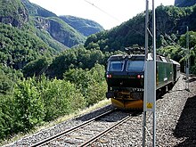
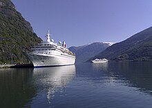
Tourism started early in Aurland. In Dyrdal and Gudvangen there has been a guest house since 1737. These coexisted until the 19th century, before Gudvangen became the center. The place of Dyrdal lost its importance and the guest house was demolished over 200 years later, in 1939. In the 1860s the Fretheim Touristhotell was built in Flåm and Aurlandsvangen also had a guest house. The English Lord Garvagh came to Aurland with his entourage to indulge in sport fishing and reindeer hunting. In Gudvangen and Flåm the importance of tourism steadily increased, especially after the completion of the Flåmsbana, which now connected Aurland with Bergen and Oslo . With the expansion of the quayside, large cruise ships are increasingly coming to the region and tourism is becoming an increasingly important source of income.
Culture and sights
- Flåmsbanmuseet Railway Museum
- Otternes open-air museum
- Rallarvegen cycle and hiking trail
- Undredal Stave Church
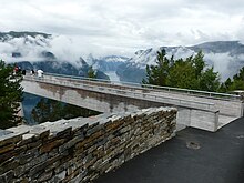
- Stegastein viewing platform
Web links
Individual evidence
- ↑ Statistisk sentralbyrå - Befolkning
- ↑ a b c d Aurland. In: store norske leksikon. Retrieved July 6, 2014 (Norwegian).
- ↑ Kulturhistorisk vegbok Sogn og fjordane Aurland . Naustdal: Sogn og Fjordane forl., 1991, ISBN 82-91082-00-6 , p. 7 .
- ^ A b c d Noralf Rye, Per Einar Faugli: Geology and geomorphology of the Aurland district. Norsk Geografisk Tidsskrift - Norwegian Journal of Geography. Vol. 48, No. 1-2, 1994, pp. 13-22, doi : 10.1080 / 00291959408552322 .
- ↑ a b Bleia-Storebotn LVO. Stiftinga Geirangerfjorden Verdsarv, accessed July 7, 2014 (Norwegian).
- ↑ Nærøyfjorden landskapsvernområde. Miljøstatus, archived from the original on July 14, 2014 ; Retrieved September 26, 2019 (Norwegian).
- ↑ Rygg kyrkja - Tusenårstaden i Aurland. Aurland Kommune, accessed July 7, 2014 (Norwegian).
- ↑ Kulturhistorisk vegbok Sogn og fjordane Aurland . Naustdal: Sogn og Fjordane forl., 1991, ISBN 82-91082-00-6 , p. 12, 20/21 .
- ↑ Kulturhistorisk vegbok Sogn og fjordane Aurland . Naustdal: Sogn og Fjordane forl., 1991, ISBN 82-91082-00-6 , p. 5/6 .
- ^ Aurlandskoen. visitflåm, accessed July 7, 2014 (Norwegian).
- ↑ a b Kulturhistorisk vegbok Sogn og fjordane Aurland . Naustdal: Sogn og Fjordane forl., 1991, ISBN 82-91082-00-6 , p. 33 .
- ↑ AURLAND - et gigantanlegg i verdensmålestokk. (PDF; 370 kB) E-CO, 2010, archived from the original on March 12, 2018 ; Retrieved September 14, 2019 (Norwegian, original website no longer available).
- ↑ Kulturhistorisk vegbok Sogn og fjordane Aurland . Naustdal: Sogn og Fjordane forl., 1991, ISBN 82-91082-00-6 , p. 12, 19, 22-25 .


