Hordaland
| coat of arms | map | ||
|---|---|---|---|

|
|||
| Basic data | |||
| Country : | Norway | ||
| Administrative center : | Mountains | ||
| Area : | 15,436.64 km² | ||
| Residents : | 524,495 (January 1, 2019) | ||
| Population density : | 32.7 inhabitants / km² | ||
| Municipalities : | 33 | ||
| ISO 3166-2 | NO-12 | ||
| Fylkesstein : | Coronite | ||
| politics | |||
| Fylkesordfører : | Anne Gine Hestetun (Ap) | ||
| Fylkesmann : | Lars Sponheim (V) | ||
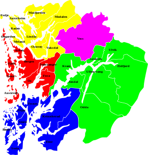
 Districts of Hordaland:
|
|||
Hordaland was a province ( Fylke ) in Norway . 524,495 people lived here on 15,436 km² (as of January 1, 2019). The capital of Hordaland was Bergen . In Hordaland, the Hardangerfjord was one of the longest and deepest fjords on the Norwegian coast.
Before the reform of 1919, the province was called Søndre Bergenhus amt (South Bergenhus, after Bergenhus Fortress ). The city of Bergen had only been part of it since 1972 and before that it had formed its own province.
On January 1, 2020, Hordaland merged with Sogn og Fjordane (excluding the Hornindal municipality ) to form the new Fylke Vestland . The basis for the merger was a resolution of the Storting on June 8, 2017, which provided for a reduction to eleven areas as part of a regional reform .
Municipalities of Hordaland

|
|
| Population as of January 1, 2019 | |
literature
- Nils Georg Brekke (red): Kulturhistorisk vegbok Hordaland . Bergen 1993.
Web links
- Hordaland on snl.no in the store norske leksikon (Norwegian)
- Fylkets offisielle brosjyre om Hordaland (PDF; 1.8 MB)
- Hordaland statistics on Hordaland on hordaland.no
- Fylkesmannen in Hordaland on fylkesmannen.no
- Bergen byleksikon zu Hordaland fylkeskommune on bergenbyarkiv.no
- Hordaland cultural network
- Hordaland on miljostatus.no
- Tourist information - Hordaland Reiseliv on hordalandreiseliv.no
Individual evidence
- ↑ Nye fylker on www.regjeringen.no, accessed on January 7, 2020
Coordinates: 60 ° 15 ′ 0 ″ N , 6 ° 0 ′ 0 ″ E

