Lindås
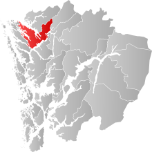
Lindås was a municipality in the north of Fylke Hordaland (which became part of Vestland in 2020 ) in western Norway . The administrative center of the municipality was Knarvik , a place in the southwest of the municipality. As part of the municipal reform in Norway , Lindås, Meland and Radøy were merged to form the new municipality of Alver on January 1, 2020 .
15,812 inhabitants lived in an area of 457.7 km² (as of January 1, 2019). Alversund , Isdalstø , Lindås, Ostereidet and Seim belonged to the municipality . The municipality number was 1263. The last mayor was Astrid Aarhus Byrknes ( KrF ).
geography
The municipality of Lindås was in the Nordhordland , north of the city of Bergen . Much of the municipality was on Lindåshalvøya. The municipality was bordered to the southeast by the Osterfjord . In the northeast, Lindås bordered the Fensfjord . The Lindås peninsula lies east of the Radfjord . The municipal area also included a small, southern part of the island of Radøy and the small island of Luro . The Lurefjord reached far into the commune. Due to the mountains, the east side of the municipality was only sparsely populated.
history
| year | population |
|---|---|
| 1951 | 4121 |
| 1960 | 4084 |
| 1970 | 7776 |
| 1980 | 10099 |
| 1990 | 11861 |
| 2000 | 12492 |
| 2010 | 14286 |
| 2017 | 15731 |
The area of the commune was first settled by Vikings, then English monks came to the region and lived with the Vikings. The Lindås parish established the parish on January 1, 1838. On March 1, 1879, the parish was split off from the new Masfjorden municipality . At that time 6,374 inhabitants lived in this area. On January 1, 1910, the Austrheim commune was split off. The population fell to 4,433. On January 1, 1964, the area of the municipality was enlarged again for the first time as part of the entire Norwegian territorial reform. The following areas were added:
- The farms Nipo, Dyrkelbotn and Eitrdalen (12 inhabitants)
- The area of the municipality of Hosanger , north of the Osterfjord (791 inhabitants)
- The area of the municipality of Hamre , north of the Osterfjord (1,240 inhabitants)
- The entire municipality of Alversund (2,099 inhabitants)
- The "Titland" area of Sæbø municipality, north of Seim (40 inhabitants)
At the same time, the municipality lost two areas: The island of Radøy with 305 inhabitants belonged to the new municipality Radøy from January 1, 1964, the areas Einestrand, Eihkebotn and Kikallen with 25 inhabitants belonged to the municipality of Modalen from this point on .
coat of arms
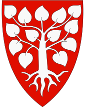
Description : A thirteen-leaved linden tree with roots in red.
politics
The municipal council had 31 seats. The 2015 election had the following result:
| Political party | Seats |
| Workers' part | 6th |
| Fremskrittspartiet | 5 |
| Høyre | 4th |
| Kristelig_Folkeparti | 9 |
| Senterpartiet | 4th |
| Sosialistisk_Venstreparti | 1 |
| Venstre | 1 |
Infrastructure
Europastraße 39 ran along the southern border of the municipality . It comes from the island Flatøy in the southwest and runs through the main town Knarvik . The road continues along the Osterfjord coast towards Hjelmås . There the Fv391 branches off to the north. The European route 39 continues on the fjord coast to Ostereidet . From there the Fv394 runs to Askeland. The E39 continues to the northeast. On its course the Fv570 branches off towards the north to Masfjorden.
From Knarvik, road 57 runs north, it runs across Lindåshalvøya to Hundvin, Lindås and the Mongstad industrial area . There is also a ferry connection north from Mongstad. Numerous other, smaller country roads continued to run across the municipality. There was no railway in the area of Lindås municipality.
tourism
There were eight parishes in Lindås municipality:
| local community | Surname | place | Construction year |
|---|---|---|---|
| Alversund | Alversund Church | Alversund | 1879 |
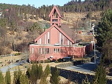
| Knarvik Church | Knarvik | 2014 | |
| Hundvin | Hundvin Church | Hundvin | 1936 |
| Lindås | Lindås Church | Lindås | 1865 |
| Lygra | Lygra Church | Luro | 1892 |
| Myking | Myking Church | Myking | 1861 |
| Easter Eid | Church of Easter Eid | Easter Eid | 1988 |
| Seim | Seim Church | Seim | 1878 |
| Vike | Vike Church | Vikanes | 1891 |
Individual evidence
- ↑ Navn på nye kommuner. February 19, 2019, accessed October 1, 2019 (Norwegian).
- ↑ Dag Jukvam: Historisk oversikt over endringer i kommune- og fylkesinndelingen ( Norwegian ) Statistisk sentralbyrå . 1999.
- ↑ Table: 04813: Members of the local councils, by party / electoral list at the Municipal Council election (M) ( Norwegian ) Statistics Norway. 2015.
Coordinates: 60 ° 37 ′ 29 ″ N , 5 ° 19 ′ 42 ″ E


