Easter Eid
| Easter Eid | ||||
|---|---|---|---|---|
|
||||
| Basic data | ||||
| Country | Norway | |||
| Province (fylke) | Vestland | |||
| Municipality (commune) : | Alver | |||
| Coordinates : | 60 ° 38 ′ N , 5 ° 29 ′ E | |||
| Residents : | 374 | |||
| Height : | 24 moh. | |||
Ostereidet is a place in the east of the municipality of Alver in Fylke Vestland . The place is on the north bank of the Osterfjord . The European route 39 leads through the north of Ostereidet. The Fv394 heads north to Askeland .
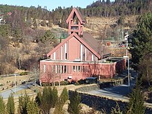
In Ostereidet there is a primary school, a church and a restaurant. The red concrete church was designed by the architect Bengt Suleng and inaugurated on December 18, 1988. It offers space for 350 people.
Individual evidence
- ↑ Ostereidet kyrkje . Kirkesøk: Kirkebyggdatabasen. Retrieved March 28, 2014.
- ↑ Oversikt over Nåværende Kirker ( Norwegian ) KirkeKonsulenten.no. Retrieved March 28, 2014.


