Tysnes
| coat of arms | map | |
|---|---|---|

|
|
|
| Basic data | ||
| Commune number : | 4616 | |
| Province (county) : | Vestland | |
| Administrative headquarters: | Uggdal | |
| Coordinates : | 60 ° 0 ′ N , 5 ° 35 ′ E | |
| Surface: | 255.12 km² | |
| Residents: | 2,869 (Feb 27, 2020) | |
| Population density : | 11 inhabitants per km² | |
| Language form : | Nynorsk | |
| Website: | ||
| politics | ||
| Mayor : | Kåre Martin Kleppe ( H ) (2015) | |
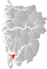
| Location in the province of Vestland | ||

|
||
Tysnes is an island municipality in the Norwegian Fylke Vestland . It consists of a group of islands south of Bergen where the Hardangerfjord meets the coast. Most of the municipality is on the island of Tysnesøy.
geography
The municipality borders Bjørnafjorden municipality in the north and Kvinnherad in the east . The municipalities of Stord and Fitjar are to the southwest and Austevoll to the west . The municipality belongs to the Sunnhordland region . The highest mountain in the municipality is called Tysnessåta ( 753 moh. ).
The administrative center is in Uggdal.
history
The old name of the municipality Njardarlog derives from Njörd ( bokmål : Njård , nynorsk Njord , Old Norse Njörðr ), the god of weather and seas in Norse mythology , and suggests that this was the religious center for larger parts of Vestlandet .
The Iron Age burial ground Årbakkavollen is located in the region .
Tysnes has been its own municipality since 1838.
Economy and Transport
Tysnes has ferry connections from Hodnanes to the south and west to Jektevik and Huglo in the Stord commune. The ferry goes north from Våge to Halhjem in Os municipality. A bridge in the east of the island of Tysnesøy ( Lukksund bru ) connects the municipality with Fusa on the mainland.
