Askful
| coat of arms | map | |
|---|---|---|

|
|
|
| Basic data | ||
| Commune number : | 4645 | |
| Province (county) : | Vestland | |
| Administrative headquarters: | Askful | |
| Coordinates : | 61 ° 24 ' N , 5 ° 15' E | |
| Surface: | 326.2 km² | |
| Residents: | 3,011 (Feb 27, 2020) | |
| Population density : | 9 inhabitants per km² | |
| Language form : | Nynorsk | |
| Website: | ||
| politics | ||
| Mayor : | Ole André Klausen ( H ) (2019) | |
| Location in the province of Vestland | ||

|
||
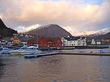
is amunicipalityinSunnfjordinVestlandProvince inNorway. It is located directly on theAtlantic. The municipality has an area of 326 km² and 3011 inhabitants (as of February 27, 2020). The municipality is administered from Askvoll. The highest point is the Bleia with a height of 1304 meters.
geography
Geographical location
Askvoll is located in the western Norwegian province of Vestland , which was formed on January 1, 2020 from the previous provinces of Sogn og Fjordane and Hordaland . Askvoll is in the former province of Sogn og Fjordane. The municipality extends over an area of 326 km² with a north-south extension of 24.7 km and an east-west extension of 52.7 km. In the west the Værlandet represent the border and in the east it is bounded by the municipality of Sunnfjord . In between there is a low mountain ridge rising partly steeply from the sea, the highest point of which is the summit of Blægja with 1304 moh. represents. In the south, the municipality is bounded by a long fjord, which is divided into Bue , Vilnes and Dalsfjorden . The Stav and Førdefjorden border in the north .
Municipal structure
The municipality Askvoll consists of numerous individual and scattered settlements and four larger settlements ( Tettstader ):
- Askvoll (main town)
- Holmedal
- Stongfjorden
- Herland (on Atløy )
Neighboring communities
Askvoll borders Sunnfjord to the east. With no direct land connections, Askvoll borders in the north in the Førdefjord with the municipality of Kinn and in the south with the municipality of Fjaler , whose land area is south of the Dalsfjord .
history
etymology
The name of the main town Askvoll and the resulting municipality name are derived from a farm of the same name ( Old Norse Askvǫllr ) because the church of today's town, Askvoll kyrkje , was built there. The word is made up of the syllable "ask" (German: ash ) and full (German: meadow ).
History of the commune
The municipality Askvoll was on 1 January 1838 as the formannskapsdistrikt founded. Originally the parish was identical to the parish Askvoll ( Prestegjeld ) with the sub-parishes Askvoll, Vilnes, Øn, and Hyllestad. In 1862 the two southernmost sub-parishes, Øn and Hyllestad (residents: 2475), were split off from Askvoll and combined with the sub-parish Bø from Lavik commune to form the new commune of Hyllestad . The population of Askvoll fell from around 5500 to 3065.
On January 1, 1888, several farms around the town of Hersvikbygda , in the northern part of the island of Sula , as well as farms on other, smaller islands with a total population of 317 people were dissolved by the municipality of Askvoll and added to the municipality of Utvær . On January 1, 1964, parts of the dissolved municipalities of Vevring (407 residents) and Bru (92 residents), which were located south of the Førdefjord, were incorporated into the municipality of Askvoll. As a result, the number of inhabitants rose to 3585. On January 1, 1990, Askvoll and Fjaler carried out a land swap : The towns of Vårdal, Holmedal , Rivedal and parts of Hestad (total population 731) came to Askvoll, in return the towns of Fure, Folkestad and Våge (total population 482 ) to Fjaler.
religion
The majority of Askvoll's residents belong to the Church of Norway . The responsible parish is Askvoll parish, which belongs to the Sunnfjord provost ( Bjørgvin diocese ) and has been identical to the boundaries of Askvoll municipality since January 1, 2006, after being merged with the parishes of Holmedal and Vilnes.
| Parish (Sokn) | Surname | place | Construction year |
|---|---|---|---|
| Askful | Askful kyrkje | Askful | 1863 |
| Bulandet Bedehuskapell | Musøya in Bulandet | 1905 | |
| Holmedal kyrkje | Holmedal | 1868 | |
| Kvammen Kapell | Combs | 1977 | |
| Stongfjorden Bedehuskapell | Stongfjorden | 1908 | |
| Vilnes kyrkje | Vilnes ( Atløy ) | 1674 | |
| Værlandet Bedehuskapell | Værlandet | 1960 |
politics
| Mayor of Askvoll since 1837 | |||
|---|---|---|---|
| Surname | Life dates | Political party | Term of office |
| Georg Prahl Harbitz | 1802-1889 | 1837-1839 | |
| Mads M. Askevold | 1839-1840 | ||
| Carl Johan Christie | 1842-1857 | ||
| Mons Andersen Askevold | 1858-1862 | ||
| Mads M. Askevold | 1863-1867 | ||
| Mathias V. Rødsæth | 1868-1871 | ||
| Jens O. Askevold | 1872-1873 | ||
| Kolbein S. Fisms | 1874-1879 | ||
| Ole S. Nordeide | 1880-1907 | ||
| Mathias K. Stubseid | 1864-1934 | V | 1908-1934 |
| Olai one | 1934-1942 | ||
| Harald Slåttelid | NS | 1942-1945 | |
| Olai one | 1945 | ||
| Sverre Ringstad | SP | 1946-1955 | |
| Mads Flokenes | V | 1956-1963 | |
| Magne Loftheim | 1964-1971 | ||
| Kåre Ness | * 1929 | SP | 1972-1987 |
| Jorunn Ringstad | * 1943 | SP | 1988-1992 |
| Kjellaug Veivåg Høyvik | * 1949 | SP | 1993-2003 |
| Aud Kari Stone Country | * 1950 | Ap | 2004-2011 |
| Frida Melvær | * 1971 | H | 2011-2019 |
| Ole André Klausen | * 1975 | H | since 2019 |
Municipal council
The municipal council consists of 21 members who are elected for four years and has been composed as follows since the 2019 municipal council election:
mayor
The mayor (ordførar) of a municipality in Norway is a representative of the strongest party in the local council, elected to lead the local parliament. Ole André Klausen, member of the Høgre, was elected mayor for the current term of office from 2019 to 2023 .
coat of arms
Blazon : "In green a pierced silver Byzantine cross ."
The motif is supposed to remind of the more than 1000 years old and almost four meter high stone cross from Korssund. Korssund used to belong to the Askvoll municipality, but in 1990 it was added to the Fjaler municipality . The coat of arms has been in use since January 5, 1990. The blazon reads (in Norwegian):
«På green botn i sølv ein utskrådd gjennombora kross (Korssundkrossen)»
"On a green ground in silver an exposed (with outwardly widening ends) pierced cross (Korssundkreuz)."
Culture and sights
Museums
- Veteranbåtlaget M / S Stangfjord - museum ship
- Bulandet Temapark - theme park specializing in the region's fishing and war history, as well as the coastal landscape and culture.
Buildings
- Ingolf Arnarson Statue - Oversized statue of Ingólfur Arnarson on a pedestal near the town of Rivedal on the Dalsfjord
- Geita lighthouse ( Norwegian : Geita fyr ) - lighthouse on the island of Geita , in operation since 1897
Natural monuments
The mountain Alden (also known as the "Norwegian horse"), which is located on the island of the same name , is a landmark of the municipality. It rises very steeply, sometimes rising almost vertically to 481 moh. from the sea and is visible around 100 km from the sea in clear weather.
Sports
There are numerous opportunities to do sports in the community. The well-developed network of trails is suitable for cycling , horse riding and hiking . Due to the numerous wrecks and the mostly very clear water near the coast and in the fjords, there are also very good conditions for scuba diving . Canoeing and fishing are also popular water sports .
Economy and Infrastructure
traffic
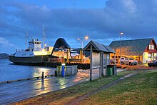
The municipality is located a few kilometers west of the E39 and can be reached from there via Fylkesvei 609 , which also runs in an extensive loop through a large part of the municipality. Several larger and smaller spur roads branch off from this main traffic route, including the Fylkesveien Fv608, Fv366, Fv363, Fv362 and Fv361. The municipality's two largest islands, Værlandet and Atløy, are connected to the main town of Askvoll by a regular ferry service. Another ferry line connects Askvoll with Furu, a place in the municipality of Fjaler .
Established businesses
- Helle Knivfabrikk (knife manufacturer), founded in 1932
- Bulandet Fiskeindustri (fish factory),
- Sigurd Løkeland Hermetikkfabrikk (manufacturer of canned shrimp )
education
There are four primary schools with a total of around 300 students in the municipality of Askvoll:
- Askful skule
- Atløy skule
- Bulandet skule
- Gjelsvik skule
With the exception of the Atløy skule (1st to 7th grade), students are taught from 1st to 10th grade in all schools. There is also a private Montessori school in Holmedal .
Sons and daughters of the commune
- Ingólfur Arnarson , discoverer
- Hans Arentz , district judge
- Anders Askevold , landscape painter
- Nikolaus Gjelsvik, lawyer
- Johannes Harbitz, seaman
- Jorunn Ringstad, politician
- Tore Storehaug (* 1992), politician
literature
- Kåre Flokenes, Bård Titlestad: Stadnamn i Askvoll. Erling Skjalgssonselskapet, 1999, ISBN 82-91640-08-4 .
- Arvid A. Follevåg: Askvoll - Kommunesenteret ved Sunnfjordleia. Askvoll so-called, 2006, ISBN 82-991605-9-6 .
- Abraham Loftheim, Svein Åge Knudsen: Askvoll bygdebok. Askvoll soemd, 1971, ISBN 82-90106-02-5 .
- Gaute Losnegård: Dalsfjordboka - from Gaularfjellet to Bulandet. Skald AS 1999, ISBN 82-7959-007-2 .
- Gaute Losnegård: Havfolk and fjordfolk - allmennsoge for Askvoll. Askvoll Kommune, 2009, ISBN 978-82-93016-00-7 .
- Gaute Losnegård: Havfolk og fjordfolk - allmennsoge for Askvoll B. 2. Askvoll municipality, 2011, ISBN 978-82-93016-01-4 .
Web links
Individual evidence
- ↑ Statistisk sentralbyrå - Befolkning
- ↑ a b Topographic map of Norway (excerpt with Askvoll) , ut.no, accessed on February 16, 2015.
- ↑ Askvoll , nrk.no, accessed on February 16, 2015 (Norwegian)
- ↑ Store norske leksikon : Askvoll , accessed on February 16, 2015 (Norwegian)
- ↑ a b Dag Jukvam: Historisk oversikt over endringer i commune and fylkesinndelingen. (PDF) Statistics Norway, 1999, accessed February 16, 2015 (Norwegian).
- ↑ Ordførarar i Askvoll frå 1837 , nrk.no, accessed on February 16, 2015 (Norwegian).
- ↑ a b Ordførar i Askvoll. Askvoll Kommune, accessed March 19, 2020 (Norwegian).
- ↑ Civic heraldry of Norway - Norske Kommunevåpen. Heraldry of the World, accessed February 16, 2015 (Norwegian).
- ↑ “Korsundkrossen” - communevåpenet. Askvoll Kommune, October 17, 2019, accessed on March 19, 2020 (Norwegian).
- ↑ Bulandet Temapark. Visit Fjordkysten, accessed March 19, 2020 .
- ↑ Ingolf Arnarson, Rivedal , fjordkysten.no, accessed on February 16, 2015 (German)
- ↑ a b c d Askvoll , gonorway.com, accessed on February 16, 2015 (English)
- ↑ Alden Wanderwege , fjordkysten.no, accessed on February 16, 2015 (German)
- ↑ Grunnskule i Askvoll. Askvoll Kommune, accessed March 19, 2020 (Norwegian).
- ↑ Om skulen. Holmedal Montessoriskule, accessed March 19, 2020 (Norwegian).


