
Sogndal
| coat of arms | map | ||
|---|---|---|---|

|
|
||
| Basic data | |||
| Commune number : | 4640 | ||
| Province (county) : | Vestland | ||
| Administrative headquarters: | Leikanger | ||
| Coordinates : | 61 ° 14 ' N , 7 ° 3' E | ||
| Surface: | 1,257.89 km² | ||
| Residents: | 11,847 (Feb 27, 2020) | ||
| Population density : | 9 inhabitants per km² | ||
| Language form : | Nynorsk | ||
| Postal code : | 6850 | ||
| Structure: | Kaupanger , Fjærland , Sogndalsfjøra , Balestrand , Hermansverk | ||
| Website: | |||
| politics | |||
| Mayor : | Arnstein Menes ( Sp ) (2019) | ||
| Location in the province of Vestland | |||

|
|||

Sogndal is a Norwegian municipality in Fylke Vestland .
On January 1, 2020, the municipalities of Balestrand (excluding the village of Nesse) and Leikanger were integrated into Sogndal as part of the municipal reform. This increased the community from 852.71 km² to 1472.82 km², of which 1257.89 km² are land and 214.93 km² are water.
history
The grave of an 8 to 12 year old girl from the 5th century with grave goods was found.
On June 15, 1184, King Sverre Sigurdsson and King Magnus Erlingsson fought for supremacy near Slinde in the Battle of Fimreite . King Magnus and many followers fell. A building stone in Nornes near Sogndal commemorates this battle.
In 1917 a farmer found the Eggja stone . It is an inscribed tombstone that is dated around the year 700.
Localities
Like practically all Norwegian municipalities, it consists of several localities and many other settlements, not all of which are inhabited all year round.
The largest and best-known towns are Sogndalsfjøra , Kaupanger , Fjærland , Balestrand and Hermansverk , which are also the location of at least one church.
Attractions
- Stave Church in Kaupanger , built around 1200
- “De Heibergske Samlinger”, local history and boat museum
- "Norsk Bremuseum", glacier museum
- “Den norske bokbyen”, book town in Fjærland
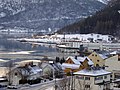
Sogndal
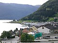
Sogndal
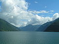
Fjærlandsfjord
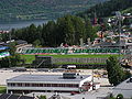
Stadium in Sogndal


traffic
For a long time, parts of the community were only accessible by sea. The Frudals tunnel on main road no. 5 was only opened in 1994. Today this road connects the three largest towns in the municipality and is also an important north-south connection. In Sogndal the main road No. 55 crosses No. 5.
The place Sogndal is considered a transport hub and is served by several express bus routes. There are also some regional bus routes for local distribution.
Express boats operate on the Sogndalsfjorden and Lærdalsfjorden. There is also the ferry connection on main road 5 between Mannheller and Fodnes, and the Kaupanger-Gudvangen tourist ferry, which only operates in summer.
South of Sogndal and Storehaugfjellet is the Sogndal Airport , this is served on regular services to small commercial aircraft.
Web links
Individual evidence
- ↑ Statistisk sentralbyrå - Befolkning
- ↑ Arealstatistikk for Norge on www.kartverket.no, accessed on January 13, 2020
Alver | Askful | Askøy | Aurland | Austevoll | Austrheim | Mountains | Bjørnafjorden | Bremanger | Bømlo | Eidfjord | Etne | Fedje | Fitjar | Fjaler | Glopping | Gulen | Hyllestad | Høyanger | Chin | Kvam | Kvinnherad | Chandelier | Lærdal | Masfjorden | Modals | Osterøy | Samnanger | Sogndal | Solund | City | Stord | Stryn | Sunnfjord | Sveio | Tysnes | Ullensvang | Ulvik | Vaksdal | Vik | Voss | Øygarden | Årdal