Bremanger
| coat of arms | map | |
|---|---|---|

|
|
|
| Basic data | ||
| Commune number : | 4648 | |
| Province (county) : | Vestland | |
| Administrative headquarters: | Svelgen | |
| Coordinates : | 61 ° 50 ′ N , 4 ° 59 ′ E | |
| Surface: | 833.1 km² | |
| Residents: | 3,629 (Feb 27, 2020) | |
| Population density : | 4 inhabitants per km² | |
| Language form : | Nynorsk | |
| Website: | ||
| politics | ||
| Mayor : | Anne Kristin Førde ( Ap ) (2019) | |
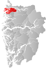
| Location in the province of Vestland | ||

|
||
Bremanger is a municipality in the province of Vestland in Norway , located on Frøysjøen on the south side of the mouth of the Nordfjord . It borders Gloppen in the east and Kinn in the south . Beyond the Nordfjord and its estuary, Fåfjord, lie the northern part of Kinn and Stad .
The largest towns in the municipality are Svelgen (1,224 inhabitants; 1.11 km²) and Kalvåg (352 inhabitants; 0.41 km²). The smaller, but eponymous town of Bremanger (366 inhabitants; 0.65 km²; as of January 1, 2011) is located on the island of Bremangerlandet . The administration is in Svelgen. In addition, there are a large number of smaller settlements and farms, such as Elde .
The highest point is the 1670 m high Blånibba. A good four fifths of the municipal area belong to the mainland. The rest of the land area is formed by several islands in the mouth of the fjord, including Bremangerlandet as the largest. The eastern end of this island, the steep slope of the Hornelen mountain (860 m), is considered the highest sea cliff in Europe.
Sons and daughters of the commune
- Nikolai Astrup , Norwegian painter
Individual evidence
- ↑ Statistisk sentralbyrå - Befolkning
- ↑ Statistisk sentralbyrå, Statistics Norway: Urban settlements. Population and area, by municipality. 1 January 2012
- ↑ Fjellnamnet Hornelen Fylkesarkivet Sogn og Fjordane, accessed on June 17, 2020 (Norwegian)
