Hyllestad
| coat of arms | map | |
|---|---|---|

|
|
|
| Basic data | ||
| Commune number : | 4637 | |
| Province (county) : | Vestland | |
| Administrative headquarters: | Hyllestad | |
| Coordinates : | 61 ° 10 ′ N , 5 ° 20 ′ E | |
| Surface: | 258.9 km² | |
| Residents: | 1,328 (Feb 27, 2020) | |
| Population density : | 5 inhabitants per km² | |
| Language form : | Nynorsk | |
| Website: | ||
| politics | ||
| Mayor : | Kjell Eide ( Ap ) (2019) | |
| Location in the province of Vestland | ||

|
||
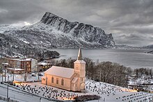
Hyllestad is a town and municipality in Fylke Vestland, Norway . It is located in the west of the Ytre Sogn landscape on the outer Sognefjord .
geography
The municipality surrounds the central fjord arm Åfjorden and borders Fjaler to the north and east and Høyanger to the south-east . South of the Sognefjord is Gulen while the island municipality of Solund is adjacent to the west. The highest peaks in the municipality are the characteristic mountains Risnesnipa , which belong to the Lifjell (or Lihesten ) mountain range, with a height of 776.5 meters, and Gygrekjeften with 710 meters, which are also an important landmark . The Hyllestad coastline is 106 km long.
population
Hyllestad is sparsely populated and has no Tettsteder (localities). The administrative center is located in the town of the same name, Hyllestad , where the school (1st – 10th grade), the kindergarten and a supermarket are also located. In addition, Leirvik is the second population center in the southeast of the municipality. There are scattered farms in the valleys between the two settlements and on the north side of Åfjord. The islands and peninsulas of the municipality are now uninhabited. The population has been falling since the post-war period.
traffic
Fylkesveg 57 (country road) connects the municipality with Dale i Sunnfjord in the north, in the south there is a ferry connection from Rysjedalsvika over the Sognefjord to Rutledal, from where you can reach Bergen by car. Rysjedalsvika also has fast boats on the Bergen - Sogn - Nordfjord line and a ferry to Krakhella on Solund.
In an easterly direction, the Rv. 607 the municipality with Lavik in the neighboring municipality of Høyanger, where it meets the E39 .
economy
The main source of income for the population has traditionally been agriculture, especially the keeping of sheep and cattle. Havyard Leirvik AS shipyard is the largest employer today.
Attractions
The Kvernsteinspark can be found in the village of Hyllestad, which has been teaching tourists the history of the millstones found there since 2002. These have been produced there since the Viking Age, and Hyllestad was one of the most important production facilities for these stones in the Middle Ages, which were shipped to Denmark, Sweden and continental Europe.
Another popular destination is the Lihesten mountain (714 m), which is a striking feature of the municipality's coastal landscape due to its steep slopes that slope down to the sea.
Individual evidence
- ↑ Statistisk sentralbyrå - Befolkning
- ↑ Høyeste Fjelltopp i hver kommune Norges Kartverk, accessed on June 10, 2020 (Norwegian)
- ↑ Befolkning , Statistisk sentralbyrå, accessed June 10, 2020 (Norwegian)
- ↑ Hyllestad - Store norske leksikon. Retrieved June 8, 2015 .
- ↑ http://www.kvernstein.no/hyllestad
Web links
- Hyllestad on Norgeskart


