Lærdal
| coat of arms | map | |
|---|---|---|

|
|
|
| Basic data | ||
| Commune number : | 4642 | |
| Province (county) : | Vestland | |
| Administrative headquarters: | Lærdalsøyri | |
| Coordinates : | 61 ° 6 ′ N , 7 ° 29 ′ E | |
| Surface: | 1,342.53 km² | |
| Residents: | 2,126 (Feb 27, 2020) | |
| Population density : | 2 inhabitants per km² | |
| Language form : | Nynorsk | |
| Postal code : | 6887 | |
| Website: | ||
| politics | ||
| Mayor : | Jan Geir Solheim ( Sp ) (2011) | |
| Location in the province of Vestland | ||

|
||

Lærdal is a Norwegian municipality in the province of Vestland . It is located on the southern bank of the Sognefjord in the Indre Sogn region and has around 2,200 inhabitants. The municipality's administrative headquarters are in Lærdalsøyri .
local community
Name and coat of arms
The name of the municipality is derived from the Old Norse word Læradalr , which is probably derived from the name of the river Lærr . The old Norse word dalr means " valley ".
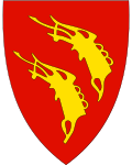
The municipality's coat of arms shows two yellow, stylized dragon heads on a red background. The motif is taken from the roof decoration of the Borgund stave church . This coat of arms has been approved since 1987.
Tusenårssted
Tusenårssted the municipality is Gamleøyri , the oldest part of the place Lærdalsøyri. 161 wooden buildings represent typical architectural styles of the 18th and 19th centuries. In 1971 Gamleøyri was listed as a historical monument . According to the Riksantikvaren, it is an important urban ensemble, on par with cities like Røros , Bergen or Gamle Stavanger . On the night of January 19, 2014, Lærdalsøyri was hit by a serious fire in which 40 houses burned down. In the Gamleøyri area, the Synneva Eris hus was destroyed along with two other houses .
Neighboring communities
Lærdal borders in the north with the municipality of Sogndal and Årdal . To the east are the municipalities of Vang in the province of Innlandet and Hemsedal in the province of Viken . In the south there are the municipalities of Ål and Hol , which also belong to the province of Viken. In the southwest is Aurland and in the west Vik .
Boundary changes
In 1860 Årdal municipality and in 1864 Borgund were spun off from Lærdal. 100 years later, Borgund and a small part of the municipality of Årdal on the Årdalsfjord were rejoined to the municipality. The area around Frønningen has belonged to Lærdal since 1992. It was spun off from the municipality of Leikanger .
places
- Borgund
- Frønningen
- Ljøsne
- Lærdalsøyri (administrative headquarters)
- Maristova
- Steinklepp
- Tønjum
traffic
The Bergen Royal Road ( Den Bergenske Kongevei ), which was built in the 18th century and ran from Bergen via Oslo, Sweden and Finland to St. Petersburg, ran through Lærdal . Remnants of the road are preserved on the Lærdalselva east of Lærdalsøyri.
Lærdal is named for the longest road tunnel in the world, the Lærdalstunnel , which connects Lærdalsøyri and Aurlandsvangen .
Culture and sights
Lærdal is home to one of Norway's most beautiful stave churches, Borgund Stave Church .
The wild salmon museum Norsk Villakssenter is located in Lærdal . The river Lærdalselva is known as a good salmon river.
Web links
- Norsk villakssenter Wild Salmon Information Center
- Sogn art center art center
Individual evidence
- ↑ Statistisk sentralbyrå - Befolkning
- ↑ a b c Geir Thorsnæs, Svein Askheim: Lærdal. In: store norske leksikon. January 23, 2014, accessed December 15, 2014 (Norwegian).
- ↑ Lærdalsøyri. In: store norske leksikon. Retrieved December 15, 2014 (Norwegian).
- ↑ Brannen på Lærdalsøyri. Riksantikvaren, January 2014, accessed December 15, 2014 (Norwegian).
- ↑ Eirik Helleve: Lærdal kommune, Sogn og Fjordane. In: allkunne.no. October 9, 2014, accessed December 15, 2014 (Nynorsk in Norwegian).


