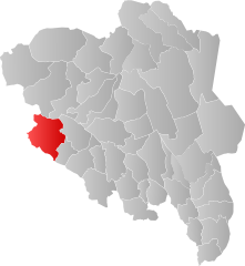
Vang
| coat of arms | map | |
|---|---|---|

|
|
|
| Basic data | ||
| Commune number : | 3454 | |
| Province (county) : | Domestic | |
| Administrative headquarters: | Vang i Valdres | |
| Coordinates : | 61 ° 12 ′ N , 8 ° 29 ′ E | |
| Height : | 1370 moh. | |
| Surface: | 1,505.45 km² | |
| Residents: | 1,578 (Feb 27, 2020) | |
| Population density : | 1 inhabitant per km² | |
| Language form : | Nynorsk | |
| Website: | ||
| politics | ||
| Mayor : | Vidar Eltun ( Ap ) (2011) | |
| Located in the province of Innlandet | ||

|
||
The municipality of Vang in Norway has an area of 1,505 km² with a north-south extension of 56 km and an east-west extension of 47.3 km (including water 47.6 km). With a population of 1578 (as of February 27, 2020) the population density is 1.05 inhabitants per square kilometer.
The municipality is located in the west of the Fylke Innlandet and is administered by the place Grindaheim.
The highest point is the Kalvehøgdi with a height of 2,208 meters. Three quarters of the landscape protrudes over the nine hundred meter limit.
The coat of arms shows three swords pointing upwards.
Attractions
Area attractions include the Øye stave church , which Høre stave church , the St. Thomas Church on the Filefiell and waterfalls Ryfossen and Sputrefossen.
The wooden stave church Vang was dismantled in 1841 to enable a larger new building, and in 1842 near Karpacz (Karpacz) in the Giant Mountains rebuilt. Today's church of Vang and the Vang stone , a rune stone whose ornamentation is eponymous for the early medieval Vang style, is located at the former location .
Personalities
- Ole Edvard Antonsen (* 1962), trumpeter
- Claus Bendeke (1763–1828), lawyer, civil servant and inspector of Greenland
- Christopher Andreas Holmboe (1796–1882), philologist, orientalist and numismatist
- Andreas Molbech Lund (1749–1820), civil servant and inspector of Greenland
Web links
- Statistics Vang. Retrieved November 25, 2007 .

