Øyer
| coat of arms | map | |
|---|---|---|

|
|
|
| Basic data | ||
| Commune number : | 3440 | |
| Province (county) : | Domestic | |
| Administrative headquarters: | Tingberg | |
| Coordinates : | 61 ° 18 ′ N , 10 ° 30 ′ E | |
| Height : | 916 moh. | |
| Surface: | 639.92 km² | |
| Residents: | 5,100 (Feb 27, 2020) | |
| Population density : | 8 inhabitants per km² | |
| Language form : | neutral | |
| Website: | ||
| traffic | ||
| Railway connection: | Dovrebanen | |
| politics | ||
| Mayor : | Brit Kramprud Lundgård ( Ap ) (2015) | |
| Located in the province of Innlandet | ||

|
||
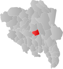
The municipality of Øyer in Norway has an area of 640 km² with a north-south extension of 31.7 km and an east-west extension of 36 km.
Established on January 1, 1838 as the Formannskaps district, the municipality is one of the few in Norway whose borders have remained unchanged since then.
Øyer has 5100 inhabitants (as of February 27, 2020). The municipality is located in Fylke Innlandet in central Gudbrandsdal north of Lillehammer and is administered from Tingberg.
Personalities
- Ole Stenen (1903–1975), skier
- Frost (* 1973), drummer, member of the band Satyricon
Web links
Commons : Øyer - collection of images, videos and audio files
- Statistics Øyer . Retrieved November 25, 2007.
