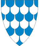
Øystre Slidre
| coat of arms | map | |
|---|---|---|

|
|
|
| Basic data | ||
| Commune number : | 3453 | |
| Province (county) : | Domestic | |
| Administrative headquarters: | Heggenes | |
| Coordinates : | 61 ° 15 ' N , 9 ° 3' E | |
| Height : | 1080 moh. | |
| Surface: | 963.1 km² | |
| Residents: | 3,229 (Feb 27, 2020) | |
| Population density : | 3 inhabitants per km² | |
| Language form : | Nynorsk | |
| Website: | ||
| politics | ||
| Mayor : | Odd Erik Holden ( Sp ) (2019) | |
| Located in the province of Innlandet | ||

|
||
The municipality of Øystre Slidre in Norway has an area of 963 km² with a north-south extension of 45.1 km and an east-west extension of 39.8 km.
Øystre Slidre has 3229 inhabitants (as of February 27, 2020).
The municipality is located in Fylke Innlandet and is administered by the place Heggenes / Tingvang.
The coat of arms represents slate as a symbol for the slate industry.
geography
The highest point is the Øystre Rasletind with a height of 2,010 meters.
73 percent of the landscape rises over 900 meters. 60 km² consists of water and 25 percent of the landscape consists of forest. The lowest point in the landscape is at an altitude of 410 meters.
The largest lakes are Vinstri , Yddin, Vangsjøen, Javnin and Olevatn.
Attractions
One of the sights is the Hegge stave church .
Beitostølen , one of the most famous winter sports resorts in Norway, is also in the municipality .
Web links
Individual evidence

