Sør-Fron
| coat of arms | map | |
|---|---|---|

|
|
|
| Basic data | ||
| Commune number : | 3438 | |
| Province (county) : | Domestic | |
| Administrative headquarters: | Hundorp | |
| Coordinates : | 61 ° 37 ' N , 9 ° 49' E | |
| Height : | 780 moh. | |
| Surface: | 742.21 km² | |
| Residents: | 3,119 (Feb 27, 2020) | |
| Population density : | 4 inhabitants per km² | |
| Language form : | neutral | |
| Website: | ||
| politics | ||
| Mayor : | Ole Tvete Muriteigen ( Sp ) (2011) | |
| Located in the province of Innlandet | ||

|
||
The municipality of Sør-Fron in Norway has an area of 742 km² with a north-south extension of 69 km and an east-west extension of 52.4 km (with water 53.3 km). With a population of 3119 (as of February 27, 2020) the population density is 4.2 inhabitants per square kilometer. The municipality is located in the Fylke Innlandet in the upper Gudbrandsdal and is administered by Hundorp. The highest point is the Blåkollen with a height of 1,580 meters.

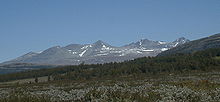
The Rondane National Park touches the territory of the municipality
history
Web links
Commons : Sør-Fron - collection of images, videos and audio files
- Statistics Sør-Fron. Retrieved November 25, 2007 .
Individual evidence
