North Aurdal
| coat of arms | map | |
|---|---|---|

|
|
|
| Basic data | ||
| Commune number : | 3451 | |
| Province (county) : | Domestic | |
| Administrative headquarters: | Fagernes | |
| Coordinates : | 61 ° 0 ′ N , 9 ° 21 ′ E | |
| Height : | 990 moh. | |
| Surface: | 906.48 km² | |
| Residents: | 6,413 (Feb 27, 2020) | |
| Population density : | 7 inhabitants per km² | |
| Language form : | neutral | |
| Website: | ||
| politics | ||
| Mayor : | Knut Arne Fjelltun ( Sp ) (2019) | |
| Located in the province of Innlandet | ||

|
||
The municipality of Nord-Aurdal in Norway has an area of 906 km² with a north-south extension of 52.4 km and an east-west extension of 43.3 km. Nord-Aurdal has 6413 inhabitants (as of February 27, 2020). The municipality is located in the west of the Fylke Innlandet and is administered by the place Fagernes. The larger settlements of the municipality are Aurdal, Fagernes and Leira. Aurdal used to be the administrative center of the municipality.
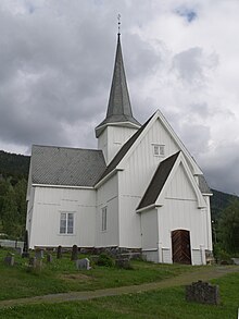
The highest point in North Aurdal is the Duptjernkampen with its 1,325 meters. Northern Aurdal's coat of arms shows the snow gentian . Sights include the Valdres Folk Museum in Fagernes and the Aurdal Fjell Church near Danebu. More than 50 percent of the landscape of North Aurdal is above an altitude of 900 meters. Big lakes are the Tisleifjorden, Strandefjorden and Aurdalsfjorden.
Web links
- Statistics North Aurdal. Retrieved November 25, 2007 .


