Ringebu
| coat of arms | map | |
|---|---|---|

|
|
|
| Basic data | ||
| Commune number : | 3439 | |
| Province (county) : | Domestic | |
| Administrative headquarters: | Ringebu | |
| Coordinates : | 61 ° 33 ' N , 10 ° 15' E | |
| Height : | 920 moh. | |
| Surface: | 1,247.58 km² | |
| Residents: | 4,392 (Feb 27, 2020) | |
| Population density : | 4 inhabitants per km² | |
| Language form : | neutral | |
| Website: | ||
| traffic | ||
| Railway connection: | Dovrebanen | |
| politics | ||
| Mayor : | Arne Fossmo ( Ap ) (2015) | |
| Located in the province of Innlandet | ||

|
||
is amunicipalityinFylke InnlandetinNorway.
The municipality is located in central Gudbrandsdalen . The highest point is the Storfjellet with a height of 1415 m. Larger settlements are Ringebu (administrative center) and Fåvang.
Attractions
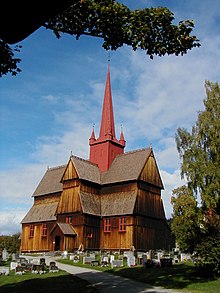
Ringebu Stave Church
see main article Ringebu Stave Church
The stave church in Ringebu ( Ringebu Stavkyrkje ) is one of the 28 still existing stave churches in Norway. The church continues to be used for congregational worship.
Sports
At the 1994 Winter Olympics in Lillehammer , the Super G competitions were held in Ringebu . The specially built facilities and slopes were extended to the Kvitfjell ski area after 1994 .
Personalities
- Lars Mytting (* 1968), editor, journalist and author
See also
Web links
Commons : Ringebu - collection of images, videos and audio files
- Statistics Ringebu. Retrieved November 25, 2007 .

