Alvdal
| coat of arms | map | |
|---|---|---|

|
|
|
| Basic data | ||
| Commune number : | 3428 | |
| Province (county) : | Domestic | |
| Administrative headquarters: | Steien | |
| Coordinates : | 62 ° 4 ′ N , 10 ° 30 ′ E | |
| Surface: | 942.15 km² | |
| Residents: | 2,432 (Feb 27, 2020) | |
| Population density : | 3 inhabitants per km² | |
| Language form : | neutral | |
| Website: | ||
| traffic | ||
| Railway connection: | Rørosbanen | |
| politics | ||
| Mayor : | Mona Murud ( Sp ) (2019) | |
| Located in the province of Innlandet | ||

|
||
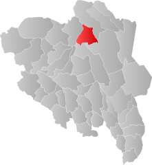
Alvdal is a Norwegian municipality in the Østerdalen region , at the foot of Tronfjell .
It borders on the municipality of Tynset to the north, Rendalen to the east, Stor-Elvdal to the south and Folldal to the west .
The mountain region around Alvdal is called "Alvdalsfjellene" and the area west of Alvdal is called "Alvdal Vestfjell". The highest point in Vestfjell is Stor Sølnkletten at 1827 m. In the western parts there are other peaks that exceed 1700 m. Alvdal Vestfjell has its own tribe of wild reindeer . The climate is comparable to the Rondane National Park .
The Rørosbane railway line crosses the municipality.
Alvdal's most famous son is the humorist Kjell Aukrust .
In Alvdal there is a production facility of the Synnøve Finde ASA dairy with around 150 employees.
Web links
- Alvdal on snl.no in the store norske leksikon (Norwegian)
- Official website of the Aukrust Museum
- Official website of the Synnøve Find ASA dairy

