Kvam
| coat of arms | map | |
|---|---|---|

|
|
|
| Basic data | ||
| Commune number : | 4622 | |
| Province (county) : | Vestland | |
| Administrative headquarters: | Norheimsund | |
| Coordinates : | 60 ° 25 ' N , 6 ° 9' E | |
| Height : | 1 - 1336 moh. | |
| Surface: | 616.93 km² | |
| Residents: | 8,457 (Feb 27, 2020) | |
| Population density : | 14 inhabitants per km² | |
| Language form : | Nynorsk | |
| Website: | ||
| politics | ||
| Mayor : | Torgeir Næss ( Ap ) (2019) | |
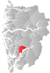
| Location in the province of Vestland | ||

|
||
Kvam Herad is a Herad municipality in the Norwegian Fylke Vestland . It borders in the north on the municipalities of Vaksdal and Voss , in the south on the municipality Kvinnherad and in the west on the municipalities Bjørnafjorden and Samnanger . In the east lies the Hardangerfjord and on its east side the municipality of Ullensvang . The larger towns in the municipality are Norheimsund, Øystese and Ålvik. The community center is Norheimsund . There are also many small villages in the municipality, including Steinstø . The highest point of the municipality is the Fuglafjell ( 1336 moh. ).
The Battle of Kvam took place on April 25-26, 1940 in the village of Kvam between British, Norwegian and German forces. The Germans moved north up the river valley to conquer central Norway.
coat of arms
Description : In blue, a silver post curved on both sides .
Personalities
- Geir Botnen (* 1959), pianist
- Jon Fosse (born 1959), author
- Valgerd Svarstad Haugland (* 1956), politician
- Trond Helleland (* 1962), Norwegian politician
- Oskar Øksnes (1921–1999), politician
- Geirr Tveitt (1908–1981), composer
- Yngve Sundvor , director

