
Kfar Shmaryahu: Difference between revisions
No edit summary |
|||
| Line 1: | Line 1: | ||
{{Infobox settlement |
{{Infobox settlement |
||
| name = Kfar Shmaryahu |
| name = Kfar Shmaryahu |
||
| native_name = {{Hlist |
| native_name = {{Hlist |
||
| {{Lang|he|{{Script/Hebrew|כְּפַר |
| {{Lang|he|{{Script/Hebrew|כְּפַר שְׁמַרְיָהוּ}}|rtl=yes}} |
||
| {{Lang|ar|كفار شمرياهو|rtl=yes}} |
| {{Lang|ar|كفار شمرياهو|rtl=yes}} |
||
}} |
}} |
||
| settlement_type = [[Local council (Israel)|Local council]] |
| settlement_type = [[Local council (Israel)|Local council]] |
||
| translit_lang1 = Hebrew |
| translit_lang1 = Hebrew |
||
| translit_lang1_type1 = [[ISO 259]] |
| translit_lang1_type1 = [[ISO 259]] |
||
| translit_lang1_info1 = Kpar Šmaryahu |
| translit_lang1_info1 = Kpar Šmaryahu |
||
| image_skyline = Kfarshmarjahu024.jpg |
| image_skyline = Kfarshmarjahu024.jpg |
||
| pushpin_map_alt = |
| pushpin_map_alt = |
||
| pushpin_map = Israel#Israel center ta |
| pushpin_map = Israel#Israel center ta |
||
| pushpin_mapsize = 250 |
| pushpin_mapsize = 250 |
||
| pushpin_label_position = right |
| pushpin_label_position = right |
||
| pushpin_map_caption = |
| pushpin_map_caption = |
||
| coordinates = {{coord|32|11|6|N|34|49|12|E|region:IL|format=dms|display=inline,title}} |
| coordinates = {{coord|32|11|6|N|34|49|12|E|region:IL|format=dms|display=inline,title}} |
||
| subdivision_type1 = |
| subdivision_type1 = |
||
| subdivision_name1 = |
| subdivision_name1 = |
||
| subdivision_type2 = [[Districts of Israel|District]] |
| subdivision_type2 = [[Districts of Israel|District]] |
||
| subdivision_name2 = |
| subdivision_name2 = {{flag|Tel Aviv District|name=Tel Aviv}} |
||
| established_title = Founded |
|||
{{flag|Tel Aviv District|name=Tel Aviv}} |
|||
| |
| established_date = 1937 |
||
| leader_title = Head of Municipality |
|||
| established_date = 1937 |
|||
| |
| leader_name = Serge Korchia |
||
| |
| unit_pref = dunam |
||
| |
| area_total_dunam = {{formatnum:2570|R}} |
||
| |
| population_footnotes = {{Israel populations|reference}} |
||
| |
| population_total = {{Israel populations|Kefar Shemaryahu}} |
||
| |
| population_as_of = {{Israel populations|Year}} |
||
| ⚫ | |||
| population_as_of = {{Israel populations|Year}} |
|||
| ⚫ | |||
}} |
}} |
||
[[File:Location kfarshmaryahu.png|thumb|right|upright|Location of Kfar Shmaryahu in the [[Tel Aviv District]]]] |
[[File:Location kfarshmaryahu.png|thumb|right|upright|Location of Kfar Shmaryahu in the [[Tel Aviv District]]]] |
||
'''Kfar Shmaryahu''' ({{lang-he|כְּפַר |
'''Kfar Shmaryahu''' ({{lang-he|כְּפַר שְׁמַרְיָהוּ}}, {{lang-ar|كفار شمرياهو}}) is a [[local council (Israel)|local council]] in [[Israel]], within the [[Tel Aviv District]]. |
||
==History== |
==History== |
||
Revision as of 17:57, 24 March 2021
Kfar Shmaryahu
| |
|---|---|
| Hebrew transcription(s) | |
| • ISO 259 | Kpar Šmaryahu |
 | |
 Kfar Shmaryahu  Kfar Shmaryahu | |
| Coordinates: 32°11′6″N 34°49′12″E / 32.18500°N 34.82000°E | |
| District | |
| Founded | 1937 |
| Government | |
| • Head of Municipality | Serge Korchia |
| Area | |
| • Total | 2,570 dunams (2.57 km2 or 640 acres) |
| Population (2022)[1] | |
| • Total | 1,951 |
| • Density | 760/km2 (2,000/sq mi) |

Kfar Shmaryahu (Hebrew: כְּפַר שְׁמַרְיָהוּ, Arabic: كفار شمرياهو) is a local council in Israel, within the Tel Aviv District.
History
Kfar Shmaryahu was founded in May 1937, during the Fifth Aliyah.[2] The founding members were German-Jewish immigrants, who named the village after Shmaryahu Levin (1867–1935), a Russian-born Jewish Zionist leader. The village was founded as an agricultural community, with forty farms, thirty auxiliary farms, and twenty lots for housing projects. A well was drilled, and a synagogue that became the center of community life was also built. In late 1938, 60 families were living there, and the predominant language was German. Throughout the following years the town absorbed new immigrants. In 1950 it was declared a local council and was granted additional land.[3]
-
 Kfar Shmaryhu 1938
 -
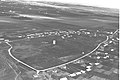
 Kfar Shmaryahu in December 1937
 -
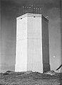 Kfar Shmaryahu water tower 1940
 -
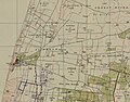 Kfar Shmaryahu 1942 1:20,000
 -
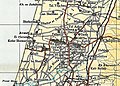 Kfar Shmaryhu 1945 1:250,000


Status
Kfar Shmaryahu is an affluent suburb of Tel Aviv. It is ranked very highly on the Israeli socio-economic scale (10 out of 10).[4] According to Yedioth Ahronoth, Kfar Shmaryahu's municipality annually spends NIS 8,700 per resident, a figure higher than Tel Aviv and over twice as high as Jerusalem.[5]
In 2022 it had a population of 1,951.[1]
Notable residents
- Shai Agassi
- Shulamit Aloni (1928–2014), civil-rights politician and left-wing activist
- Aki Avni
- Ilanit
- Daphni Leef, activist and video editor
- Ari Shavit, author, journalist
- Miriam Siderenski, Olympic runner
- Stef Wertheimer
- Sapir Koffmann, Miss Israel 1984
References
- ^ a b "Regional Statistics". Israel Central Bureau of Statistics. Retrieved 21 March 2024.
- ^ "Village history". kfar-shemaryahu.muni.il (in Hebrew). Retrieved 2006-11-24.
- ^ http://www.welcomehome.co.il/en/kfar-shmaryahu-3/
- ^ "The Richest Towns: Savyon, Kfar Shmaryahu, Omer - Haaretz - Israel News Haaretz.com". www.haaretz.com. Retrieved 2016-09-10.
- ^ "Investing in You". Yedioth Ahronoth - Mamon. 2008-02-12. p. 1.
External links
- Official website of Kfar Shmaryahu (in Hebrew)
| Cities |  | |
|---|---|---|
| Local councils | ||
| ||
This geography of Israel article is a stub. You can help Wikipedia by expanding it. |