
Gorges du Guiers Mort: Difference between revisions
Content deleted Content added
No edit summary Tag: Disambiguation links added |
|||
| Line 4: | Line 4: | ||
<gallery mode=packed heights="180px"> |
<gallery mode=packed heights="180px"> |
||
(Barcelona) A |
(Barcelona) A Bridge over a mountain Stream - Gorges du Guiers Mort, Chartreuse - 1802 - William Turner - Tate Britain.jpg| ''A Brige over a mountain Stream - Gorges du Guiers Mort, Chartreuse'' - 1802- [[William Turner]] - [[Tate Britain]] |
||
</gallery> |
</gallery> |
||
{{coord|45.3519|5.7595|display=title}} |
{{coord|45.3519|5.7595|display=title}} |
||
Revision as of 07:22, 31 October 2022

The Gorges du Guiers Mort is a canyon located in the French department of Isère, downstream of Saint-Pierre-de-Chartreuse. The river Guiers Mort flows through it.
-
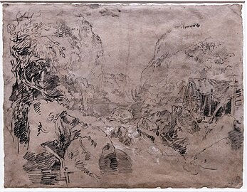 A Brige over a mountain Stream - Gorges du Guiers Mort, Chartreuse - 1802- William Turner - Tate Britain
_A_Bridge_over_a_mountain_Stream_-_Gorges_du_Guiers_Mort,_Chartreuse_-_1802_-_William_Turner_-_Tate_Britain.jpg)
_A_Brige_over_a_mountain_Stream_-_Gorges_du_Guiers_Mort,_Chartreuse_-_1802_-_William_Turner_-_Tate_Britain.jpg)
45°21′07″N 5°45′34″E / 45.3519°N 5.7595°E
This article related to geography of France is a stub. You can help Wikipedia by expanding it. |