
Henderson County, Tennessee: Difference between revisions
County template |
m Interwiki: Adding: sv:Henderson County, Tennessee |
||
| Line 76: | Line 76: | ||
[[nds:Henderson County (Tennessee)]] |
[[nds:Henderson County (Tennessee)]] |
||
[[pt:Condado de Henderson (Tennessee)]] |
[[pt:Condado de Henderson (Tennessee)]] |
||
[[sv:Henderson County, Tennessee]] |
|||
[[zh:亨德森縣 (田納西州)]] |
[[zh:亨德森縣 (田納西州)]] |
||
Revision as of 15:03, 16 May 2008
Henderson County | |
|---|---|
 Location within the U.S. state of Tennessee | |
 Tennessee's location within the U.S. | |
| Coordinates: 35°39′N 88°23′W / 35.65°N 88.39°W | |
| Country | |
| State | |
| Seat | Lexington |
| Largest city | Lexington |
| Area | |
| • Total | 526 sq mi (1,362 km2) |
| • Land | 520 sq mi (1,347 km2) |
| • Water | 6 sq mi (15 km2) 1.12% |
| Population (2000) | |
| • Total | 25,522 |
| • Density | 49/sq mi (19/km2) |
| Time zone | UTC−6 (Central) |
| • Summer (DST) | UTC−5 (CDT) |
Henderson County is a county located in the U.S. state of Tennessee. As of 2000, the population was 25,522. The 2005 Census Estimate placed the population at 26,425 [1]. Its county seat is LexingtonTemplate:GR.
(Note that neither Hendersonville, Tennessee nor Henderson, Tennessee is in Henderson County, although the latter is in nearby Chester County.)
Geography
According to the U.S. Census Bureau, the county has a total area of 526 square miles (1,362 km²), of which, 520 square miles (1,347 km²) of it is land and 6 square miles (15 km²) of it (1.12%) is water.
Parks and Recreation
Adjacent counties
- Carroll County (north)
- Decatur County (east)
- Hardin County (southeast)
- Chester County (southwest)
- Madison County (west)
Demographics

As of the censusTemplate:GR of 2000, there were 25,522 people, 10,306 households, and 7,451 families residing in the county. The population density was 49 people per square mile (19/km²). There were 11,446 housing units at an average density of 22 per square mile (8/km²). The racial makeup of the county was 90.45% White, 8.00% Black or African American, 0.13% Native American, 0.14% Asian, 0.01% Pacific Islander, 0.33% from other races, and 0.94% from two or more races. 0.97% of the population were Hispanic or Latino of any race.
There were 10,306 households out of which 32.30% had children under the age of 18 living with them, 56.90% were married couples living together, 11.70% had a female householder with no husband present, and 27.70% were non-families. 24.90% of all households were made up of individuals and 10.70% had someone living alone who was 65 years of age or older. The average household size was 2.44 and the average family size was 2.90.
In the county, the population was spread out with 24.30% under the age of 18, 8.70% from 18 to 24, 28.80% from 25 to 44, 23.90% from 45 to 64, and 14.20% who were 65 years of age or older. The median age was 37 years. For every 100 females there were 92.90 males. For every 100 females age 18 and over, there were 90.00 males.
The median income for a household in the county was $32,057, and the median income for a family was $38,475. Males had a median income of $28,598 versus $21,791 for females. The per capita income for the county was $17,019. About 9.20% of families and 12.40% of the population were below the poverty line, including 14.60% of those under age 18 and 14.50% of those age 65 or over.
Cities and towns
References
External links
Municipalities and communities of Henderson County, Tennessee, United States | ||
|---|---|---|
| Cities | 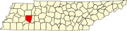 | |
| Towns | ||
| CDPs | ||
| Other communities | ||
| Footnotes | ‡This populated place also has portions in an adjacent county or counties | |