
Kurnell, New South Wales: Difference between revisions
Adam.J.W.C. (talk | contribs) |
Adam.J.W.C. (talk | contribs) |
||
| Line 87: | Line 87: | ||
Triathlons are held in Kurnell annually. There are running tracks through Botany Bay National Park, as well as running along the beach and swimming in the netted area of Silver Beach. |
Triathlons are held in Kurnell annually. There are running tracks through Botany Bay National Park, as well as running along the beach and swimming in the netted area of Silver Beach. |
||
Four wheel Drive . |
|||
Four wheel Drive access can be gained into [[Boat Harbour (Kurnell)|Boat Harbour Beach]] via Captain Cook Drive. |
|||
[[Boat Harbour (Kurnell)|Boat Harbour Beach]] is the location of a [[4WD]] park. Access can be gained via Captain Cook Drive. People are permitted to drive on the beach with their 4WD’S. An entry fee is required and one may drive along the beach for at least two kilometres. |
|||
This location also offers fishing, sailing and windsurfing activities. There is a free shuttle bus service during whale watching season, departing from the parking area of the office of the National Park. |
This location also offers fishing, sailing and windsurfing activities. There is a free shuttle bus service during whale watching season, departing from the parking area of the office of the National Park. |
||
Revision as of 02:40, 13 October 2008
| Kurnell Sydney, New South Wales | |||||||||||||||
|---|---|---|---|---|---|---|---|---|---|---|---|---|---|---|---|
 | |||||||||||||||
| Population | 2,110 (2006 Census) | ||||||||||||||
| Postcode(s) | 2231 | ||||||||||||||
| Location | 22 km (14 mi) south of CBD | ||||||||||||||
| LGA(s) | Sutherland Shire | ||||||||||||||
| State electorate(s) | Cronulla | ||||||||||||||
| Federal division(s) | Cook | ||||||||||||||
| |||||||||||||||

Kurnell is a suburb in southern Sydney, in the state of New South Wales, Australia. Kurnell is located 22 kilometres south of the Sydney central business district, in the local government area of the Sutherland Shire.
Location
The Kurnell Peninsula is the southern headland of Botany Bay. Cronulla and Woolooware are the only adjacent suburbs. It is a 10–12 minute drive from the centre of Cronulla. La Perouse is located opposite, on the northern headland of Botany Bay.
The eastern side of the peninsula is part of Botany Bay National Park, with sheer sandstone cliffs dominating the coastline. Silver Beach provides protected swimming in Botany Bay, with views towards the city. Towra Point Nature Reserve is located on the western side of the suburb.
-
 sandstone cliffs at Kurnell
 -
 sandstone cliffs at Kurnell


History
There are two theories for the origin of the name Kurnell. It is either a deviation of an Aboriginal word "collonel" or a deviation of the name of an early settler, John Connell.
The original inhabitants on the Kurnell Peninsula were the Gweagal people or tribe of peoples. They belonged to a clan of the Tharawal (or Dharawal) tribe of Indigenous Australians. They were the traditional custodians of the southern geographic areas of Sydney.
Kurnell is considered to be ‘the birthplace of modern Australia’, as it is the place where Captain James Cook landed on 29 April 1770, when navigating his way around Australia on his ship, the Endeavour. [1] The landing place is located on the north-eastern part of the national park. Sutherland Point is named in honour of a crew member, Scotsman Forby Sutherland, who died of tuberculosis during their eight days here and was buried on the shore. Cape Solander is named after Swedish botanist Daniel Solander, a colleague of Joseph Banks. Inscription Point was named by the Australian Philosophical Society in 1822 when they secured a plaque to the cliff face to mark the point of the Endeavour’s crew first landing.
Dampier Street, Tasman Street and Torres Street commemorate other navigators in Australia’s history.
The first land grant of 700 acres (2.8 km2) was made in 1815, to Captain James Birnie, who established Alpha Farm. 'Alpha' is the first letter in the Greek alphabet and the name was thought appropriate for the first farm in the area. In 1821 John Connell Junior was also granted land here and used it for timber getting. His father purchased Alpha Farm from Birnie and by 1842 the Connell family's estate was over one thousand acres (4 km²) in size. In 1860, Alpha Farm was sold to Thomas Holt (1811-88), who owned most of the land that stretched from Sutherland to Cronulla. The area was known as Birniemere for a time and Holtmere was once a locality.
Before the 1920s, Kurnell was used by fisherman as schools of several varieties of fish inhabited the Botany Bay foreshore and the open sea. Fishermen built numerous huts and shacks which sheltered them for the weekend fishing. During the Great Depression, from the late 1920s, many severely affected low-income families took up residence there. The area was known as Happy Valley.[2]

Places of interest
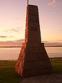
The northern part of the peninsula is a historic site known as Captain Cook’s Landing Place with a number of memorials located here:
- the Captain Cook Memorial Obelisk
- the Sir Joseph Banks Memorial
- the Solander Monument
- the Sutherland Monument
The Discovery Centre provides information and displays relics from the early days in Kurnell’s history. Endeavour Heights is a recreation area in the Botany Bay National Park. The Kurnell Lookout provides brilliant views of Botany Bay and the northern headland of Botany Bay at La Perouse.
Cape Solander is popular amongst whale watchers during the migration season.
-
 Captain Cook Memorial Obelisk
 -
 Cook's Landing Place monument
 -
 Cook's Landing Place plaque
 -
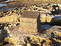
 Cook's Tree plaque


-
 Sir Joseph Banks Memorial
 -
 Sutherland's monument
 -
 Solander's monument
 -
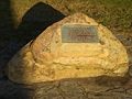
 Cook's Well plaque


Commercial areas
The small residential area with a population of 2600 (as at 30/06/07 source ssec.org.au) is located to the north with a small group of shops in the village of Kurnell. Kurnell is dominated by an industrial area, which includes the Caltex Oil Refinery. Refined petrol is piped to the other side of Botany Bay in an underwater pipeline. The Kurnell Desalination Plant, currently under construction, is expected to provide much of southern Sydney with an alternative water supply. It has been criticised on environmental grounds (greenhouse gases and impact of large amounts of deoxygenated brine), and was shelved, but was resumed after the March 2007 N.S.W. state elections. Continued widespread protest by residential, environmental, and community groups was declared to be irrelevant. Immediate work began on a pipeline under Botany Bay to carry desalinated water to northern suburbs and the size of the desalination plant was doubled.(source, smh.com.au-search. Desalination). Total water stored in the Sydney catchment was at a low of 36.9% on 7 June 2007 but rainfall increased volume stored to 64% as of 7 Feb 2008. [3]The water supply of Kurnell is supplemented with bore water.
Sand mining on the peninsula has depleted the area of much of the sand that was originally there. It has been said that 40 metre deep pools now form in the dunes [4].Pools are clearly visible in view from Google Earth. The remaining sand dune is used as a recreational off-road area for 4 wheel drives. The Cronulla sand dunes formed part of the location for the films Forty Thousand Horsemen, directed by Charles Chauvel in 1940 and Mad Max Beyond Thunderdome. Sand dunes are currently being replaced with domestic and industrial waste. The only road to Kurnell Peninsula is also flanked by a sewerage treatment plant. [5]
Sport and recreation
Triathlons are held in Kurnell annually. There are running tracks through Botany Bay National Park, as well as running along the beach and swimming in the netted area of Silver Beach.
Four wheel Drive .
Boat Harbour Beach is the location of a 4WD park. Access can be gained via Captain Cook Drive. People are permitted to drive on the beach with their 4WD’S. An entry fee is required and one may drive along the beach for at least two kilometres.
This location also offers fishing, sailing and windsurfing activities. There is a free shuttle bus service during whale watching season, departing from the parking area of the office of the National Park.
References
- ^ http://www.kurnell.com/home.htm Kurnell
- ^ http://www.ssec.org.au/our_environment/our_bioregion/kurnell/history/index.htm Kurnell, a pictorial history
- ^ Water storage and supply reports - Sydney Catchment Authority
- ^ The Kurnell Peninsula - Sand Dunes
- ^ Kurnell Sand Dunes - 18/09/2003 - QWN - NSW Parliament