Fannaråki: Difference between revisions
Content deleted Content added
rm unneeded flaficon using AWB |
TheGrappler (talk | contribs) m Adding category Category:Luster, Norway (using HotCat) |
||
| Line 35: | Line 35: | ||
[[Category:Mountains of Sogn og Fjordane]] |
[[Category:Mountains of Sogn og Fjordane]] |
||
[[Category:Jotunheimen]] |
[[Category:Jotunheimen]] |
||
[[Category:Luster, Norway]] |
|||
Revision as of 11:35, 15 June 2010
| Fannaråki | |
|---|---|
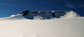
 Fannaråki seen from Fannaråkbreen (glacier) at the mountains northern base. Summit to the right. | |
| Highest point | |
| Elevation | 2,068 m (6,785 ft) |
| Prominence | 450 m (1,480 ft) |
| Coordinates | 61°31′N 7°55′E / 61.517°N 7.917°E |
| Geography | |
| Location | Luster, Sogn og Fjordane, Norway |
| Parent range | Hurrungane |
| Topo map | 1518 III Sygnefjell |
Fannaråki or Fannaråken is a mountain in Luster, Sogn og Fjordane, Norway. It measures 2,068 metres.
The name
The first element is derived from fonn f 'glacier made of snow', the last element is the finite form of råk f 'mountain ridge'.
Guidebooks
- A. Dyer et al. "Walks and Scrambles in Norway", ISBN 1-904466-25-7.
- Bernhard Pollmann "Norway South", ISBN 3763348077.
- James Baxter "Scandinavian Mountains and Peaks Over 2000 Metres in the Hurrungane", ISBN 0955049709.
External links
