Bom Jardim de Minas: Difference between revisions
m infobox syntax |
No edit summary |
||
| Line 6: | Line 6: | ||
|website = [http://www.camarabomjardimdeminas.com.br/ Bom Jardim de Minas, Minas Gerais] |
|website = [http://www.camarabomjardimdeminas.com.br/ Bom Jardim de Minas, Minas Gerais] |
||
|nickname = BJM |
|nickname = BJM |
||
|motto = ''Omnis |
|motto = ''Omnis gloriam Dei'' |
||
|image_skyline = Bomjardim.jpg |
|image_skyline = Bomjardim.jpg |
||
|imagesize = 250px |
|imagesize = 250px |
||
Revision as of 13:59, 20 December 2012
Bom Jardim de Minas | |
|---|---|
Municipality | |
| The Municipality of Bom Jardim de Minas | |
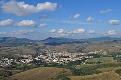
 View of Bom Jardim de Minas of Guido de Paula Museum | |
| Nickname: BJM | |
| Motto: Omnis gloriam Dei | |
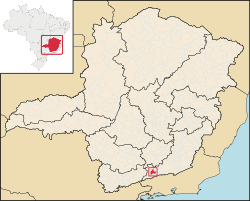
 Location in Brazil | |
| Country | Brazil |
| Region | Southeast |
| State | Minas Gerais |
| Incorporated | December 17, 1937 |
| Government | |
| • Mayor | Joaquim Laercio Rodrigues, PMDB |
| Area | |
| • Total | 401 km2 (241.2 sq mi) |
| Elevation | 1,119 m (3,671 ft) |
| Population (2010)[1] | |
| • Total | 6,511 |
| • Density | 15/km2 (10/sq mi) |
| Time zone | UTC-3 (UTC-3) |
| • Summer (DST) | UTC-2 (UTC-2) |
| Postal Code | 37310-000 |
| Area code | +55 32 |
| Website | Bom Jardim de Minas, Minas Gerais |
Bom Jardim de Minas is a city of the state of Minas Gerais, Brazil.
The name means Good Gardens of Minas.
It is situated in the southern part of Minas Gerais and in the middle of the Mantiqueira Hills, at 1,200 meters high, which gives the city a mild climate.
The only paved road that reaches Bom Jardim de Minas is the BR-267, which connects the city to the southern part of the State of Minas Gerais and the region of Juiz de Fora.
Population: 6,500 inhabitants.
It was founded in 1770 with the formation of a farm land in current city. When it came near the farm houses, became a parish and then the district with the installation of the chapel on May 2, 1856. And finally, in 1938, the district was upgrade to city, with two districts, headquarters and Taboão.
Currently, the city has been increasing in the festivities such as Carnival, which is considered by many the best in the region; Country Party with the Agricultural Exhibition in May, feast in honror to Jesus Christ in August, as well as the natural attractions waterfalls, mountains, falls to the practice of sports, investing in city tourism.
History
The farm was named "Fazenda Bom Jardim," the origin of the town name, due to a beautiful and well maintained garden that was in front of the farm, garden with flowers of this variety and exquisite beauty. Near this small farm houses began to emerge and thus formed the parish's "Good Garden", because this time the Portuguese were also coming to explore gold in the Rio Grande.
When Manoel Arriaga and his compatrício, Antonio Correa de Lacerda, seeing the development of the Parish of Bom Jardim de Minas, decided to make a small chapel in the yard of the Good Farm Garden, where they practiced prayers, rosaries and novenas. When you finish the chapel in 1770 (date printed on the altar of the old matrix). Antonio Correa de Lacerda asked his partner to place as patron of the parish "Good Jesus of Matozinhos" because this was already devoted Holy because there inherited from his father, João Marques Batista, who brought Portugal a small picture of Bom Jesus of Matozinhos. Arriaga's request promptly answered compatrício thus was introduced in the chapel. This was the first image of "Lord Jesus Christ" venerated for many years in the small chapel in the yard of Finance Bom Jardim de Minas.
Then they sent sculpting in 1781, the official image, which is that we worship today in the Catholic Church. According to an official historian and restorer of São João del Rei, it was carved from red cedar, covered with sheepskin and mass emassado with top quality. The artist who carved erred in doing so, made with four nails. The correct in all images of the Crucified Christ is with three nails: A right hand, a left hand and a foot, overlapping the other.
His eyes are made of marcasite, one looking to the earth and the sky to another.
According to the book "The Dream" authored by John the Baptist Junior Marques, page 201 to 202 describes: "The image of the Lord Jesus, exalted and revered patron of the Good Mother Garden for the first time through the streets of the parish, assisted in solemn procession, accompanied by a large crowd of faithful d'never before seen on April 21, 1873, a day of dazzling festival celebrated in honor of the Glorious Patron, in times past, 83 years after, it was not customary to leave Picture his throne. Both did not exist in the Matrix, or given that there had been a litter suitable for the image, and since then serving vai was made on this occasion by Belizário Ribeiro de Carvalho ".
The first image of the Lord Jesus, was brought from Portugal by Sir Joao Batista Marques. She is Baroque, the cross has the gold finish on its base, and at its ends has four flushes, two right and two on the left, is also in its gold finish. This precious picture now belongs to Mrs. Adelia Aredes Lacerda, who is the granddaughter of John Marques Junior, who was great-grandson of Antonio Correa de Lacerda, a founder of Bom Jardim.
The central part of the chapel was enlarged in 1800, at the elevation of the Bom Jardim Parish seat.
On February 12, 1892, Antonio Correa de Lacerda and his wife D. Ana D'Souza Guard donated all his assets in land to the Church of Bom Jesus do Matosinhos. Antonio Correa de Lacerda died in 1903, after eleven years of giving.
The tower of the old church was built in 1925 as chief mason, Joaquim dos Santos (Joaquim estocador), Jose Pena and Haughty Ramalho.
As detailed, the cemetery is located beside the Mother Church (Chapel Steps Today) is a characteristic of the time and was intended to awaken reflection on death and bolster their mother as faithful.
Auguste de Saint-Hilaire says in his book "Journey through the region of the Rio Grande", chapter 5, page 57, arriving near the Camp of the Good Garden, in 1819, stated: "Amid the naked hills and deserts that appeared before my eyes as I left the forest, came across the Chapel of Garden of Good Turvo, built on the hill, a little broke the monotony of the landscape. "
Geography
The area of the municipality is 412 km ², representing 0.07% of the state, the region 0.045% and 0.005% of the entire Brazilian territory. Located on the banks of the Rio Grande in the southern region of the state of Minas Gerais, and the Serra da Mantiqueira.
It is located 281 km from Belo Horizonte, the state capital. The relief of the municipality consists of plateaus, with an average altitude of 1,100 meters, however, this average decreases toward the Rio Grande, to form the lowland rain that is circumvented by the "sea of hills and mountains," with higher topographic level. The culmination is the altitude of 1733 meters, the Serra da Bandeira, in Taboão.
The region consists of many Taboão high altitude mountains with many water springs, which means that there are several waterfalls in the region. The headwaters of the Rio do Peixe, one of the largest rivers in the region, located in the hills district Taboão.
Climate
The city has mesothermal highland tropical climate, with cold and dry winter rains and higher, taking into account the situation of latitude and altitude ranging from 990m to 1733m. According to regional averages, the winter is hardly unpleasant unless one or the other day, the coldest month, July, has averaged approximately 55 ° F and 61 ° F, daily maximum of 71 ° F and 73 ° F and minimum of 41 ° F to 50 ° F and may reach even with minimum absolute in Celsius Scale up to 0 ° C (32 ºC), and may even gear.
Mayors of Bom Jardim de Minas
This list composes all the mayors of the city of Bom Jardim de Minas, with their respective years since the birth of the city in 1938.
- 1. Americo Ferreira Pena - 1939 to 1946
- 2. Joaquim A. Souza Correia - 1946 to 1948
- 3. Assis Rodrigues da Silva - 1948 to 1951
- 4. Geraldo Andrade - 1951 to 1955
- 5. José Landim (1st term) - 1955 to 1959
- 6. Octaviano Nardy Ribeiro (1st term) - 1959 to 1963
- 7. José Landim (2nd term) - 1963 to 1967
- 8. Altomare Orlando de Carvalho - 1967 to 1971
- 9. Bougleux José de Andrade - 1971 to 1972
- 10. Itacy Bougleux de Andrade - 1972 to 1973
- 11. Dimas Abbud - 1973 to 1977
- 12. Octaviano Nardy Ribeiro (2nd term) - 1977 to 1982
- 13. Sebastiao Delgado de Almeida - 1983 to 1988
- 14. Manoel Rodrigues - 1989 to 1992
- 15. Valtencir de Paula Nunes (1st term) - 1993 to 1996
- 16. Genivaldo Marques de Paula - 1997 to 2000
- 17. Valtencir de Paula Nunes (2nd term) - 2001 to 2004
- 18. Carlos Roberto Marques - 2005 to 2008
- 19. Joaquim Laercio Rodrigues (1st term) - 2009 to 2012
- 20. Joaquim Laercio Rodrigues (2nd term) - 2013 - current
21°57′S 44°11′W / 21.950°S 44.183°W
References
- ^ "Estimativas das Populações Residentes, em 01.07.2006, Segundo os Municípios" (PDF) (in in Portuguese). IBGE. Retrieved 2006-09-01.
{{cite web}}: CS1 maint: unrecognized language (link)


