
Kilmaurs Place
Kilmaurs Place or The Place, is an old mansion house at grid reference NS41234112 in Kilmaurs, East Ayrshire, Scotland. The house stands on a prominence above the Carmel Water and has a commanding view of the surrounding area.

The History of Kilmaurs Place.
Introduction
The building seen today (2008) replaced the ane ancient, strong building, belonging to the Earl of Glencairne, environed with a fair parke, called Carmell wod, from the watter of Carmell that runs by it. The Place was begun by the 9th Earl of Glencairn, William Cunninghame, Lord Chancellor of Scotland. A most extensive and imposing building was intended, however financial problems and his unexpected death resulted the abandonment of the original design; today's structure represents the remnants of the unfinished mansion.[1]

The ediface is said by the Royal Commission, following McNaught,[2] to be a 17th-century mansion abutting the East wall of its predecessor (NS44SW 16), contradicting the view that it is an incomplete structure, the building work having ceased upon the death of the 9th Earl of Glencairn.[3]
| Etymology |
| Carmel, the oldest form of which is Caremuall, is thought to be derived, according to McNaught[4], from the Gaelic 'Car' meaning a 'fort', and 'Meall'. meaning a hill. Therefore, 'The fort on the hill'. |
Adamson in 1875 calls the building 'My Lord's Place' and goes on to say that With the exception of the mansion-house which is in an excellent state of preservation, blocks of masonry adjacent to it are much decayed, and at first sight seem the remains of a large building that Time has shattered and almost leveled to the ground. But this is not the case. The seeming ruins are nothing more than the remnant of the walls of an elegant structure which was in the course of erection during the lifetime of the Lord Chancellor of Scotland, William, ninth Earl of Glencairn.[5]
The remainder of the Barony of Kilmaurs, together with 'The Place' was purchased by Alexander, 9th Earl of Eglinton circa 1720.[6] The term Kilmaurs House was also used for it at this time. It was occupied at one time by a dowager Countess of Eglinton and in 1793 Captain Ralston, of Warwickhill resided in The Place.[7][8]
The Monk's or Mack's Well water runs into the Carmel beneath Kilmaurs Place. It is said that many years ago the laird tried to prevent the local people from using the well. It dried up until the lord changed his mind, but has run continuously ever since.[4]
Morton Park, part of the old estate, was gifted to the people of Kilmaurs by the Morton family of Lochgreen in 1921 and the official opening was 9 September 1922[9].
Kilmaurs as the Clan Cunninghame seat
Sir William Cunningham of Kilmaurs, married Margaret Denniston of Glencairn & Finlaystone in the late 14th-century and from this time Kilmaurs became increasing less significant as a family seat, Finlaystone being the prefered home. Sir William's grandson, Alexander Cunningham, was created Ist Earl of Glencairn on 28th May 1488.[10] The Cunninghame chiefs seem to have only a slight connection with the barony of Kilmaurs after 1484 when Finlaystone appears to have become the family seat.
William Cunninghame of Kilmaurs (1631 - 1664), 9th Earl of Glencairn


William Cunninghame was at first a loyal supporter of Charles I and for this reason he was forced to forfeit his title to the Scottish Parliament; but in time he realized the possibility of Scotland being drawn into the feud between Charles and his Parliament in London, upon which his support for this absolute monarch quickly diminished. William's title was restored and following the execution of Charles I, he fought with the Highland clans against General Monck when Oliver Cromwell invaded Scotland.
Following a personal duel and skirmishes in the ranks he withdrew his forces. He thereafter fought Monk's columns at Dumbarton where overwhelming odds forced him to surrender on honorable terms. He returned home but was thrown into prison on suspicion of plotting, being mistrusted by Archbishop Sharp. Following the Restoration, Charles II rewarded him with the appointment of Privy Councilor. A few years later he was elevated to Lord Chancellor, during which time he started to enlarge Kilmaurs Place. Further political intrigues reduced his power and standing greatly and he died a disillusioned man.[11]
Kilmaurs Place described

The word 'Place' in Scots refers to a landed proprietor's mansion house,[12] however in academic and practical terms it is a larger building which surrounds a central courtyard. This suggests that Kilmaurs Place was to have been a larger structure with a central courtyard. The term 'Palace' only acquired its present connotations at a later date.[13]

The structure consists of a main block lying roughly East-West, with a stair-wing projecting in the centre of the West wall with crow step gabling. It has two storys and an attic, with 'modern buildings' forming the former farm outbuildings. In 1956 Kilmaurs Place is described as having been restored, and in use as a farmhouse.[14] Kilmaurs Place was listed on 14/04/1971 as a Category B historic building.[15]
Davis records that the house has a 'T' plan and is dated circa 1620. The 'ruins' appear to be the uncompleted lower floor of a 16th-century range. The Place itself is not vaulted, although the 'ruins' have a slate roofed vaulted chamber still in use by the present occupants. A fine 16th-century fireplace and carved jambs are located in the The Place itself. The original entrance was at the staircase projection, the door still being visible in the fabric of the building and an armorial panel above is still visible. The windows have been much altered as have the floor levels within the building.[16] Campbell comments on the possibility of Kilmaurs Place being built upon an older castle which is no longer evident.[17]
In 1912 the remains of an avenue opening on the Townend and leading circuitously to the old frontage could still be discerned in the field adjoining the main road. The entrance off the Mill Vennel by a bridge over the Carmel Water, is said to have been formed when the frontage was changed.[18]
Kilmaurs Place gallery 2008
-

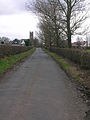
The Driveway leading to Kilmaurs Place. -
The Mill Vennel looking southwards towards St.Maurs-Glencairn kirk. -
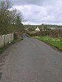
The Mill Vennel looking northwards towards the Carmel Brig. -

The 'ruins' and the vaulted chamber facing the park. -

The 'ruins' facing the War Memorial. -
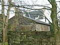
The vaulted chamber building with the 17th century house in the background. -

Kilmaurs Place facing the park.


Kilmaurs castle and fortalice

Adamson relates in 1875 that the ancient castle was in the vicinity of Jock's or Jack's Thorn farm, and indeed several old people from Kilmaurs in 1875 remembered playing amongst the ruined remnants of masonry which occupied the site of this old castle of the Cunninghames.[19] Metal detectorists have found medieval coins in this area amongst old unhewn building or foundation stones.
Dobie in 1874 that the old baronial residence was about a mile South-East of Kilmaurs and ruins could still be pointed out on the farm of Jock's-Thorn. He goes on to say that this could have been the Villam de Cunninghame, the original residence and first possession of this ancient family.[20] Lambroughton is another possible site.
Davis records that the local farmer has noted that pottery and stones are brought up by ploughing at an elevated spot (NS 417 411) off the old entrance to Jocks-Thorn farm at a point East of both Tour and Jocks-Thorn.[21]
McNaught records that a charter of 1498 refers to the Castle and Fortalice of the Braony and lands of Kilmaweris (sic). The explanation for the Kilmaurs Place / Jocks Thorn locations of Kilmaurs Castle is that the prime location for a castle was on the eminence now occupied by Kilmaurs Place and this was the baronial residence, whilst Jocks Thorn was a separate defensive structure, a fortalice, usually more a place for the protection of the people than a residence for the laird.[22] Stewarton shows this situation with Corsehill Castle as the manorial residence and the Templehouse fortalice as the place for the protection of the people.[23]
Kilmaurs mill

Every barony had a thirled mill owned by the laird which the farmers had to use, and the nearby Kilmaurs Mill on the Carmel Water dated back to at least the early 1600s and may have been the one directly associated with the laird at the The Place. An unusual feature of this old mill, now demolished, was a carved stone showing a millstone drive spider or rind (often used on Miller's tombstones as a symbol of the milling trade) on which the upper grindstone rested, a ring of rope, a bill for dressing millstones, and a grain shovel.
The Barony of Kilmaurs
The Barony of Kilmaurs was composed of the lands of Buston (now Buiston), Fleuris (now Floors), Lambroughton, Whyrrig, now Wheatrig and previously Quhytrige[24], and Southwick or Southuck (now South Hook). South Hook (previously also Southeuck or Seurnbenck) is near Knockentiber and was part of the tenement of Lambroughton within the barony.
1912 Gallery
-
![An uncompleted section of the 'The Place'.[4]](//upload.wikimedia.org/wikipedia/commons/thumb/1/12/Kilmaurs_place_foundations.jpg/120px-Kilmaurs_place_foundations.jpg)
An uncompleted section of the 'The Place'.[4] -
![Internal details.[4]](//upload.wikimedia.org/wikipedia/commons/thumb/8/8e/Kilmaurs_place_interior_details.jpg/120px-Kilmaurs_place_interior_details.jpg)
Internal details.[4] -
!['The Place' from the south, looking towards St. Maurs - Glencairn church.[4]](//upload.wikimedia.org/wikipedia/commons/thumb/0/05/Kilmaurs_place_from_the_Kilmaurs_kirk_side.jpg/120px-Kilmaurs_place_from_the_Kilmaurs_kirk_side.jpg)
'The Place' from the south, looking towards St. Maurs - Glencairn church.[4] -
!['The Place' from the park.[4]](//upload.wikimedia.org/wikipedia/commons/thumb/2/2c/Kilmaurs_place_from_the_park.jpg/120px-Kilmaurs_place_from_the_park.jpg)
'The Place' from the park.[4] -
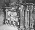
The Glencairn Aisle in Saint Maurs-Glencairn kirk & the memorial to James, 7th Earl of Glencairn who died in 1597. -
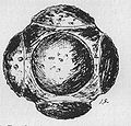
This Carved Stone Balls Petrosphere was found at Jock's Thorn farm.
![An uncompleted section of the 'The Place'.[4]](/wiki/File:Kilmaurs_place_foundations.jpg)
![Internal details.[4]](/wiki/File:Kilmaurs_place_interior_details.jpg)
!['The Place' from the south, looking towards St. Maurs - Glencairn church.[4]](/wiki/File:Kilmaurs_place_from_the_Kilmaurs_kirk_side.jpg)
!['The Place' from the park.[4]](/wiki/File:Kilmaurs_place_from_the_park.jpg)


References
- ^ Harvey, William (1910), Picturesque Ayrshire. Pub. Valentine & Sons, Dundee, etc. P. 80.
- ^ McNaught, Duncan (1912). Kilmaurs Parish and Burgh. Pub. A. Gardner, Paisley. P. 103.
- ^ McNaught, Duncan (1912). Kilmaurs Parish and Burgh. Pub. A. Gardner, Paisley. P. 93
- ^ a b c d e f *McNaught, Duncan (1912). Kilmaurs Parish and Burgh. Pub. A.Gardner. Cite error: The named reference "McNaught" was defined multiple times with different content (see the help page).
- ^ Adamson, Archibald R. (1875), Rambles Round Kilmarnock. Pub. T. Stevenson, Kilmarnock. P. 167 - 168.
- ^ Dunlop, A. I. et al. Edit. (1959) Ayrshire at the time of Burns. Ayr Arch & Nat Hist Soc. P. 301.
- ^ Dobie, James (1876), Cuninghame Topographized by Timothy Pont. Pub. John Tweed, Glasgow. P. 289.
- ^ McNaught, Duncan (1912). Kilmaurs Parish and Burgh. Pub. A. Gardner, Paisley. P. 105
- ^ Lucky, Paul (2007). Oral communication to Griffith, Roger S.Ll.
- ^ Finlaystone castle
- ^ The History of the Earls of Glencairn
- ^ Warrack, Alexander (1982). Chambers Scots Dictionary. Pub. W. & R. Chambers. Edinburgh.
- ^ McKean, Charles (2001). The Scottish Chateau. Sutton Publishing. ISBN 0-7509-2323-7. P. 53.
- ^ "The RCAHMS's Canmore Website". Retrieved 2008-03-26.
- ^ "The Historic Scotland Website". Retrieved 2008-03-26.
- ^ Davis, Michael (1991) The Castles and Mansions of Ayrshire. Pub. privately. P. 302.
- ^ Campbell, ThorbjØrn (2003),Ayrshire. A Historical Guide. Pub. Birlinn, Edinburgh. ISBN 1-84158-267-0. P. 203. OCLC: 52195530
- ^ McNaught, Duncan (1912). Kilmaurs Parish and Burgh. Pub. A. Gardner, Paisley. P. 94.
- ^ Adamson, Archibald R. (1875), Rambles Round Kilmarnock. Pub. T. Stevenson, Kilmarnock. P. 168.
- ^ Dobie, James (1876), Cuninghame Topographized by Timothy Pont. Pub. John Tweed, Glasgow. P. 289.
- ^ Davis, Michael (1991) The Castles and Mansions of Ayrshire. Pub. privately. P. 301.
- ^ Mackenzie, W. Mackay (1927). The Mediaeval Castle in Scotland. Pub. Methuen & Co. Ltd., London.
- ^ McNaught, Duncan (1912). Kilmaurs Parish and Burgh. Pub. A. Gardner, Paisley. P. 104 - 105.
- ^ Commisariot of Glasgow Wills from the Commissariot of Glasgow 1547