
Borgerhout: Difference between revisions
No edit summary |
No edit summary |
||
| Line 1: | Line 1: | ||
{{Use dmy dates|date=March 2020}} |
{{Use dmy dates|date=March 2020}} |
||
{{Infobox settlement |
{{Infobox settlement |
||
| |
|name = Berchem |
||
| settlement_type = [[Districts of Antwerp|District]] of [[Antwerp]] |
|native_name = |
||
|settlement_type = [[Districts of Antwerp|District]] of [[Antwerp]] |
|||
| |
|image_skyline = Borgerhout Gemeentehuis2.JPG |
||
| |
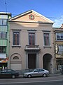
|image_caption = {{ill|District House of Borgerhout|nl|Districtshuis van Borgerhout}} |
||
|image_flag = Flag of Borgerhout (district).svg |
|||
<!-- |
|||
|image_shield = Blason ville be Borgerhout.svg |
|||
| ⚫ | |||
|image_map = {{hidden|Location of Borgerhout|{{Infobox mapframe|area_km2={{{area km2|}}}}}}} |
|||
| map_caption = District of Borgerhout within the city of Antwerp |
|||
| ⚫ | |||
--> |
|||
| |
|map_caption1 = Location of Borgerhout in Antwerp |
||
| |
|pushpin_map = Belgium#Belgium Antwerp |
||
| |
|subdivision_type = Country |
||
|subdivision_name = {{BEL}} |
|||
| pushpin_label_position = left |
|||
|subdivision_type1 = [[Communities, regions, and language areas of Belgium|Community]] |
|||
| pushpin_map_caption = Location in Belgium |
|||
| |
|subdivision_name1 = {{BE-NL}} |
||
|subdivision_type2 = [[Communities, regions, and language areas of Belgium|Region]] |
|||
| subdivision_type = Country |
|||
| |
|subdivision_name2 = {{flag|Flemish Region}} |
||
|subdivision_type3 = [[Provinces of Belgium|Province]] |
|||
| subdivision_type1 = Region |
|||
| |
|subdivision_name3 = {{BE-VAN}} |
||
|subdivision_type4 = [[Arrondissements of Belgium#Administrative|Arrondissement]] |
|||
| subdivision_type2 = Province |
|||
| |
|subdivision_name4 = [[Arrondissement of Antwerp|Antwerp]] |
||
| |
|subdivision_type5 = [[Municipalities of Belgium|Municipality]] |
||
| |
|subdivision_name5 = [[Antwerp]] |
||
| |
|coordinates = {{coord|51|13|00|N|4|26|00|E|type:city_region:BE|display=inline}} |
||
| |
|area_total_km2 = 3.93 |
||
| |
|population_as_of = 2020-01-01 |
||
| |
|population_total = 45998 |
||
|population_density_km2 = auto |
|||
| population_footnotes = <ref name="stat">{{cite web|url=https://statbel.fgov.be/sites/default/files/files/opendata/bevolking/sectoren/OPENDATA_SECTOREN_2021.xlsx |title=Bevolking per statistische sector - Sector 11002S |website=Statistics Belgium |access-date=9 May 2022 }}</ref> |
|||
| ⚫ | |||
| population_total = 45,769 |
|||
| ⚫ | |||
| population_density_km2 = auto |
|||
| ⚫ | |||
| ⚫ | |||
| |
|area_code = 03 |
||
|website = [https://www.antwerpen.be/nl/overzicht/district-borgerhout/nieuws] |
|||
| ⚫ | |||
| ⚫ | |||
}} |
}} |
||
'''Borgerhout''' ({{IPA-nl|ˈbɔrɣərˌɦʌut|-|Nl-Borgerhout.ogg}}) is the smallest [[districts of Antwerp|district]] of [[Antwerp]], [[Belgium]]. {{As of |2021}}, the district houses 45,769 inhabitants on 3,93 km².<ref name="stat"/> |
'''Borgerhout''' ({{IPA-nl|ˈbɔrɣərˌɦʌut|-|Nl-Borgerhout.ogg}}) is the smallest [[districts of Antwerp|district]] of [[Antwerp]], [[Belgium]]. {{As of |2021}}, the district houses 45,769 inhabitants on 3,93 km².<ref name="stat"/> |
||
It was an independent municipality until January 1983. The postal area code for Borgerhout is 2140. |
It was an independent municipality until January 1983. The postal area code for Borgerhout is 2140. |
||
Revision as of 14:14, 10 April 2024
Berchem | |
|---|---|
![District House of Borgerhout [nl]](/wiki/File:Borgerhout_Gemeentehuis2.JPG) | |
.svg) Flag  Coat of arms | |
Location of Borgerhout  | |
 Location of Borgerhout in Antwerp | |
 Berchem  Berchem | |
| Coordinates: 51°13′00″N 4°26′00″E / 51.21667°N 4.43333°E | |
| Country | |
| Community | |
| Region | |
| Province | |
| Arrondissement | Antwerp |
| Municipality | Antwerp |
| Area | |
| • Total | 3.93 km2 (1.52 sq mi) |
| Population (2020-01-01) | |
| • Total | 45,998 |
| • Density | 12,000/km2 (30,000/sq mi) |
| Postal codes | 2140 |
| Area codes | 03 |
| Website | [1] |
Borgerhout (Dutch pronunciation: [ˈbɔrɣərˌɦʌut] ⓘ) is the smallest district of Antwerp, Belgium. As of 2021[update], the district houses 45,769 inhabitants on 3,93 km².[1] It was an independent municipality until January 1983. The postal area code for Borgerhout is 2140.
Geography
Borgerhout is divided into two parts by a highway and the historical walls.[2] The part inside those walls is "intra muros," meaning (within the walls). It is built around a big boulevard, the Turnhoutsebaan. The Turnhoutsebaan is the biggest shopping street, offering both food and clothing, in both Belgian and foreigner's stores. "Intra muros" is the young and trendy part of Borgerhout, with a lot of so-called "hipster bars", although in the last few years "extra muros" is getting more popular and trendy, especially around the Te Boelaarpark with a lot of new businesses like bars and restaurants popping up.
Demographics
Borgerhout has an extremely diverse population, with 63% percent of inhabitants having non-Belgian ancestry. Of the nine districts of Antwerp, it has the highest population density.[3]
History
Borgerhout was first mentioned in the year 1214 in an act written by the Duke of Brabant. It was then named 'Borgerholt'.[4]
Etymology
"Borger" likely comes from the old world for citizen or city dweller. Currently, the Dutch word for this is "burger". It might also refer to the word "borgh", meaning a fortress or fortified building. Borghmeester (1254) or borgermeyster (1286) are mentioned in written sources as the word for "mayor", literally "master of the fortress" or "master of the citizens".[5] "Hout" (or previously "holt) means "wood". It is similar to some naming conventions in English, for example "Hollywood". It refers to a time when Borgerhout was still much greener, and had not yet merged with greater Antwerp. It likely also explains the tree on the coat of arms.
People from Borgerhout
Born in Borgerhout
- Bachir Boumaaza (born 1980), known by his pseudonym Athene, gaming social activist and internet personality
- Guillaume Geefs (1805–1883), sculptor
- Floris Jespers (1889–1965), painter
- Nahima Lanjri (born 1968), politician
- Sister Leontine (1923–2012), pioneer of palliative care[6]
- Milow (Jonathan Vandenbroeck) (born 1981), singer-songwriter
- André Nelis (1935–2012), sailor
- Joris Note (born 1949), writer
- Stan Ockers (1920–1956), cyclist
- Hugues C. Pernath (1931–1975), poet
- Maria Rosseels (1916–2005), journalist and actor
- Michel Seuphor (1901–1999), artist
- Paul van Morckhoven (1910–1990), dramatist and theatre critic
- Robert Van Straelen (born 1934), economist
- Thomas Vinçotte (1850–1925), sculptor
- Eddy Wauters (born 1933), football player
(Former) inhabitants of Borgerhout
- Tom De Cock (born 1983), writer and radio–DJ
- Saskia De Coster (born 1976), writer
- Bart Martens (born 1969), politician and a member of the SP.A
- Alfred Ost, (1884–1945), artist
- Anne Provoost (born 1964), writer
- Wouter Van Besien (born 1972), politician, chairman of the ecologist party Groen!
- Tom Van Laere (born 1974), musician
- Erik Van Looy (born 1962), film director
- Rik Van Steenbergen (1924–2003), racing cyclist
- Carl Verbraeken (born 1950), president of the Union of Belgian Composers
https://nl.wikipedia.org/wiki/Reuskens van Borgerhout==Gallery==
-
 Town hall until 1890
 -
 Reuskens of Borgerhout


References
- ^ Cite error: The named reference
statwas invoked but never defined (see the help page). - ^ "Kaart van Borgerhout – Kaarten van Antwerpen". 23 October 2021.
- ^ "Dashboard".
- ^ "Borgerhout".
- ^ "Waarom schrijven we burgemeester en niet burgermeester?". 15 November 2018.
- ^ "Geschiedenis". www.gza.be. Retrieved 28 August 2016.
External links
| International | |
|---|---|
| National | |
| Geographic | |