
Borgerhout: Difference between revisions
Content deleted Content added
m Date formats |
m Removing from Category:Populated places in Belgium using Cat-a-lot |
||
| Line 92: | Line 92: | ||
[[Category:Districts of Antwerp]] |
[[Category:Districts of Antwerp]] |
||
[[Category:Populated places in Antwerp (province)]] |
[[Category:Populated places in Antwerp (province)]] |
||
[[Category:Populated places in Belgium]] |
|||
{{Antwerp-geo-stub}} |
{{Antwerp-geo-stub}} |
||
Revision as of 20:41, 7 August 2020
You can help expand this article with text translated from the corresponding article in Dutch. (October 2012) Click [show] for important translation instructions.
|
Borgerhout | |
|---|---|
.svg) Flag  Coat of arms | |
 District of Borgerhout within the city of Antwerp | |
| Coordinates: 51°12′48″N 4°25′59″W / 51.21333°N 4.43306°W | |
| Country | |
| Region | |
| Province | Antwerp |
| Municipality | Antwerp |
| Area | |
| • Total | 3.93 km2 (1.52 sq mi) |
| Population (2013) | |
| • Total | 45,948 |
| Source: NIS | |
| Postal code | 2140 |
| Area code | 03 |
Borgerhout is the smallest district of Antwerp, Belgium. As of January 2013[update], the district houses 45,948 inhabitants.
Geography
Borgerhout is divided into two parts by a highway and the historical walls. The part inside those walls is intra muros (within the walls). It is built around a big boulevard, the Turnhoutsebaan. The Turnhoutsebaan is the biggest shopping street, offering both food and clothing, in both Belgian as foreigner's stores. Intra muros is the young and trendy part of Borgerhout, with a lot of so-called "hipster bars".
People from Borgerhout
Born in Borgerhout
- Bachir Boumaaza (born 1980), known by his pseudonym Athene, gaming social activist and internet personality
- Guillaume Geefs (1805–1883), sculptor
- Floris Jespers (1889–1965), painter
- Nahima Lanjri (born 1968), politician
- Sister Leontine (1923–2012), pioneer of palliative care[1]
- Milow (Jonathan Vandenbroeck) (born 1981), singer-songwriter
- André Nelis (1935–2012), sailor
- Joris Note (born 1949), writer
- Stan Ockers (1920–1956), cyclist
- Hugues C. Pernath (1931–1975), poet
- Maria Rosseels (1916–2005), journalist and actor
- Michel Seuphor (1901-1999), artist
- Robert Van Straelen (born 1934), economist
- Thomas Vinçotte (1850–1925), sculptor
- Eddy Wauters (born 1933), soccer player
- Nadia Fadil (born 1978), socio-cultural anthropologist
- Jeanne Cools (born 1922), artist
(Former) inhabitants of Borgerhout
- Tom De Cock (born 1983), writer and radio–DJ
- Saskia De Coster (born 1976), writer
- Bart Martens (born 1969), politician and a member of the SP.A
- Alfred Ost, (1884–1945), artist
- Anne Provoost (born 1964), writer
- Wouter Van Besien (born 1972), politician, chairman of the ecologist party Groen!
- Tom Van Laere (born 1974), musician
- Erik Van Looy (born 1962), film director
- Rik Van Steenbergen (1924–2003), racing cyclist
- Carl Verbraeken (born 1950), president of the Union of Belgian Composers
Gallery
-
 Borgerhout: "districtshuis"
 -
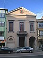 Town hall until 1890
 -
 Reuskens of Borgerhout


References
- ^ "Geschiedenis". www.gza.be. Retrieved 28 August 2016.
External links
Wikimedia Commons has media related to Borgerhout.
51°12′N 04°26′E / 51.200°N 4.433°E
| International | |
|---|---|
| National | |
| Geographic | |
This Antwerp Province location article is a stub. You can help Wikipedia by expanding it. |