
Cathedral Rock: Difference between revisions
m copyedit, refine cat, and AWB general fixes using AWB |
Epicgenius (talk | contribs) ce |
||
| (31 intermediate revisions by 26 users not shown) | |||
| Line 1: | Line 1: | ||
{{Short description|Landform in Arizona, United States}} |
|||
{{other uses}} |
|||
{{about||the rock formation in the Australian state of Tasmania|Cathedral Rock, Tasmania|other uses}} |
|||
| ⚫ | |||
{{Infobox mountain |
|||
| ⚫ | |||
| name = |
|||
| ⚫ | |||
| other_name = Cathedral Rock |
|||
| photo = Cathedral Rock - Sedona AZ-1.jpg |
|||
| photo_alt = |
|||
| photo_caption = Cathedral Rock at sunset |
|||
| elevation_ft = 4967 |
|||
| elevation_ref = {{ngvd29}}<ref name="pb">{{cite peakbagger |pid=15149 |name=Cathedral Rock, Arizona |accessdate=2016-08-22}}</ref> |
|||
| prominence_ft = 284 |
|||
| prominence_ref = <ref name="pb"/> |
|||
| range = |
|||
| listing = |
|||
| parent_peak = |
|||
| location = [[Yavapai County, Arizona|Yavapai County]], [[Arizona]], U.S. |
|||
| map = USA Arizona |
|||
| map_caption = none |
|||
| map_size = 180 |
|||
| label = |
|||
| label_position = |
|||
| coordinates = {{coord|34.8200185|N|111.7932108|W|type:mountain_region:US-AZ_scale:100000_source:GNIS|format=dms|display=inline,title}} |
|||
| range_coordinates = |
|||
| coordinates_ref = <ref name="gnis">{{cite gnis |id=27368 |name=Cathedral Rock |accessdate=2016-08-22}}</ref> |
|||
| topo = [[United States Geological Survey|USGS]] Sedona |
|||
| last_eruption = |
|||
| first_ascent = |
|||
| easiest_route = |
|||
}} |
|||
'''Cathedral Rock''' is a |
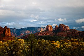
'''Cathedral Rock''' is a natural [[sandstone]] [[butte]] near [[Sedona, Arizona]], and one of the most-photographed sights in [[Arizona]], [[United States]].<ref name=Ranney>{{cite book |first=Wayne |last=Ranney |year=2010 |title=Sedona Through Time: A Guide to Sedona's Geology |publisher=Zia Publishing |edition=3rd |isbn=978-0-9701203-8-0}}</ref> The [[list of rock formations in the United States|rock formation]] is located in the [[Coconino National Forest]] in [[Yavapai County, Arizona|Yavapai County]], about {{cvt|1|mi|km}} west of [[Arizona State Route 179|Arizona Route 179]], and about {{cvt|2.5|mi|km}} south of the "Y" intersection of State Routes [[Arizona State Route 179|179]] and [[Arizona State Route 89A|89A]] in uptown Sedona. The summit elevation of Cathedral Rock is {{cvt|4,967|ft|m}}.<ref name="pb"/> |
||
The Cathedral Rock trail ([[USFS]] Trail #170) is a popular short, steep ascent from the Back O' Beyond trailhead to the saddle points or "gaps" in Cathedral Rock.<ref> |
The Cathedral Rock trail ([[USFS]] Trail #170) is a popular short, steep ascent from the Back O' Beyond trailhead to the saddle points or "gaps" in Cathedral Rock.<ref>{{cite web |url=http://www.wildsedona.com/trails/cathedral.htm |title=Cathedral Rock trail |publisher=WildSedona.com |accessdate=2016-08-22}}</ref> |
||
Geologically, Cathedral Rock is carved from the [[Permian]] Schnebly Hill formation, a [[redbed]] sandstone |
Geologically, Cathedral Rock is carved from the [[Permian]] [[Schnebly Hill formation]], a [[redbed]] sandstone formed from coastal [[sand dunes]] near the shoreline of the ancient [[Pedregosa Sea]]. [[Ripple marks]] are prominent along the lower Cathedral Rock trail, and a black [[basalt]] [[dike (geology)|dike]] may be seen in the first saddle.<ref name=Ranney/> |
||
Cathedral Rock was called "Court House Rock" on some early maps |
Cathedral Rock was called "Court House Rock" on some early maps,<ref name="gnis"/> and [[Courthouse Butte]] was called "Church House Rock",<ref>{{cite gnis |id=28076 |name=Courthouese Butte |accessdate=2016-08-22}}</ref> which has caused endless confusion ever since. |
||
<gallery mode="packed"> |
|||
| ⚫ | |||
| ⚫ | |||
| ⚫ | |||
</gallery> |
|||
==See also== |
==See also== |
||
*[[Bell Rock (Arizona)|Bell Rock]] |
* [[Bell Rock (Arizona)|Bell Rock]] |
||
*[[Courthouse Butte]] |
|||
==References== |
==References== |
||
{{reflist}} |
{{reflist}} |
||
==External links== |
==External links== |
||
| ⚫ | |||
| ⚫ | |||
{{Coord|34.8200185|N|111.7932108|W|source:GNIS|display=title}} |
|||
| ⚫ | |||
| ⚫ | |||
* {{cite summitpost |id=152506 |name=Cathedral Rock}} |
|||
[[Category: |
[[Category:Sedona, Arizona]] |
||
[[Category: |
[[Category:Buttes of Arizona]] |
||
[[Category:Rock formations of Arizona]] |
|||
[[Category:Landforms of Yavapai County, Arizona]] |
[[Category:Landforms of Yavapai County, Arizona]] |
||
[[Category:Protected areas of Yavapai County, Arizona]] |
[[Category:Protected areas of Yavapai County, Arizona]] |
||
Latest revision as of 15:55, 19 August 2023
| Cathedral Rock | |
|---|---|
| Cathedral Rock | |
 Cathedral Rock at sunset | |
| Highest point | |
| Elevation | 4,967 ft (1,514 m) NGVD 29[1] |
| Prominence | 284 ft (87 m)[1] |
| Coordinates | 34°49′12″N 111°47′36″W / 34.8200185°N 111.7932108°W[2] |
| Geography | |
 | |
| Location | Yavapai County, Arizona, U.S. |
| Topo map | USGS Sedona |
Cathedral Rock is a natural sandstone butte near Sedona, Arizona, and one of the most-photographed sights in Arizona, United States.[3] The rock formation is located in the Coconino National Forest in Yavapai County, about 1 mi (1.6 km) west of Arizona Route 179, and about 2.5 mi (4.0 km) south of the "Y" intersection of State Routes 179 and 89A in uptown Sedona. The summit elevation of Cathedral Rock is 4,967 ft (1,514 m).[1]
The Cathedral Rock trail (USFS Trail #170) is a popular short, steep ascent from the Back O' Beyond trailhead to the saddle points or "gaps" in Cathedral Rock.[4]
Geologically, Cathedral Rock is carved from the Permian Schnebly Hill formation, a redbed sandstone formed from coastal sand dunes near the shoreline of the ancient Pedregosa Sea. Ripple marks are prominent along the lower Cathedral Rock trail, and a black basalt dike may be seen in the first saddle.[3]
Cathedral Rock was called "Court House Rock" on some early maps,[2] and Courthouse Butte was called "Church House Rock",[5] which has caused endless confusion ever since.
-
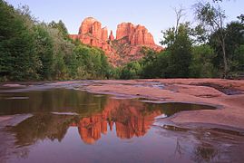 Cathedral Rock from Red Rock Crossing
 -
 These saddle points or "gaps" may be reached via the steep Cathedral Rock trail.
 -
 Cathedral Rock from Red Rock State Park


See also[edit]
References[edit]
- ^ a b c "Cathedral Rock, Arizona". Peakbagger.com. Retrieved 2016-08-22.
- ^ a b "Cathedral Rock". Geographic Names Information System. United States Geological Survey, United States Department of the Interior. Retrieved 2016-08-22.
- ^ a b Ranney, Wayne (2010). Sedona Through Time: A Guide to Sedona's Geology (3rd ed.). Zia Publishing. ISBN 978-0-9701203-8-0.
- ^ "Cathedral Rock trail". WildSedona.com. Retrieved 2016-08-22.
- ^ "Courthouese Butte". Geographic Names Information System. United States Geological Survey, United States Department of the Interior. Retrieved 2016-08-22.
External links[edit]
- "Cathedral Rock Trail". Coconino National Forest.
- "Cathedral Rock". SummitPost.org.