
Cerro de la Silla: Difference between revisions
Singegurus (talk | contribs) No edit summary |
|||
| Line 1: | Line 1: | ||
{{Infobox mountain |
{{Infobox mountain |
||
| name = Saddle |
| name = Saddle Mountain |
||
| photo = Cerro de la Silla.jpg |
| photo = Cerro de la Silla.jpg |
||
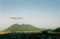
| photo_caption = Cerro de la Silla in 2004 |
| photo_caption = Cerro de la Silla in 2004 |
||
| Line 6: | Line 6: | ||
| elevation_ref = |
| elevation_ref = |
||
| prominence = |
| prominence = |
||
| translation = Cerro de la |
| translation = Cerro de la Silla |
||
| language = [[Spanish language|Spanish]] |
| language = [[Spanish language|Spanish]] |
||
| location = [[Guadalupe, Nuevo León|Guadalupe]] and [[Monterrey]], [[Nuevo León]], [[Mexico]] |
| location = [[Guadalupe, Nuevo León|Guadalupe]] and [[Monterrey]], [[Nuevo León]], [[Mexico]] |
||
| Line 19: | Line 19: | ||
It covers an area of 60.5 square kilometres (23 mi²). The mountain has four peaks: Pico Antena, Pico Norte, Pico Sur and Pico la Virgen; Pico Norte (North Peak) is the highest at 1820 m (5970 ft) while Pico la Virgen (Virgin's Peak) is the lowest at 1750 m (5740 ft). |
It covers an area of 60.5 square kilometres (23 mi²). The mountain has four peaks: Pico Antena, Pico Norte, Pico Sur and Pico la Virgen; Pico Norte (North Peak) is the highest at 1820 m (5970 ft) while Pico la Virgen (Virgin's Peak) is the lowest at 1750 m (5740 ft). |
||
Set aside as a Natural Monument by the government of Mexico in 1991, the hill is a popular recreational area and is often climbed by [[hiking|hikers]] who take a 5.3 km (3.3 mi) trail to reach the top. The ascent is considered fairly difficult, requiring approximately 3 hours to complete. A panoramic view of the city of Monterrey can be seen from the top. |
Set aside as a Natural Monument by the government of Mexico in 1991, the mountain, or ''hill'', as it is said to them also to the mountains in Mexico, is a popular recreational area and is often climbed by [[hiking|hikers]] who take a 5.3 km (3.3 mi) trail to reach the top. The ascent is considered fairly difficult, requiring approximately 3 hours to complete. A panoramic view of the city of Monterrey can be seen from the top. |
||
In the second half of the 20th century, an [[aerial tramway]] was built to give a fastest access to the iconic mountain for the population. The day of its inauguration was also the day of its closure, as a tragic accident took the lives of five people, including the engineer Jesús Fernández, its designer. Several plans have been announced to rebuild another tramway with no results.{{Citation needed|date=March 2007}} |
In the second half of the 20th century, an [[aerial tramway]] was built to give a fastest access to the iconic mountain for the population. The day of its inauguration was also the day of its closure, as a tragic accident took the lives of five people, including the engineer Jesús Fernández, its designer. Several plans have been announced to rebuild another tramway with no results.{{Citation needed|date=March 2007}} |
||
Revision as of 18:37, 20 July 2014
| Saddle Mountain | |
|---|---|
 Cerro de la Silla in 2004 | |
| Highest point | |
| Elevation | 1,820 m (5,970 ft) |
| Coordinates | 25°37′23″N 100°14′34″W / 25.62306°N 100.24278°W |
| Naming | |
| English translation | Cerro de la Silla |
| Language of name | Spanish |
| Geography | |
| Location | Guadalupe and Monterrey, Nuevo León, Mexico |
| Climbing | |
| Easiest route | Hike |
Cerro de la Silla (English: Saddle Hill), named for its distinctive saddle-shaped profile when viewed from the west, is a famous symbol of the landscape of the state of Nuevo León, Mexico. Even though the mountain itself is located in the adjacent city of Guadalupe, it is widely associated to the city of Monterrey, Mexico.
It covers an area of 60.5 square kilometres (23 mi²). The mountain has four peaks: Pico Antena, Pico Norte, Pico Sur and Pico la Virgen; Pico Norte (North Peak) is the highest at 1820 m (5970 ft) while Pico la Virgen (Virgin's Peak) is the lowest at 1750 m (5740 ft).
Set aside as a Natural Monument by the government of Mexico in 1991, the mountain, or hill, as it is said to them also to the mountains in Mexico, is a popular recreational area and is often climbed by hikers who take a 5.3 km (3.3 mi) trail to reach the top. The ascent is considered fairly difficult, requiring approximately 3 hours to complete. A panoramic view of the city of Monterrey can be seen from the top.
In the second half of the 20th century, an aerial tramway was built to give a fastest access to the iconic mountain for the population. The day of its inauguration was also the day of its closure, as a tragic accident took the lives of five people, including the engineer Jesús Fernández, its designer. Several plans have been announced to rebuild another tramway with no results.[citation needed]
Some other known mountains or elevations of the zone are: Cerro de las Mitras, the Sierra Madre Oriental with the Cerro de Chipinque —the M-shaped figure visible from various parts of the city—, the Cerro del Topo Chico, Cerro del Obispado, Cerro de la Loma Larga and La Huasteca.
Gallery
-
 Cerro de la Silla as seen from Cerro del Obispado
 -
 Atop view of Cerro de la Silla.
 -
 Monterrey view from Cerro de la Silla.


External links
- Cerro de la Silla information (Spanish)
- Mexico Desconocido (Spanish)