Guadalupe (Nuevo León)
| Guadalupe | ||
|---|---|---|
|
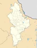
Coordinates: 25 ° 41 ′ N , 100 ° 14 ′ W Guadalupe on the map of Nuevo León
|
||
| Basic data | ||
| Country | Mexico | |
| State | Nuevo León | |
| Municipio | Guadalupe | |
| City foundation | 1716 | |
| Residents | 673,616 (2010) | |
| - in the metropolitan area | 4,106,054 | |
| City insignia | ||
| Detailed data | ||
| surface | 151 km 2 | |
| Population density | 4,461 inhabitants / km 2 | |
| height | 480 m | |
| Post Code | 67100-67199 | |
| prefix | 81 | |
| Time zone | UTC −6 | |
| City Presidency | César Garza Villarreal | |
| Website | ||
| Estadio BBVA Bancomer | ||
Guadalupe or Ciudad Guadalupe is a city in the Mexican state of Nuevo León with 673,616 inhabitants (as of 2010). Ciudad Guadalupe is 480 m above sea level. NN . Ciudad Guadalupe is a suburb in the east of Monterrey , the capital of the state, and belongs to the metropolitan area Zona Metropolitana de Monterrey . The city is u. A. Accessible from both Monterrey International Airports.
The land was inhabited long before that: in 1627 the land was parceled out into large plantations and sugar cane and corn were grown, and the city was founded on January 4, 1716 .
Web links
- Enciclopedia de los Municipios y Delegaciones de México: Guadalupe (Spanish)
- Administration page (Spanish)


