
Hoendiep
| Hoendiep | |
|---|---|
 The Hoendiep in Groningen | |
 | |
| Location | Groningen |
| Country | Netherlands |
| Coordinates | 53°13′52″N 6°23′52″E / 53.231111°N 6.397778°E |
| Specifications | |
| Length | 15 km (9.3 miles) |
| History | |
| Date of first use | 1616 |
| Geography | |
| Start point | Groningen |
| End point | Noordhornerga |
The Hoendiep (Dutch pronunciation: [ɦundip]; Gronings: Houndaip) is a canal in the Dutch province of Groningen, located between the city of Groningen and Zuidhorn. Before 1938, the current section of the Van Starkenborgh Canal from Zuidhorn to the Frisian border was also called Hoendiep. The road on the south side of the Van Starkenborgh Canal is still called Hoendiep.
The current canal is 15 km long. The settlements of Groningen, Hoogkerk, De Poffert, Enumatil, Zuidhorn and Briltil are located on the Hoendiep.
Etymology[edit]
According to Schönfeld, the name Hoendiep refers to dirty, muddy water and is related to names such as Hoerediep, Honte and Hunze.[1] The name may even be a corruption of Hunsinge, a decayed natural body of water that begins in almost the same place.
The similar name also occurs in, for example, Lower Saxony: the Hunte river. Furthermore, a gat south of the German island of Langeoog bears the name Hungat.
History[edit]
The Hoendiep originally ran from a point west of the Groninger Aapoort to De Poffert. From there, to get to Friesland, sailors sailed via the Gave (now largely disappeared) to the Lettelberterdiep. They followed this canal to Briltil and from there went via the Niekerksterdiep and the Kolonelsdiep to the Burgumer Mar. The extension of the Hoendiep between Briltil and the Oude Riet is called the Stille Diep.
From 1654 to 1657, the Hoendiep was extended from Briltil via the Stille Diep to the north to Noordhornertolhek. From there they went west, along the current route of the Van Starkenborgh Canal, until it rejoined the Kolonelsdiep near Gerkesklooster. The canal was moved in or just before 1675.[2] North of Oostwold, a connection was dug from De Poffert to the Lettelberterdiep (the current route De Poffert - Enumatil). The Gave near Oostwold lost its meaning and silted up. The new route made the connection approximately 2 km shorter. In the days of towing, this quickly meant a time saving of one hour.
In 1863, a connection was dug via the Westerhaven (part of the former city canal) with the Hoornsediep and the was constructed. Land traffic along the Westerhaven to Paterswolde, which had to cross the new connection between the Hoendiep and the Westerhaven, then used the Kroodersbrug. To improve the winding shipping route, the Eendrachts Canal was put into use in 1909. Later, the Westerhaven and the part of the canal between the harbor and the Eendrachtskanaal were filled in. The street name is still Hoendiep.
Due to the construction of the Van Starkenborgh Canal, the canal has virtually lost its function for commercial shipping. The only part that is still used as such is a section near Vierverlaten, which can be reached via the Aduarderdiep.
Gallery[edit]
-
 The Hoendiep near Stroobos
 -
 The Hoendiep in Enumatil
 -
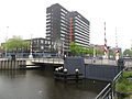 Bridge over the Hoendiep in Groningen
 -
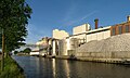 The Suikerfabriek ('Sugar Factory') on the Hoendiep
.jpg)


.jpg)
References[edit]
- ^ Schönfeld, Moritz (1955). Nederlandse waternamen. Amsterdam: Noord-Hollandsche N. V. p. 275.
- ^ Van den Broek, Jan (2015). "11.3 Inpolderingen". Groningen en het Drentse water. De geschiedenis van Groningen. Archived from the original on 24 January 2020. Retrieved 2 October 2023.