Nátaga: Difference between revisions
Content deleted Content added
m +it |
No edit summary |
||
| (19 intermediate revisions by 16 users not shown) | |||
| Line 1: | Line 1: | ||
{{Infobox |
{{Infobox settlement |
||
<!-- See Template:Infobox settlement for additional fields and descriptions --> |
|||
| ⚫ | |||
| |
|name = Nátaga |
||
|native_name = |
|||
|nickname = |
|nickname = |
||
|motto = |
|motto = |
||
| Line 8: | Line 9: | ||
|imagesize = |
|imagesize = |
||
|image_caption = |
|image_caption = |
||
|image_flag = |
|image_flag = Flag_of_Nátaga_(Huila).svg |
||
|image_seal = |
|image_seal = Escudo_de_Nataga_(Huila).svg |
||
|image_map = |
|image_map = Colombia - Huila - Nátaga.svg |
||
|mapsize = 250px |
|mapsize = 250px |
||
|map_caption = Location of the municipality and town of Nataga in the Huila Department of Colombia. |
|map_caption = Location of the municipality and town of Nataga in the Huila Department of Colombia. |
||
|pushpin_map = |
|pushpin_map = |
||
|pushpin_mapsize =300 |
|pushpin_mapsize = 300 |
||
|pushpin_map_caption |
|pushpin_map_caption = Location in Colombia |
||
|subdivision_type = Country |
|subdivision_type = Country |
||
|subdivision_name = {{flag|Colombia}} |
|subdivision_name = {{flag|Colombia}} |
||
|subdivision_type1 |
|subdivision_type1 = [[Departments of Colombia|Department]] |
||
|subdivision_name1 |
|subdivision_name1 = [[Huila Department]] |
||
|subdivision_type2 = |
|subdivision_type2 = |
||
|subdivision_name2 = |
|subdivision_name2 = |
||
| Line 47: | Line 48: | ||
|population_density_metro_sq_mi = |
|population_density_metro_sq_mi = |
||
|population_urban = |
|population_urban = |
||
| ⚫ | |||
|latd=|latm=|lats= |latNS=N |
|||
|longd=|longm=|longs= |longEW=W |
|||
|timezone = Colombia Standard Time |
|timezone = Colombia Standard Time |
||
|utc_offset = -5 |
|utc_offset = -5 |
||
| Line 55: | Line 55: | ||
|elevation_m = |
|elevation_m = |
||
|elevation_ft = |
|elevation_ft = |
||
|website = |
|website = http://www.nataga-huila.gov.co/ |
||
|footnotes = |
|footnotes = |
||
}} |
}} |
||
| ⚫ | |||
| ⚫ | |||
{{Municipalities huila department}} |
{{Municipalities huila department}} |
||
{{coord|2|33|N|75|50|W|display=title|region:CO_type:city_source:GNS-enwiki}} |
{{coord|2|33|N|75|50|W|display=title|region:CO_type:city_source:GNS-enwiki}} |
||
{{DEFAULTSORT:Nataga}} |
|||
[[Category:Municipalities of Huila]] |
[[Category:Municipalities of Huila Department]] |
||
| ⚫ | |||
[[Category:Cities, towns and villages in the Huila Department]] |
|||
| ⚫ | |||
[[it:Nátaga]] |
|||
[[nl:Nátaga]] |
|||
[[pt:Nataga]] |
|||
Latest revision as of 21:18, 28 July 2021
Nátaga | |
|---|---|
Municipality and town | |
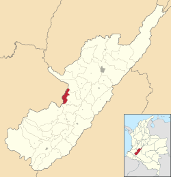
 Location of the municipality and town of Nataga in the Huila Department of Colombia. | |
| Country | |
| Department | Huila Department |
| Time zone | UTC-5 (Colombia Standard Time) |
| Website | http://www.nataga-huila.gov.co/ |
Nátaga (Spanish pronunciation: [ˈnataɣa]) is a town and municipality in the Huila Department, Colombia.


