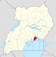
Nkokonjeru
This article is actively undergoing a major edit for a short while. To help avoid edit conflicts, please do not edit this page while this message is displayed. This page was last edited at 11:10, 20 July 2015 (UTC) (8 years ago) – this estimate is cached, . Please remove this template if this page hasn't been edited for a significant time. If you are the editor who added this template, please be sure to remove it or replace it with {{Under construction}} between editing sessions. |
Nkokonjeru | |
|---|---|
| Country | |
| Region | Central Uganda |
| District | Buikwe District |
| Elevation | 3,900 ft (1,200 m) |
| Population (2011 Estimate) | |
| • Total | 14,000 |
Nkokonjeru is a town in Buikwe District, Central Uganda. The town is a municipality under Buikwe District Administration.[1] The other municipalities in the district include: (a) Buikwe Municipality (b) Lugazi Municipality (c) Njeru Municipality (d) Ngogwe Municipality and (e) Nyenga Municipality. The town's name translates into White Chicken in English.[2]
Location
Nkokonjeru is located in Buikwe District, approximately 23 kilometres (14 mi), by road, southwest of Buikwe, the location of the district headquarters.[3] The town is located approximately 46 kilometres (29 mi), by road, southwest of Njeru, the largest urban centre in the district.[4] This location is approximately 50 kilometres (31 mi), by road, southeast of Kampala, the capital of Uganda and the largest city in the country.[5] The coordinates of Nkokonjeru are:0°14'22.0"N, 32°55'23.0"E (Latitude:0.239444; Longitude:32.923056).[6]
Overview
Nkokonjeru was the location of a traditional shine where the Baganda used to sacrifice white chicken prior to 1890.[2] In 1891, the Mill Hill Fathers established a Catholic Parish in the area. When lightning felled the sacrifice tree, the missionaries used the wood to burn bricks and build the Parish Church. Subsequently, they built schools, a hospital and a teacher's college. The Catholic Parish of Nkonkonjeru had over 45,000 registered parishioners, as of August 2009.[7]
Population
The 2002 national census enumerated the population of Nkokonjeru at 11,095. In 2010, the Uganda Bureau of Statistics (UBOS), estimated the population of the town at 13,700. In 2011, UBOS estimated the mid-year population of Nkokonjeru at 14,000.[8]
Points of interest
The following points of interest lie within or near Nkokonjeru:
- The offices of Nkokonjeru Town Council
- St. Francis Hospital, Nkokonjeru - A 200 bed community hospital administered by the Roman Catholic Diocese of Lugazi[9]
- Nkokonjeru Church of Uganda Primary School
- St. Paul's Primary School, Nkokonjeru
- St. Peter's Secondary School, Nkokonjeru
- Nkokonjeru Teacher Training College
- Nkokonjeru Technical College
- Nkokonjeru Catholic Church
- Stella Maris Boarding Primary School, Nsuube
- Stella Maris College, Nsuube
- St. Alphonsus Demonstration School
- St. Anthony Convent Secondary School
- Providence Home
- Rural Agency for Sustainable Development (RASD)
- Nkokonjeru Savings and Credit Co-operative (SACCO)
- Mother Kevin Vocation Institute
- St. Claire Primary School
- Little Angels Primary School[10]
External links
See also
References
- ^ Kyotalengerire, Agnes (2 September 2013). "Nalugo's Gospel: Proper Nutrition Starts At The Breast". New Vision. Kampala. Retrieved 20 July 2015.
- ^ a b Okwera, Oyet (3 October 2008). "A Sacred Tree Built Nkokonjeru Chapel". New Vision. Kampala. Retrieved 20 July 2015.
- ^ GFC, . (20 July 2015). "Map Showing Nkokonjeru And Buikwe With Route Marker". Globefeed.com (GFC). Retrieved 20 July 2015.
{{cite web}}:|first=has numeric name (help) - ^ GFC, . (20 July 2015). "Road Distance Between Njeru And Nkokonjeru With Map". Globefeed.com (GFC). Retrieved 20 July 2015.
{{cite web}}:|first=has numeric name (help) - ^ GFC, . (20 July 2015). "Map Showing Nkokonjeru And Kampala With Route Marker". Globefeed.com (GFC). Retrieved 20 July 2015.
{{cite web}}:|first=has numeric name (help) - ^ Google (20 July 2015). "Location of Nkokonjeru At Google Maps accessdate=20 July 2015" (Map). Google Maps. Google. Retrieved 20 July 2015.
{{cite map}}: Missing pipe in:|title=(help) - ^ Lukwago, Juliet (11 July 2008). "Nkokonjeru Catholic Parish Through 111 Years". new Vision. Kampala. Retrieved 20 July 2015.
- ^ UBOS, . (2012). "Population Estimates for Nkokonjeru In 2002, 2010 And 2011" (PDF). Uganda Bureau of Statistics (UBOS). Retrieved 20 July 2015.
{{cite web}}:|first=has numeric name (help) - ^ "Nkokonjeru Hospital Gets X-ray Machine". New Vision. Kampala. 26 January 2007. Retrieved 20 July 2015.
- ^ About Nkokonjeru Catholic Parish

