
Plătărești
Plătărești | |
|---|---|
 Plătărești Monastery church | |
 Location in Călărași County | |
 Plătărești Location in Romania | |
| Coordinates: 44°21′N 26°22′E / 44.350°N 26.367°E | |
| Country | Romania |
| County | Călărași |
| Government | |
| • Mayor (2020–2024) | Florin Dumitrescu (PNL) |
| Area | 50.12 km2 (19.35 sq mi) |
| Elevation | 50 m (160 ft) |
| Population (2021-12-01)[1] | 3,955 |
| • Density | 79/km2 (200/sq mi) |
| Time zone | EET/EEST (UTC+2/+3) |
| Postal code | 917200 |
| Area code | +40 x42 |
| Vehicle reg. | CL |
| Website | www |
Plătărești is a commune in Călărași County, Muntenia, Romania. It is composed of four villages: Cucuieți, Dorobanțu, Plătărești, and Podu Pitarului.
The commune is located in the southwestern reaches of the Bărăgan Plain, in the western part of the county.
At the 2011 census, Plătărești had a population of 4,178. Of those, 88.61% were ethnic Romanians and 4.14% Roma.
Plătărești Monastery was built in 1632–1646 by Voivode Matei Basarab.
Natives[edit]
References[edit]
-
 Entrance to Plătărești Monastery
 -
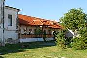 Monastic home at Plătărești Monastery


This Călărași County location article is a stub. You can help Wikipedia by expanding it. |