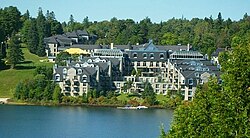
Sainte-Adèle
Sainte-Adèle | |
|---|---|
 Downtown Sainte-Adèle | |
 Location within Les Pays-d'en-Haut RCM. | |
| Country | |
| Province | |
| Region | Laurentides |
| RCM | Les Pays-d'en-Haut |
| Constituted | August 27, 1997 |
| Government | |
| • Mayor | Réjean Charbonneau |
| • Federal riding | Laurentides—Labelle |
| • Prov. riding | Bertrand |
| Area | |
| • Total | 125.30 km2 (48.38 sq mi) |
| • Land | 120.90 km2 (46.68 sq mi) |
| Population (2011)[2] | |
| • Total | 12,137 |
| • Density | 100.4/km2 (260/sq mi) |
| • Pop (2006–11) | |
| Time zone | UTC−5 (EST) |
| • Summer (DST) | UTC−4 (EDT) |
| Postal code(s) | |
| Area code(s) | 450 and 579 |
| Website | www |
Sainte-Adèle is a municipality in Quebec, Canada, and is part of the Les Pays-d'en-Haut Regional County Municipality. It lies on the Route 117 (Trans-Canada Highway) about 70 kilometres (43 mi) north-west of Montreal. Its tourism-based economy centres on its skiing and hotel industry. Sainte-Adèle had a population of 12,137 as of 2011.[4]
History

In 1842 Augustin-Norbert Morin purchased land in the area that would become Sainte-Adèle for 8¢ per arpent, which colonists arriving soon after then purchased from him for $8 CAD per arpent. The town of Sainte-Adèle was founded in 1855. A rail line was constructed and the first Canadian Pacific Railway train arrived in the town in 1891. The railway was used primarily to transport wood, cattle, dairy products, and mail.
The first "ski resort", Chalet Cochand, was built in 1914, followed by The Alpine Inn in 1924. More hotels and expansions of local ski slopes followed. Sainte-Adèle's local newspaper, Le Journal des Pays d'en Haut, was established in 1967. Supporting the thriving hotel and resort business of the time, the École Hôtelières des Laurentides (Hotel School of the Laurentians) opened in 1983.
In 1991 the railway was decommissioned and converted to a park for cyclists and skiers. The town has since abandoned the tourism industry in favour of residential development. In 2006 and 2007 respectively, both ski hills in the village centre were closed, the North side of the Chantecler ski hill remains open as does Mont Gabriel . Also during this era, more land was being used for condominium complexes, attracting more permanent residents to the area.
In 2009, municipal taxes were doubled to what they were in the early 1990s to reflect the high demand for real estate that has been experienced in the municipality in recent years, and the beautiful landscape is now dotted with condos and strip malls, including the 500th Tim Hortons donut shop in Canada.
Municipal history
The municipal status of Sainte-Adèle and the surrounding areas was the subject of personal, local, provincial, and national politics several times in its history. A coarse timeline of these divisions and fusions follows:
- 1918: Mont-Rolland is separated from Sainte-Adèle and created as a factory town.
- 1922: Val-Morin becomes an independent municipality.
- 1922: Sainte-Adèle was divided into the municipalities of Sainte-Adèle-en-Haut and Sainte-Adèle-en-Bas along class lines.
- 1948: Owners of the Chantecler Hotel petition the Ministère des Affaires municipales for the right to create the Village of Chantecler.
- 1951: Sainte-Marguerite-Station demands the right to secede from Sainte-Adèle.
- 1954: The Mont-Gabriel becomes a municipality with only nine citizens.
- 1964: Sainte-Adèle-en-Haut and Sainte-Adèle-en-Bas are reunited.
- 1967: Village de Séraphin is created.
- 1968: Part of Mont-Rolland (Sommet Bleu) is annexed by Sainte-Adèle.
- 1981: Mont-Gabriel becomes part of Mont-Rolland.
- 1997: Sainte-Adèle and Mont-Rolland are rejoined.
Sainte-Adèle was the setting of the long-running Quebec television series Les Belles Histoires des pays d'en haut, an adaptation of Claude-Henri Grignon's novel Un Homme et son péché.
Demographics
Population trend:[5]
- Population in 2011: 12137 (2006 to 2011 population change: 14.1%)
- Population in 2006: 10634
- 2001 to 2006 population change: 15.4%
- Population in 2001: 9215
- Population in 1996: 8719
- Sainte-Adèle (Ville): 5837
- Mont-Rolland (Village): 2882
- Population in 1991:
- Sainte-Adèle (Ville): 4916
- Mont-Rolland (Village): 2449
Private dwellings occupied by usual residents: 5781 (total dwellings: 7193)
Mother tongue:
- English as first language: 5%
- French as first language: 90%
- English and French as first language: 1%
- Other as first language: 4%
See also
References
- ^ a b "Répertoire des municipalités: Geographic code 77022". www.mamh.gouv.qc.ca (in French). Ministère des Affaires municipales et de l'Habitation.
- ^ a b "Sainte-Adèle (Code 2477022) Census Profile". 2011 census. Government of Canada - Statistics Canada.
- ^ "Banque de noms de lieux du Québec: Reference number 336120". toponymie.gouv.qc.ca (in French). Commission de toponymie du Québec.
- ^ "Sainte-Adèle Quebec (Ville)". 2006 Community Profiles. Statistics Canada. Retrieved 2006-06-16.
- ^ Statistics Canada: 1996, 2001, 2006, 2011 census
- "Histoire de Sainte-Adèle" (in French). Ville de Sainte-Adèle. Retrieved 2006-06-16.
External links
![]() Media related to Sainte-Adèle, Quebec at Wikimedia Commons
Media related to Sainte-Adèle, Quebec at Wikimedia Commons
- Template:Fr icon Le Journal des Pays d'en Haut — Sainte-Adèle's newspaper
- Template:Fr icon Motel Chantolac - Au coeur de Ste-Adèle, à 2 pas du Lac Rond & Restos...
