
Vinkeveen: Difference between revisions
No edit summary Tags: Mobile edit Mobile web edit |
No edit summary |
||
| (20 intermediate revisions by 8 users not shown) | |||
| Line 1: | Line 1: | ||
{{Infobox settlement |
{{Infobox settlement |
||
|name = Vinkeveen |
| name = Vinkeveen |
||
| |
| settlement_type = Village |
||
| |
| official_name = <!-- if different from name --> |
||
| native_name = <!-- if different from name --> |
|||
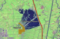
|map_caption = The village of Vinkeveen (darkgreen) and the neighbourhood of Vinkeveen (lightgreen) in the municipality of De Ronde Venen |
|||
| native_name_lang = nl |
|||
| ⚫ | |||
| |
| image_skyline = File:Vinkeveen 2020 07 18 18 49.jpg |
||
| ⚫ | |||
| ⚫ | |||
| image_caption = Canal access to houses |
|||
| ⚫ | |||
| image_flag = |
|||
| ⚫ | |||
| image_shield = File:Vinkeveen wapen.svg |
|||
| ⚫ | |||
| nickname = |
|||
|subdivision_type2 = Municipality |
|||
| motto = |
|||
| ⚫ | |||
| |
| image_map = |
||
| map_caption = |
|||
| ⚫ | |||
| |
| image_map1 = |
||
| |
| map_caption1 = |
||
| pushpin_map = Netherlands Utrecht#Netherlands |
|||
| ⚫ | |||
| pushpin_label_position = |
|||
|area_code_type = Dialling code |
|||
| pushpin_map_caption = Location in the Netherlands |
|||
| ⚫ | |||
| ⚫ | |||
| ⚫ | |||
| ⚫ | |||
| ⚫ | |||
| subdivision_type2 = [[List of municipalities of the Netherlands|Municipality]] |
|||
| ⚫ | |||
| leader_title = |
|||
| leader_name = |
|||
| leader_party = |
|||
| elevation_footnotes = <ref name="AHN">{{cite web |url = http://www.ahn.nl/postcodetool |title = Postcodetool for 1427AA |language = nl |work = Actueel Hoogtebestand Nederland |publisher = Het Waterschapshuis |access-date = 28 March 2022 }}</ref> |
|||
| elevation_m = -1.8 |
|||
| elevation_min_m = |
|||
| elevation_max_m = |
|||
| area_footnotes = <ref name="stat"/> |
|||
| area_total_km2 = 25.58 |
|||
| established_title = |
|||
| established_date = |
|||
| population_footnotes = <ref name="stat">{{cite web |url=https://www.cbs.nl/-/media/_excel/2021/48/kwb-2021.xls |title=Kerncijfers wijken en buurten 2021 |website=Central Bureau of Statistics |access-date=28 March 2022|quote=two entries}}</ref> |
|||
| population_total = 9,545 |
|||
| ⚫ | |||
| population_demonym = |
|||
| population_note = |
|||
| population_density_km2 = auto |
|||
| timezone = [[Central European Time|CET]] |
|||
| utc_offset = +1 |
|||
| timezone_DST = [[Central European Summer Time|CEST]] |
|||
| utc_offset_DST = +2 |
|||
| postal_code_type = [[List of postal codes in the Netherlands|Postal code]] |
|||
| ⚫ | |||
| area_code_type = [[Telephone numbers in the Netherlands|Dialing code]] |
|||
| area_code = 0297 |
|||
| website = |
|||
| footnotes = |
|||
| ⚫ | |||
}} |
}} |
||
'''Vinkeveen''' is a |
'''Vinkeveen''' is a village in the [[Netherlands|Dutch]] province of [[Utrecht (province)|Utrecht]]. It is a part of the municipality of [[De Ronde Venen]], and lies about 18 km south of [[Amsterdam]]. |
||
| ⚫ | |||
The neighbourhood of Vinkeveen, which covers the town of Vinkeveen and the neighbouring hamlet of [[Achterbos]], has about 8400 inhabitants.<ref name="CBS2">Statistics Netherlands (CBS), ''Gemeente Op Maat 2004: De Ronde Venen'' [http://www.cbs.nl/nl-NL/menu/themas/nederland-regionaal/nederland-regionaal/publicaties/gemeente-op-maat/2004/alfabet/r/2004-de-ronde-venen.htm].</ref> |
|||
| ⚫ | Vinkeveen is best known for the '''Vinkeveense Plassen''' (Lakes of Vinkeveen), an area of lakes and sand islands east of the village. It is an important recreational area, with facilities for swimming, diving and yachting.<ref name="plaats"/> A permit is required for recreational diving in the lake. There is a [[marina]] on the north shore of the lakes. |
||
| ⚫ | |||
== History == |
|||
[[Image:Vinkeveense Plassen.jpg|right|thumb|Satellite image of Vinkeveen and the Vinkeveense Plassen]] |
|||
It was first mentioned between 1395 and 1396 as Vinkenveen, and means "moorland with low quality [[peat]]".<ref>{{cite web|url=https://etymologiebank.nl/trefwoord/vinkeveen |title=Vinkeveen - (geografische naam) |website=Etymologiebank |access-date=28 March 2022|language=nl}}</ref> The village started as a peat excavation settlement.<ref name="monument">{{cite web|url=https://www.dbnl.org/tekst/sten009monu01_01/sten009monu01_01_0077.php |title=Amstelhoek |author=Ronald Stenvert & Chris Kolman |year=1996 |publisher=Waanders |location=Zwolle |isbn=90 400 9757 7 |language=nl |access-date=28 March 2022}}</ref> In 1840, it was home to 903 people.<ref name="plaats">{{cite web|url=https://www.plaatsengids.nl/vinkeveen |title=Vinkeveen |website=Plaatsengids |access-date=28 March 2022 |language=nl}}</ref> The Catholic Holy Heart Church was built between 1880 and 1883.<ref name="monument"/> |
|||
| ⚫ | Vinkeveen is |
||
== Gallery == |
|||
<gallery> |
|||
Image:Vinkeveense Plassen.jpg|Satellite image of Vinkeveen and the Vinkeveense Plassen, retrieved in October, 2005 -- note that as of August 2021, the boundaries of Vinkeveen have expanded, considerably. |
|||
File:Demmerik een buurtschap bij Vinkeveen.jpg|The landscape with wide waters and narrow roads in the hamlet of Demmerik in Vinkeveen Gem De Ronde Venen. |
|||
File:Overzicht van de zuidwestzijde van de kerk vanaf het kerkhof - Vinkeveen - 20420530 - RCE.jpg|A church in Vinkeveen |
|||
File:Vinkeveen, Kerklaan 2, rk pastorie - img0011.jpg|An historical monument in Vinkeveen |
|||
</gallery> |
|||
==References== |
==References== |
||
| Line 40: | Line 82: | ||
[[Category:Former municipalities of Utrecht (province)]] |
[[Category:Former municipalities of Utrecht (province)]] |
||
[[Category:De Ronde Venen]] |
[[Category:De Ronde Venen]] |
||
{{Utrecht-geo-stub}} |
|||
Latest revision as of 20:50, 18 April 2024
Vinkeveen | |
|---|---|
Village | |
 Canal access to houses | |
 Coat of arms | |
 Vinkeveen Location in the Netherlands  Vinkeveen Vinkeveen (Netherlands) | |
| Coordinates: 52°12′46″N 4°55′38″E / 52.21278°N 4.92722°E | |
| Country | Netherlands |
| Province | Utrecht |
| Municipality | De Ronde Venen |
| Area | |
| • Total | 25.58 km2 (9.88 sq mi) |
| Elevation | −1.8 m (−5.9 ft) |
| Population (2023)[1] | |
| • Total | 9,545 |
| • Density | 370/km2 (970/sq mi) |
| Time zone | UTC+1 (CET) |
| • Summer (DST) | UTC+2 (CEST) |
| Postal code | 3645[1] |
| Dialing code | 0297 |
Vinkeveen is a village in the Dutch province of Utrecht. It is a part of the municipality of De Ronde Venen, and lies about 18 km south of Amsterdam.
Vinkeveen used to be a separate municipality. It merged with Waverveen in 1841, to form the municipality Vinkeveen en Waverveen. In 1989 there was a reorganisation of local governments, and Vinkeveen became a part of De Ronde Venen.[3]
Vinkeveen is best known for the Vinkeveense Plassen (Lakes of Vinkeveen), an area of lakes and sand islands east of the village. It is an important recreational area, with facilities for swimming, diving and yachting.[3] A permit is required for recreational diving in the lake. There is a marina on the north shore of the lakes.
History[edit]
It was first mentioned between 1395 and 1396 as Vinkenveen, and means "moorland with low quality peat".[4] The village started as a peat excavation settlement.[5] In 1840, it was home to 903 people.[3] The Catholic Holy Heart Church was built between 1880 and 1883.[5]
Gallery[edit]
-
 Satellite image of Vinkeveen and the Vinkeveense Plassen, retrieved in October, 2005 -- note that as of August 2021, the boundaries of Vinkeveen have expanded, considerably.
 -
 The landscape with wide waters and narrow roads in the hamlet of Demmerik in Vinkeveen Gem De Ronde Venen.
 -
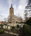 A church in Vinkeveen
 -
 An historical monument in Vinkeveen


References[edit]
- ^ a b c "Kerncijfers wijken en buurten 2021". Central Bureau of Statistics. Retrieved 28 March 2022.
two entries
- ^ "Postcodetool for 1427AA". Actueel Hoogtebestand Nederland (in Dutch). Het Waterschapshuis. Retrieved 28 March 2022.
- ^ a b c "Vinkeveen". Plaatsengids (in Dutch). Retrieved 28 March 2022.
- ^ "Vinkeveen - (geografische naam)". Etymologiebank (in Dutch). Retrieved 28 March 2022.
- ^ a b Ronald Stenvert & Chris Kolman (1996). "Amstelhoek" (in Dutch). Zwolle: Waanders. ISBN 90 400 9757 7. Retrieved 28 March 2022.
| International | |
|---|---|
| National | |
| Geographic | |