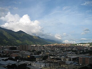
Ávila massif
Ávila is the common name for the mountain range north of the Venezuelan capital Caracas and a 2250 meter high mountain that is located in it.
| Ávila massif | |
|---|---|
|
View across Caracas to the Ávila massif |
|
| Highest peak | Pico Naiguatá ( 2765 m ) |
| location | Venezuelan states of Vargas and Miranda , as well as Distrito Federal |
| part of | Venezuelan coastal cordillera |
| Coordinates | 10 ° 32 ′ N , 66 ° 52 ′ W |
Surname
According to the story, the Ávila massif got its name from a Spanish colonial ruler named Gabriel de Ávila, who took possession of the lands between the valley of Caracas and the main ridge line of the massif for himself.
The indigenous name used by the indigenous people - the Caracas and Taromaimas - for the mountain range is Guaraira Repano and means "Great Mountains". However, there are also other interpretations for the indigenous name.
geography
location
The Ávila massif represents part of the outer chain of the so-called central branch (span: rama central ) of the Venezuelan coastal cordillera . It extends for about 100 km between the Quebrada Tacagua in the west to Cape Codera in the east. In the north the massif is bounded by the Caribbean Sea , in the south by the high valley of Caracas .
Surveys
The Ávila massif is home to the highest peaks of the Venezuelan coastal cordillera . These include the Pico Naiguatá (2765 m), the Pico Oriental de la Silla de Caracas (2640 m), the Topo Galindo (2592 m) and the Pico Occidental de la Silla de Caracas with 2480 m. The Silla de Caracas (German: Caracas chair , after its saddle shape) was first climbed by Alexander von Humboldt and Aimé Bonpland . The young Andrés Bello allegedly also took part in the expedition .
origin
The Ávila massif , like the entire Venezuelan coastal cordillera , owes itself primarily to the elevation of the Caribbean over the South American plate and still grows about one centimeter per year.
use
During the 18th, 19th and early 20th centuries, the slopes, especially on the south side of the massif, were used intensively for growing coffee . Today most of Ávila belongs to the Guaraira Repano National Park (formerly El Ávila ).
literature
- Stefan Amend: The National Park “El Avila” - Change of meaning and management problems of a region near the capital in Venezuela (Mainz Geographical Studies. Heft 33), o. O. 1990.
- Winfried Meier: Flora y vegetación del Parque Nacional El Ávila (Venezuela, Cordillera de la Costa) , con especial énfasis en los bosques nublados con 88 figuras y 38 tablas en el texto y una galería de photos en la parte III, Freiburg 2004.
- Eduardo Rosswaag: Por los Caminos del Ávila , o. O. o. J.
Web links
- www.el-avila.com Website of the National Park (Spanish)
