Île Foch
| Île Foch | ||
|---|---|---|
| Île Foch in May 1999 | ||
| Waters | Indian Ocean | |
| Archipelago | Kerguelen | |
| Geographical location | 49 ° 0 ′ S , 69 ° 17 ′ E | |
|
|
||
| length | 28 km | |
| surface | 206.2 km² | |
| Highest elevation | Pyramid Mexicaine 687 m |
|
| Residents | uninhabited | |
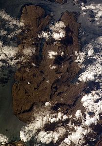
| NASA image of the Ile Foch | ||
The Île Foch [ fɔʃ ] is 206.2 km² (slightly larger than, for example, the German Baltic Sea island Fehmarn ) the second largest island of the Kerguelen Archipelago in the southern Indian Ocean . The island is named after the French officer Ferdinand Foch (1851–1929).
geography
The 28 kilometers long island is bordered by the land masses of the Société de Géographie and Joffre peninsulas and the islands of Saint-Lanne Gramont and Howe . In the mountain ranges of the interior of the island and the northeast, the mountain peaks sometimes reach a height of 400 to 600 meters, the highest point is marked by the Mexicaine pyramid at 687 meters.
fauna and Flora
Almost untouched by external influences, the island forms an ecosystem that has the original vegetation of the Kerguelen before the colonization attempts. There are none of the vertebrate species introduced by humans, such as rabbits, cats, rats and mice, which could seriously endanger either the natural vegetation or the bird population. In order to maintain this condition as far as possible, access to the Île Foch is severely restricted and subject to strict regulations.
Individual evidence
- ↑ Îles Kerguelen. Topographic map 1: 200,000. In: Géoportail. Institut national de l'information geographique et forestière (IGN), accessed on May 15, 2017 (French).


